Volcanoes - Ministry of Civil Defence and Emergency Management
Volcanoes - Ministry of Civil Defence and Emergency Management
Volcanoes - Ministry of Civil Defence and Emergency Management

You also want an ePaper? Increase the reach of your titles
YUMPU automatically turns print PDFs into web optimized ePapers that Google loves.
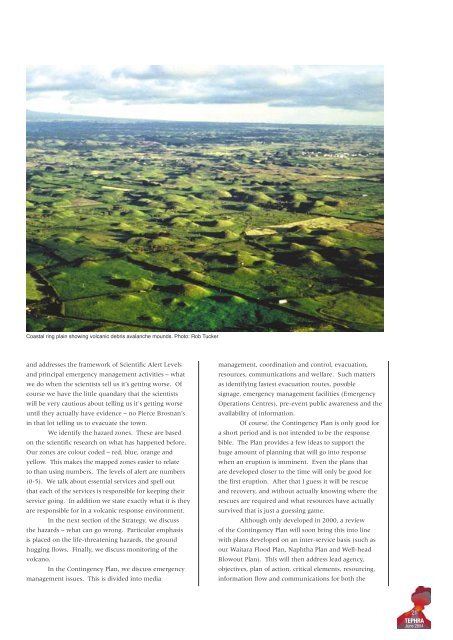
Coastal ring plain showing volcanic debris avalanche mounds. Photo: Rob Tucker<br />
<strong>and</strong> addresses the framework <strong>of</strong> Scientific Alert Levels<br />
<strong>and</strong> principal emergency management activities – what<br />
we do when the scientists tell us it’s getting worse. Of<br />
course we have the little qu<strong>and</strong>ary that the scientists<br />
will be very cautious about telling us it's getting worse<br />
until they actually have evidence – no Pierce Brosnan’s<br />
in that lot telling us to evacuate the town.<br />
We identify the hazard zones. These are based<br />
on the scientific research on what has happened before.<br />
Our zones are colour coded – red, blue, orange <strong>and</strong><br />
yellow. This makes the mapped zones easier to relate<br />
to than using numbers. The levels <strong>of</strong> alert are numbers<br />
(0-5). We talk about essential services <strong>and</strong> spell out<br />
that each <strong>of</strong> the services is responsible for keeping their<br />
service going. In addition we state exactly what it is they<br />
are responsible for in a volcanic response environment.<br />
In the next section <strong>of</strong> the Strategy, we discuss<br />
the hazards – what can go wrong. Particular emphasis<br />
is placed on the life-threatening hazards, the ground<br />
hugging flows. Finally, we discuss monitoring <strong>of</strong> the<br />
volcano.<br />
In the Contingency Plan, we discuss emergency<br />
management issues. This is divided into media<br />
management, coordination <strong>and</strong> control, evacuation,<br />
resources, communications <strong>and</strong> welfare. Such matters<br />
as identifying fastest evacuation routes, possible<br />
signage, emergency management facilities (<strong>Emergency</strong><br />
Operations Centres), pre-event public awareness <strong>and</strong> the<br />
availability <strong>of</strong> information.<br />
Of course, the Contingency Plan is only good for<br />
a short period <strong>and</strong> is not intended to be the response<br />
bible. The Plan provides a few ideas to support the<br />
huge amount <strong>of</strong> planning that will go into response<br />
when an eruption is imminent. Even the plans that<br />
are developed closer to the time will only be good for<br />
the first eruption. After that I guess it will be rescue<br />
<strong>and</strong> recovery, <strong>and</strong> without actually knowing where the<br />
rescues are required <strong>and</strong> what resources have actually<br />
survived that is just a guessing game.<br />
Although only developed in 2000, a review<br />
<strong>of</strong> the Contingency Plan will soon bring this into line<br />
with plans developed on an inter-service basis (such as<br />
our Waitara Flood Plan, Naphtha Plan <strong>and</strong> Well-head<br />
Blowout Plan). This will then address lead agency,<br />
objectives, plan <strong>of</strong> action, critical elements, resourcing,<br />
information flow <strong>and</strong> communications for both the<br />
21<br />
TEPHRA<br />
June 2004