Sunshine Coast Aquatic Plan 2011-2026 - Sunshine Coast Council
Sunshine Coast Aquatic Plan 2011-2026 - Sunshine Coast Council
Sunshine Coast Aquatic Plan 2011-2026 - Sunshine Coast Council

Create successful ePaper yourself
Turn your PDF publications into a flip-book with our unique Google optimized e-Paper software.
Kureelpa<br />
- Kiamba<br />
Marcoola - Twin Waters<br />
Pacific Paradise - Mudjimba<br />
Somerset<br />
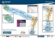
Regional<br />
<strong>Council</strong><br />
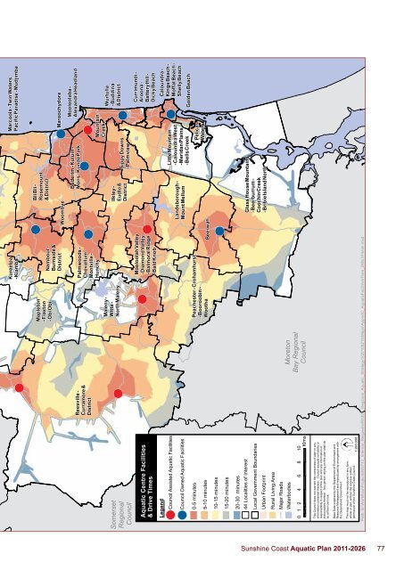
<strong>Aquatic</strong> Centre Facilities<br />
& Drive Times<br />
Legend<br />
<strong>Council</strong> Assisted <strong>Aquatic</strong> Facilities<br />
<strong>Council</strong> Owned <strong>Aquatic</strong> Facilities<br />
0-5 minutes<br />
5-10 minutes<br />
10-15 minutes<br />
15-20 minutes<br />
Somerset<br />
Regional<br />
<strong>Council</strong><br />
Reesville -<br />
Curramore &<br />
District<br />
Mapleton<br />
- Flaxton<br />
- Obi Obi<br />
Maleny -<br />
Witta -<br />
North Maleny<br />
Nambour -<br />
Burnside &<br />
District<br />
Palmwoods -<br />
Chevallum -<br />
Montville -<br />
Hunchy<br />
Peachester - Crohamhurst<br />
- Booroobin -<br />
Wootha<br />
Mooloolah Valley<br />
- Diamond Valley<br />
- Balmoral Ridge<br />
- Bald Knob<br />
Beerwah<br />
Woombye<br />
Bli Bli -<br />
Rosemount<br />
& District<br />
Ilkley -<br />
Eudlo &<br />
District<br />
Landsborough -<br />
Mount Mellum<br />
Buderim - Kuluin -<br />
Mons - Kunda Park<br />
Sippy Downs<br />
- Palmview<br />
Little Mountain<br />
- Caloundra West<br />
- Meridan Plains<br />
- Bells Creek<br />
Pelican<br />
Waters<br />
Maroochydore<br />
Mountain<br />
Creek<br />
Mooloolaba -<br />
Alexandra Headland<br />
Wurtulla<br />
- Buddina<br />
& District<br />
Currimundi -<br />
Aroona -<br />
Battery Hill -<br />
Dicky Beach<br />
Caloundra -<br />
Kings Beach -<br />
Moffat Beach -<br />
Shelly Beach<br />
Golden Beach<br />
20-30 minutes<br />
44 Localities of Interest<br />
Local Government Boundaries<br />
Urban Footprint<br />
Rural Living Area<br />
Major Roads<br />
Waterbodies<br />
0 1 2 4 6 8 10<br />
Klms<br />
Moreton<br />
Bay Regional<br />
<strong>Council</strong><br />
Glass House Mountains<br />
- Beerburrum -<br />
Coochin Creek<br />
- Bribie Island North<br />
This <strong>Council</strong> does not warrant the correctness of plan or any<br />
information contained thereon. <strong>Council</strong> accepts no liability or<br />
responsibility in respect of the plan and any information or<br />
inaccuracies thereon. Any person relying on this plan shall do<br />
so at their own risk.<br />
Base Data supplied by the Department of Environment and<br />
Resource Management and reproduced by arrangement with<br />
the Queensland Government.<br />
This map must not be reproduced in any form,<br />
whole or part, without the express written<br />
permission of the <strong>Sunshine</strong> <strong>Coast</strong> <strong>Council</strong>.<br />
1:280,000<br />
Path: B:\Workflow\Projects\M3743_Internal_Requests\R4301_Regional_<strong>Aquatic</strong>_Strategy\V20100215\Maps\AppndC_<strong>Aquatic</strong>FacDriveTime_248x374mm.mxd<br />
<strong>Sunshine</strong> <strong>Coast</strong> <strong>Aquatic</strong> <strong>Plan</strong> <strong>2011</strong>-<strong>2026</strong> 77