

Wetlands Atlas - Ministry of Environment and Forests
Wetlands Atlas - Ministry of Environment and Forests
Wetlands Atlas - Ministry of Environment and Forests

You also want an ePaper? Increase the reach of your titles
YUMPU automatically turns print PDFs into web optimized ePapers that Google loves.
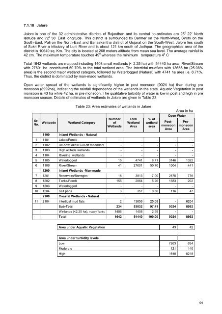
7.1.18 Jalore<br />
Jalore is one <strong>of</strong> the 32 administrative districts <strong>of</strong> Rajasthan <strong>and</strong> its central co-ordinates are 25 0 22’ North<br />
latitude <strong>and</strong> 72 0 58’ East longitude. This district is surrounded by Barmer on the North-West, Sirohi on the<br />
South-East, Pali on the North-East <strong>and</strong> Banaskantha district <strong>of</strong> Gujarat on the South-West. Jalore lies south<br />
<strong>of</strong> Sukri River a tributary <strong>of</strong> Luni River <strong>and</strong> is about 121 km south <strong>of</strong> Jodhpur. The geographical area <strong>of</strong> the<br />
district is 10640 sq. Km. The city is located at 268 meters altitude from mean sea level. The average rainfall is<br />
42 cm. The maximum temperature touches 49 0 whereas the minimum temperature 4 0 C .<br />
Total 1642 wetl<strong>and</strong>s are mapped including 1408 small wetl<strong>and</strong>s (< 2.25 ha) with 54440 ha area. River/Stream<br />
with 27601 ha. contributed 50.70% to the total wetl<strong>and</strong> area. The Intertidal mudflats with 13656 ha (25.08%<br />
area) is the second major wetl<strong>and</strong> category, followed by Waterlogged (Natural) with 4741 ha area i.e. 8.71%.<br />
Thus, the district is dominated by man-made wetl<strong>and</strong>s.<br />
Open water spread <strong>of</strong> the wetl<strong>and</strong>s is significantly higher in post monsoon (9024 ha) than during pre<br />
monsoon (8992ha), indicating the rainfall dependence <strong>of</strong> the wetl<strong>and</strong>s in the state. Aquatic Vegetation in post<br />
monsoon is 43 ha while 42 ha. in pre monsoon. The qualitative turbidity <strong>of</strong> water is low in post <strong>and</strong> high in pre<br />
monsoon season. Details <strong>of</strong> estimates <strong>of</strong> wetl<strong>and</strong>s in Jalore are given in Table 23.<br />
Table 23: Area estimates <strong>of</strong> wetl<strong>and</strong>s in Jalore<br />
Area in ha<br />
Sr.<br />
No.<br />
Wettcode<br />
Wetl<strong>and</strong> Category<br />
Number<br />
<strong>of</strong><br />
<strong>Wetl<strong>and</strong>s</strong><br />
Total<br />
Wetl<strong>and</strong><br />
Area<br />
% <strong>of</strong><br />
wetl<strong>and</strong><br />
area<br />
Open Water<br />
Postmonsoon<br />
Area<br />
Premonsoon<br />
Area<br />
1100 Inl<strong>and</strong> <strong>Wetl<strong>and</strong>s</strong> - Natural<br />
1 1101 Lakes/Ponds - - - - -<br />
2 1102 Ox-bow lakes/ Cut-<strong>of</strong>f me<strong>and</strong>ers - - - - -<br />
3 1103 High altitude wetl<strong>and</strong>s - - - - -<br />
4 1104 Riverine wetl<strong>and</strong>s - - - - -<br />
5 1105 Waterlogged 15 4741 8.71 3146 1322<br />
6 1106 River/Stream 41 27601 50.70 1504 441<br />
1200 Inl<strong>and</strong> <strong>Wetl<strong>and</strong>s</strong> -Man-made<br />
7 1201 Reservoirs/Barrages 18 3813 7.00 2675 776<br />
8 1202 Tanks/Ponds 155 2864 5.26 1583 202<br />
9 1203 Waterlogged - - - - -<br />
10 1204 Salt pans 3 357 0.66 116 47<br />
2100 Coastal <strong>Wetl<strong>and</strong>s</strong> - Natural<br />
11 2104 Intertidal mud flats 2 13656 25.08 - 6204<br />
Sub-Total 234 53032 97.41 9024 8992<br />
<strong>Wetl<strong>and</strong>s</strong> (


