

Wetlands Atlas - Ministry of Environment and Forests
Wetlands Atlas - Ministry of Environment and Forests
Wetlands Atlas - Ministry of Environment and Forests

Create successful ePaper yourself
Turn your PDF publications into a flip-book with our unique Google optimized e-Paper software.
7.1.30 Kota<br />
Kota is situated on the banks <strong>of</strong> the river Chambal. The administrative head quarter <strong>of</strong> the district is located at<br />
Kota <strong>and</strong> it the fifth largest city <strong>of</strong> Rajastthan. The central co-ordinates <strong>of</strong> the district head quarters are 25 0 18’<br />
North latitude <strong>and</strong> 76 0 23’ East longitude. The district is bounded on the north <strong>and</strong> north-west by Sawai<br />
Madhopur, Tonk <strong>and</strong> Bundi districts. The Chambal River separates these districts from Kota district. The<br />
geographical area <strong>of</strong> the district is 5446 sq. Km. The average rainfall is 89 cm. The maximum temperature<br />
touches 45 0 whereas the minimum temperature 9 0 C.<br />
Total 919 wetl<strong>and</strong>s are mapped including 680 small wetl<strong>and</strong>s (< 2.25 ha) with 16316 ha area. River/Stream<br />
with 10780 ha. contributed 66.07% to the total wetl<strong>and</strong> area. The Tanks/Ponds with 3171 ha (19.43% area) is<br />
the second major wetl<strong>and</strong> category, followed by Reservoirs/Barrages with 1238 ha area i.e. 7.59 %. Thus,<br />
the district is dominated by natural wetl<strong>and</strong>s.<br />
Open water spread <strong>of</strong> the wetl<strong>and</strong>s is significantly higher in post monsoon (10055 ha) than during pre<br />
monsoon (5709 ha), indicating the rainfall dependence <strong>of</strong> the wetl<strong>and</strong>s in the state. Aquatic vegetation in<br />
post-monsoon season is 140 ha <strong>and</strong> in Pre-monsoon, it is 177 ha. The qualitative turbidity <strong>of</strong> water is low in<br />
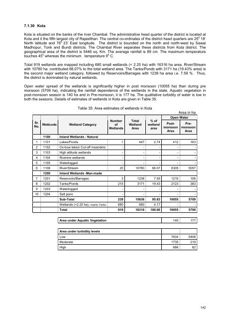
both the seasons. Details <strong>of</strong> estimates <strong>of</strong> wetl<strong>and</strong>s in Kota are given in Table 35.<br />
Table 35: Area estimates <strong>of</strong> wetl<strong>and</strong>s in Kota<br />
Area in ha<br />
Sr.<br />
No.<br />
Wettcode<br />
Wetl<strong>and</strong> Category<br />
Number<br />
<strong>of</strong><br />
<strong>Wetl<strong>and</strong>s</strong><br />
Total<br />
Wetl<strong>and</strong><br />
Area<br />
% <strong>of</strong><br />
wetl<strong>and</strong><br />
area<br />
Open Water<br />
Postmonsoon<br />
Area<br />
Premonsoon<br />
Area<br />
1100 Inl<strong>and</strong> <strong>Wetl<strong>and</strong>s</strong> - Natural<br />
1 1101 Lakes/Ponds 1 447 2.74 412 163<br />
2 1102 Ox-bow lakes/ Cut-<strong>of</strong>f me<strong>and</strong>ers - - - - -<br />
3 1103 High altitude wetl<strong>and</strong>s - - - - -<br />
4 1104 Riverine wetl<strong>and</strong>s - - - - -<br />
5 1105 Waterlogged - - - - -<br />
6 1106 River/Stream 20 10780 66.07 6305 5057<br />
1200 Inl<strong>and</strong> <strong>Wetl<strong>and</strong>s</strong> -Man-made<br />
7 1201 Reservoirs/Barrages 3 1238 7.59 1215 106<br />
8 1202 Tanks/Ponds 215 3171 19.43 2123 383<br />
9 1203 Waterlogged - - - - -<br />
10 1204 Salt pans - - - - -<br />
Sub-Total 239 15636 95.83 10055 5709<br />
<strong>Wetl<strong>and</strong>s</strong> (


