

Wetlands Atlas - Ministry of Environment and Forests
Wetlands Atlas - Ministry of Environment and Forests
Wetlands Atlas - Ministry of Environment and Forests

You also want an ePaper? Increase the reach of your titles
YUMPU automatically turns print PDFs into web optimized ePapers that Google loves.
7.1.29 Chittaurgarh<br />
Chittaugarh district is situated in the south-eastern part <strong>of</strong> the state <strong>of</strong> Rajasthan. It lies in between 25° 01’<br />
<strong>and</strong> 25° 58’ north latitude <strong>and</strong> 74° 01’ <strong>and</strong> 75° 28’ east longitude. The total geographical area <strong>of</strong> the district is<br />
10856 sq. kms. It is surrounded by Kota in the east <strong>and</strong> M<strong>and</strong>saur district <strong>of</strong> Madhya Pradesh <strong>and</strong> Banswara<br />
in the south-west, Udaipur <strong>and</strong> Rajsam<strong>and</strong> in the west <strong>and</strong> Bhilwara <strong>and</strong> Bundi in the north. Chittaugarh is a<br />
bustling industrial town in Rajasthan known for its Marble Industry, Cement Plants, Zinc Smelter <strong>and</strong><br />
Industrial Materials. The average rainfall is 85 cms. The maximum temperature reaches 45 0 while <strong>and</strong><br />
minimum temperature touches 7 0 C .<br />
Major tourist attractions in the district are Bassi Wildlife Sanctuary, Bhainsorgarh Wildlife Sanctuary, <strong>and</strong><br />
Sitamata Sanctuary.<br />
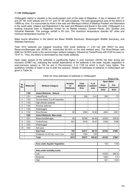
Total 1815 wetl<strong>and</strong>s are mapped including 1020 small wetl<strong>and</strong>s (< 2.25 ha) with 55537 ha area.<br />
Reservoirs/Barrages with 35786 ha. contributed 64.44% to the total wetl<strong>and</strong> area. The River/Stream with<br />
9360 ha (16.85% area) is the second major wetl<strong>and</strong> category, followed by Tanks/Ponds with 9145 ha area i.e.<br />
16.47 %. Thus, the district is dominated by man-made wetl<strong>and</strong>s.<br />
Open water spread <strong>of</strong> the wetl<strong>and</strong>s is significantly higher in post monsoon (45192 ha) than during pre<br />
monsoon (27867 ha), indicating the rainfall dependence <strong>of</strong> the wetl<strong>and</strong>s in the state. Aquatic vegetation in<br />
post-monsoon season is 126 ha <strong>and</strong> in Pre-monsoon, it is 1128 ha which is much more higher. The<br />
qualitative turbidity <strong>of</strong> water is low in both the seasons. Details <strong>of</strong> estimates <strong>of</strong> wetl<strong>and</strong>s in Chittaurgarh are<br />
given in Table 34.<br />
Sr.<br />
No.<br />
Wettcode<br />
Table 34: Area estimates <strong>of</strong> wetl<strong>and</strong>s in Chittaurgarh<br />
Wetl<strong>and</strong> Category<br />
Number<br />
<strong>of</strong><br />
<strong>Wetl<strong>and</strong>s</strong><br />
Total<br />
Wetl<strong>and</strong><br />
Area<br />
% <strong>of</strong><br />
wetl<strong>and</strong><br />
area<br />
Area in ha<br />
Open Water<br />
Postmonsoon<br />
Area<br />
Premonsoon<br />
Area<br />
1100 Inl<strong>and</strong> <strong>Wetl<strong>and</strong>s</strong> - Natural<br />
1 1101 Lakes/Ponds 3 226 0.41 205 70<br />
2 1102 Ox-bow lakes/ Cut-<strong>of</strong>f me<strong>and</strong>ers - - - - -<br />
3 1103 High altitude wetl<strong>and</strong>s - - - - -<br />
4 1104 Riverine wetl<strong>and</strong>s - - - - -<br />
5 1105 Waterlogged - - - - -<br />
6 1106 River/Stream 86 9360 16.85 4494 2091<br />
1200 Inl<strong>and</strong> <strong>Wetl<strong>and</strong>s</strong> -Man-made<br />
7 1201 Reservoirs/Barrages 65 35786 64.44 34333 23518<br />
8 1202 Tanks/Ponds 641 9145 16.47 6160 2188<br />
9 1203 Waterlogged - - - - -<br />
10 1204 Salt pans - - - - -<br />
Sub-Total 795 54517 98.16 45192 27867<br />
<strong>Wetl<strong>and</strong>s</strong> (


