

Wetlands Atlas - Ministry of Environment and Forests
Wetlands Atlas - Ministry of Environment and Forests
Wetlands Atlas - Ministry of Environment and Forests

You also want an ePaper? Increase the reach of your titles
YUMPU automatically turns print PDFs into web optimized ePapers that Google loves.
7.1.8 Dhaulpur<br />
Dhaulpur lies in between 26° 01’ <strong>and</strong> 26° 57’ north latitude <strong>and</strong> 74° 14’ <strong>and</strong> 78° 16’ east longitude. It is<br />
surrounded by Agra district in the north-east, Morena district <strong>of</strong> Madhya Pradesh in the south, Sawai<br />
Madhopur district in the west <strong>and</strong> Bharatpur district <strong>of</strong> Rajasthan in the north. The geographical area <strong>of</strong> the<br />
district is 3084 sq. kms. Some <strong>of</strong> the worth visiting places in <strong>and</strong> around the district are: Ramsagar Sanctuary,<br />
Talab-E-Shahi <strong>and</strong> Van Vihar Wild Life Sanctuary etc. The average rainfall is 67 cms. The maximum<br />
temperature reaches 49 0 while <strong>and</strong> minimum temperature touches 1 0 C .<br />
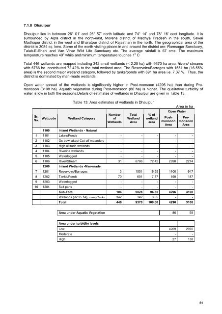
Total 446 wetl<strong>and</strong>s are mapped including 342 small wetl<strong>and</strong>s (< 2.25 ha) with 9370 ha area. Rivers/ streams<br />
with 6786 ha. contributed 72.42% to the total wetl<strong>and</strong> area. The Reservoirs/Barrages with 1551 ha (16.55%<br />
area) is the second major wetl<strong>and</strong> category, followed by tanks/ponds with 691 ha area i.e. 7.37 %. Thus, the<br />
district is dominated by man-made wetl<strong>and</strong>s.<br />
Open water spread <strong>of</strong> the wetl<strong>and</strong>s is significantly higher in Post-monsoon (4296 ha) than during Premonsoon<br />
(3108 ha). Aquatic vegetation during Post-monsoon (86 ha) is higher. The qualitative turbidity <strong>of</strong><br />
water is low in both the seasons.Details <strong>of</strong> estimates <strong>of</strong> wetl<strong>and</strong>s in Dhaulpur are given in Table 13.<br />
Table 13: Area estimates <strong>of</strong> wetl<strong>and</strong>s in Dhaulpur<br />
Area in ha<br />
Sr.<br />
No.<br />
Wettcode<br />
Wetl<strong>and</strong> Category<br />
Number<br />
<strong>of</strong><br />
<strong>Wetl<strong>and</strong>s</strong><br />
Total<br />
Wetl<strong>and</strong><br />
Area<br />
% <strong>of</strong><br />
wetl<strong>and</strong><br />
area<br />
Open Water<br />
Postmonsoon<br />
Area<br />
Premonsoon<br />
Area<br />
1100 Inl<strong>and</strong> <strong>Wetl<strong>and</strong>s</strong> - Natural<br />
1 1101 Lakes/Ponds - - - - -<br />
2 1102 Ox-bow lakes/ Cut-<strong>of</strong>f me<strong>and</strong>ers - - - - -<br />
3 1103 High altitude wetl<strong>and</strong>s - - - - -<br />
4 1104 Riverine wetl<strong>and</strong>s - - - - -<br />
5 1105 Waterlogged - - - - -<br />
6 1106 River/Stream 31 6786 72.42 2998 2274<br />
1200 Inl<strong>and</strong> <strong>Wetl<strong>and</strong>s</strong> -Man-made<br />
7 1201 Reservoirs/Barrages 3 1551 16.55 1100 647<br />
8 1202 Tanks/Ponds 70 691 7.37 198 187<br />
9 1203 Waterlogged - - - - -<br />
10 1204 Salt pans - - - - -<br />
Sub-Total 104 9028 96.35 4296 3108<br />
<strong>Wetl<strong>and</strong>s</strong> (


