

Wetlands Atlas - Ministry of Environment and Forests
Wetlands Atlas - Ministry of Environment and Forests
Wetlands Atlas - Ministry of Environment and Forests

You also want an ePaper? Increase the reach of your titles
YUMPU automatically turns print PDFs into web optimized ePapers that Google loves.
7.1.11 Dausa<br />
Dausa is located between 26° 54' to 27° 15' North latitude <strong>and</strong> 76° 38' to 76° 54' East longitude, covering an<br />
area <strong>of</strong> about 3429 sq.km The minimum <strong>and</strong> maximum temperature recorded is 3°C <strong>and</strong> 45°C respectively.<br />
The normal annual rainfall is 548.2 mm. Large part <strong>of</strong> the district is covered by a thick mantle <strong>of</strong> soil, blown<br />
s<strong>and</strong> <strong>and</strong> alluvium. The area is occupied by hill ranges <strong>and</strong> numerous isolated peaks These hills <strong>and</strong> peaks<br />
belong to the Aravalli hill system .<br />
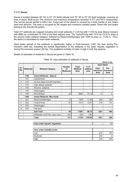
Total 317 wetl<strong>and</strong>s are mapped including 223 small wetl<strong>and</strong>s (< 2.25 ha) with 11720 ha area. Rivers/ streams<br />
with 8685 ha. contributed 74.10% to the total wetl<strong>and</strong> area. The Tanks/Ponds with 1513 ha (12.91% area) is<br />
the second major wetl<strong>and</strong> category, followed by Reservoirs/Barrages with 1299 ha area i.e. 11.08 %. Thus,<br />
the district is dominated by man-made wetl<strong>and</strong>s.<br />
Open water spread <strong>of</strong> the wetl<strong>and</strong>s is significantly higher in Post-monsoon (1281 ha) than during Premonsoon<br />
(485 ha), indicating the rainfall dependence <strong>of</strong> the wetl<strong>and</strong>s in the state. Aquatic vegetation is<br />
during Pre-monsoon season (22 ha). The qualitative turbidity <strong>of</strong> water is high in both the seasons.<br />
Details <strong>of</strong> estimates <strong>of</strong> wetl<strong>and</strong>s in Dausa are given in Table 16.<br />
Table 16: Area estimates <strong>of</strong> wetl<strong>and</strong>s in Dausa<br />
Area in ha<br />
Sr.<br />
No.<br />
Wettcode<br />
Wetl<strong>and</strong> Category<br />
Number<br />
<strong>of</strong><br />
<strong>Wetl<strong>and</strong>s</strong><br />
Total<br />
Wetl<strong>and</strong><br />
Area<br />
% <strong>of</strong><br />
wetl<strong>and</strong><br />
area<br />
Open Water<br />
Postmonsoon<br />
Area<br />
Premonsoon<br />
Area<br />
1100 Inl<strong>and</strong> <strong>Wetl<strong>and</strong>s</strong> - Natural<br />
1 1101 Lakes/Ponds - - - - -<br />
2 1102 Ox-bow lakes/ Cut-<strong>of</strong>f me<strong>and</strong>ers - - - - -<br />
3 1103 High altitude wetl<strong>and</strong>s - - - - -<br />
4 1104 Riverine wetl<strong>and</strong>s - - - - -<br />
5 1105 Waterlogged - - - - -<br />
6 1106 River/Stream 25 8685 74.10 13 4<br />
1200 Inl<strong>and</strong> <strong>Wetl<strong>and</strong>s</strong> -Man-made<br />
7 1201 Reservoirs/Barrages 12 1299 11.08 492 350<br />
8 1202 Tanks/Ponds 57 1513 12.91 776 131<br />
9 1203 Waterlogged - - - - -<br />
10 1204 Salt pans - - - - -<br />
Sub-Total 94 11497 98.10 1281 485<br />
<strong>Wetl<strong>and</strong>s</strong> (


