Report Cover Vol I - Clare County Library
Report Cover Vol I - Clare County Library
Report Cover Vol I - Clare County Library
You also want an ePaper? Increase the reach of your titles
YUMPU automatically turns print PDFs into web optimized ePapers that Google loves.
The <strong>County</strong> <strong>Clare</strong> Wetlands Survey Patrick Crushell & Peter Foss 2008<br />
____________________________________________________________________________________<br />
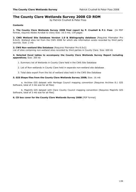
The <strong>County</strong> <strong>Clare</strong> Wetlands Survey 2008 CD ROM<br />
by Patrick Crushell & Peter Foss<br />
Contents<br />
1. The <strong>County</strong> <strong>Clare</strong> Wetlands Survey 2008 final report by P. Crushell & P.J. Foss (In PDF<br />
format, requires Adobe Acrobat to view) Size: 16.5 mb; 139 pages<br />
2. CWS Wetland Site Database Version 1.0 & Bibliography database (Requires Filemaker Pro<br />
8.0v2). Wetland sites list from the CWS 2008 for which site information exists recorded by third party<br />
sources. Size: 2 mb<br />
3. CWS Non-wetland Site Database (Requires Filemaker Pro 8.0v2)<br />
List of sites containing non-wetland sites recorded by third parties in <strong>County</strong> <strong>Clare</strong>. Size: 600 kb<br />
4. Selected Excel tables to accompany the <strong>County</strong> <strong>Clare</strong> Wetlands Survey <strong>Report</strong> including<br />
appendices; Size: 300 kb<br />
1. Summary list of Wetlands in <strong>County</strong> <strong>Clare</strong> held in the CWS Site Database<br />
2. List of Non-wetlands in <strong>County</strong> <strong>Clare</strong> held in separate non-wetland site database<br />
3. Total data export from the list of wetland sites held in the CWS Site Database<br />
5. GIS Shape files from the <strong>County</strong> <strong>Clare</strong> Wetlands Survey 2008; Size: 16 mb<br />
a. ArcView GIS dataset with Heritage Council mapping convention (Requires ArcView 8.1 GIS<br />
Software, total of 3 mb size for all files)<br />
b. MapInfo GIS dataset with <strong>Clare</strong> <strong>County</strong> Council mapping convention (Requires MapInfo GIS<br />
Software, total of 3 mb size for all files)<br />
6. CD box cover for the <strong>County</strong> <strong>Clare</strong> Wetlands Survey 2008 (PDF format)<br />
139


