

Report Cover Vol I - Clare County Library
Report Cover Vol I - Clare County Library
Report Cover Vol I - Clare County Library

Create successful ePaper yourself
Turn your PDF publications into a flip-book with our unique Google optimized e-Paper software.
The <strong>County</strong> <strong>Clare</strong> Wetlands Survey Patrick Crushell & Peter Foss 2008<br />
_______________________________________________________________<br />
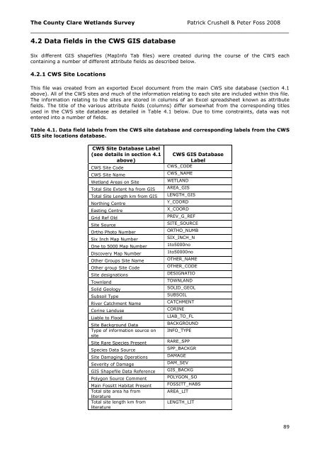
4.2 Data fields in the CWS GIS database<br />
Six different GIS shapefiles (MapInfo Tab files) were created during the course of the CWS each<br />
containing a number of different attribute fields as described below.<br />
4.2.1 CWS Site Locations<br />
This file was created from an exported Excel document from the main CWS site database (section 4.1<br />
above). All of the CWS sites and much of the information relating to each site are included within this file.<br />
The information relating to the sites are stored in columns of an Excel spreadsheet known as attribute<br />
fields. The title of the various attribute fields (columns) differ somewhat from the corresponding titles<br />
used in the CWS site database as detailed in Table 4.1 below. Due to time constraints, data was not<br />
entered into a number of fields.<br />
Table 4.1. Data field labels from the CWS site database and corresponding labels from the CWS<br />
GIS site locations database.<br />
CWS Site Database Label<br />
(see details in section 4.1<br />
above)<br />
CWS Site Code<br />
CWS Site Name<br />
Wetland Areas on Site<br />
Total Site Extent ha from GIS<br />
Total Site Length km from GIS<br />
Northing Centre<br />
Easting Centre<br />
Grid Ref Old<br />
Site Source<br />
Ortho Photo Number<br />
Six Inch Map Number<br />
One to 5000 Map Number<br />
Discovery Map Number<br />
Other Groups Site Name<br />
Other group Site Code<br />
Site designations<br />
Townland<br />
Solid Geology<br />
Subsoil Type<br />
River Catchment Name<br />
Corine Landuse<br />
Liable to Flood<br />
Site Background Data<br />
Type of information source on<br />
site<br />
Site Rare Species Present<br />
Species Data Source<br />
Site Damaging Operations<br />
Severity of Damage<br />
GIS Shapefile Data Reference<br />
Polygon Source Comment<br />
Main Fossitt Habitat Present<br />
Total site area ha from<br />
literature<br />
Total site length km from<br />
literature<br />
CWS GIS Database<br />
Label<br />
CWS_CODE<br />
CWS_NAME<br />
WETLAND<br />
AREA_GIS<br />
LENGTH_GIS<br />
Y_COORD<br />
X_COORD<br />
PREV_G_REF<br />
SITE_SOURCE<br />
ORTHO_NUMB<br />
SIX_INCH_N<br />
1to5000no<br />
1to50000no<br />
OTHER_NAME<br />
OTHER_CODE<br />
DESIGNATIO<br />
TOWNLAND<br />
SOLID_GEOL<br />
SUBSOIL<br />
CATCHMENT<br />
CORINE<br />
LIAB_TO_FL<br />
BACKGROUND<br />
INFO_TYPE<br />
RARE_SPP<br />
SPP_BACKGR<br />
DAMAGE<br />
DAM_SEV<br />
GIS_BACKG<br />
POLYGON_SO<br />
FOSSITT_HABS<br />
AREA_LIT<br />
LENGTH_LIT<br />
89


