

Report Cover Vol I - Clare County Library
Report Cover Vol I - Clare County Library
Report Cover Vol I - Clare County Library

You also want an ePaper? Increase the reach of your titles
YUMPU automatically turns print PDFs into web optimized ePapers that Google loves.
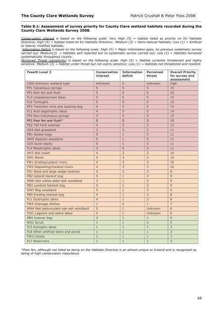
The <strong>County</strong> <strong>Clare</strong> Wetlands Survey Patrick Crushell & Peter Foss 2008<br />
____________________________________________________________________________________<br />
Table 8.1: Assessment of survey priority for <strong>County</strong> <strong>Clare</strong> wetland habitats recorded during the<br />
<strong>County</strong> <strong>Clare</strong> Wetlands Survey 2008.<br />
Conservation interest is based on the following scale: Very High (5) = habitat listed as priority on EU Habitats<br />
Directive; High (4) = habitat listed on EU Habitats Directive; Medium (3) = Semi-natural habitats; Low (1) = Artificial<br />
or heavily modified habitats.<br />
Information Deficit is based on the following scale: High (5) = Major information gaps, no previous systematic survey<br />
carried out; Medium(3) = Habitats well reported but no systematic survey carried out; Low (1) = Habitats Surveyed<br />
systematically throughout county.<br />
Perceived Threat (sensitivity) is based on the following scale. High (5) = Habitat currently threatened and highly<br />
sensitive; Medium (3) = Habitat under threat but not overly sensitive; Low (1) = Habitats not threatened and resilient.<br />
Fossitt Level 3<br />
Conservation<br />
interest<br />
Information<br />
deficit<br />
Perceived<br />
threat<br />
CWS Unknown wetland type Unknown 5 Unknown High<br />
FP1 Calcareous springs 5 5 5 15<br />
PF1 Rich fen and flush 5 5 5 15<br />
FL3 Limestone/marl lakes 5 5 5 15<br />
FL6 Turloughs 5 5 5 15<br />
PF3 Transition mire and quaking bog 4 5 5 14<br />
FL2 Acid oligotrophic lakes 4 5 5 14<br />
FP2 Non-Calcareous springs 3 5 5 13<br />
PF2 Poor fen and flush* 5 5 3 13<br />
FS2 Tall herb swamps 4 5 3 12<br />
GS4 Wet grassland 3 5 3 11<br />
PB1 Raised bogs 5 1 5 11<br />
WN5 Riparian woodland 5 1 5 11<br />
CD5 Dune slacks 5 1 5 11<br />
FL4 Mesotrophic lakes 3 5 3 11<br />
HH3 Wet heath 4 3 3 10<br />
GM1 Marsh 4 3 3 10<br />
FW1 Eroding/upland rivers 4 3 3 10<br />
FW2 Depositing/lowland rivers 4 3 3 10<br />
FS1 Reed and large sedge swamps 3 3 3 9<br />
PB2 Upland blanket bog 5 1 3 9<br />
WN6 Wet willow-alder-ash woodland 3 1 5 9<br />
PB3 Lowland blanket bog 5 1 3 9<br />
WN7 Bog woodland 5 1 3 9<br />
PB5 Eroding blanket bog 4 1 3 8<br />
FL1 Dystrophic lakes 4 1 3 8<br />
FW4 Drainage ditches 1 5 1 7<br />
WN4 Wet pedunculate oak-ash woodland 5 1 Unknown 6<br />
CW1 Lagoons and saline lakes 5 1 Unknown 6<br />
PB4 Cutover bog 3 1 1 5<br />
WS1 Scrub 1 1 3 5<br />
FL5 Eutrophic lakes 1 1 1 3<br />
FL8 Other artificial lakes and ponds 1 1 1 3<br />
FW3 Canals 1 1 1 3<br />
FL7 Reservoirs 1 1 1 3<br />
Overall Priority<br />
for survey and<br />
assessment<br />
*Poor fen, although not listed as being on the Habitats Directive is an almost unique to Ireland and is recognised as<br />
being of high conservation importance.<br />
69


