

Report Cover Vol I - Clare County Library
Report Cover Vol I - Clare County Library
Report Cover Vol I - Clare County Library

You also want an ePaper? Increase the reach of your titles
YUMPU automatically turns print PDFs into web optimized ePapers that Google loves.
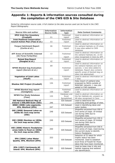
The <strong>County</strong> <strong>Clare</strong> Wetlands Survey Patrick Crushell & Peter Foss 2008<br />
_______________________________________________________________<br />
Appendix 1: <strong>Report</strong>s & information sources consulted during<br />
the compilation of the CWS GIS & Site Database<br />
Sorted by information source code. A full citation to the data sources used can be found in the CWS<br />
<strong>Report</strong> Bibliography.<br />
Information<br />
Source title and author Source Code<br />
IPCC Irish Fen Inventory<br />
(Crushell) 01<br />
Irish Peatland Conservation<br />
Council Action Plan (Foss et al.) 03<br />
Fergus Catchment <strong>Report</strong><br />
(Curtis et al.)<br />
AFF Areas of Scientific Interest<br />
(An Foras Forbartha)<br />
Raised Bog <strong>Report</strong><br />
(Douglas et al.) 42<br />
NPWS Blanket bog Evaluation<br />
report (Derwin et al.)<br />
Information<br />
type<br />
Published<br />
report<br />
Published<br />
report<br />
06 Published<br />
report<br />
12 Published<br />
89<br />
Vegetation of Irish Lakes<br />
(Heuff) 101<br />
Shadow SAC Project (Crushell)<br />
NPWS Blanket bog report<br />
(Conaghan) 108<br />
NPWS Fen Study Database<br />
(Foss)<br />
report<br />
Published<br />
report<br />
Published<br />
report<br />
Published<br />
report<br />
106 Published<br />
report<br />
155<br />
GSI National Bedrock Map of<br />
Ireland 1:500,000 Scale (GSI) 246<br />
SRBD (2008) Lake segments.<br />
EPA, Wexford (EPA) 247<br />
OSI (2008) Seasonal Lakes on<br />
1830s Six Inch map series<br />
(OSI)<br />
OSI (2008) Marshes on 1830s<br />
Six Inch map series (OSI)<br />
OSI (2008) Historic floodplains:<br />
areas liable to flood on 1830s<br />
Six Inch map series (OSI)<br />
EPA (2006) Lakes Water<br />
Quality. EPA, Wexford (EPA)<br />
EPA (1997) Catchments All<br />
Island. EPA, Wexford (EPA)<br />
248<br />
249<br />
250<br />
253<br />
Published<br />
report<br />
Database and<br />
Excel<br />
Spreadsheet<br />
GIS Dataset<br />
GIS Dataset<br />
GIS Dataset<br />
GIS Dataset<br />
GIS Dataset<br />
GIS Dataset<br />
255 GIS Dataset<br />
Data Content Comments<br />
Used to abstract information on<br />
sites<br />
Used to abstract information on<br />
34 sites<br />
Used to abstract information on<br />
the wetland habitats on 29 sites;<br />
9 new sites added to CWS<br />
database<br />
Used to abstract information on<br />
the wetland habitats etc. on 65<br />
sites recognised in <strong>Clare</strong> by AFF<br />
Used to abstract information on<br />
3 sites<br />
Used to abstract information on<br />
the wetland habitats and rare<br />
species; 1 new sites added to<br />
database. <strong>Report</strong> also contains<br />
specific areas of blanket bog on<br />
sites (not abstracted)<br />
Used to abstract information on<br />
7 sites<br />
Data import of wetland sites<br />
proposed by NGOs outside of<br />
NHA/SAC network; 1 new site<br />
added to CWS database<br />
Used to abstract information on<br />
1 site<br />
Used to abstract information on<br />
the fen habitats etc. present on<br />
48 sites recognised in <strong>Clare</strong><br />
Used to determine the<br />
underlying solid geology of sites.<br />
Used in Identifying lakes and<br />
water-bodies.<br />
Shapefile extracted from OSI 6<br />
Inch series of maps. Of limited<br />
use during CWS due to<br />
incomplete data.<br />
Shapefile extracted from OSI 6<br />
Inch series of maps. Of limited<br />
use during CWS due to<br />
incomplete data.<br />
Shapefile extracted from OSI 6<br />
Inch series of maps. Used during<br />
the current study to identify<br />
historic floodplains.<br />
Selection of 23 lakes for which<br />
trophic status has been<br />
monitored. Used to establish<br />
level three of Fossitt for those<br />
lakes that have been monitored.<br />
Used as base-map in site and<br />
habitat mapping and wetland<br />
site identification.<br />
76


