

Report Cover Vol I - Clare County Library
Report Cover Vol I - Clare County Library
Report Cover Vol I - Clare County Library

Create successful ePaper yourself
Turn your PDF publications into a flip-book with our unique Google optimized e-Paper software.
The <strong>County</strong> <strong>Clare</strong> Wetlands Survey Patrick Crushell & Peter Foss 2008<br />
_______________________________________________________________<br />
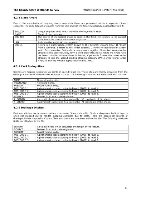
4.2.4 <strong>Clare</strong> Rivers<br />
Due to the complexity of mapping rivers accurately these are presented within a separate (linear)<br />
shapefile. The river dataset originates from the EPA and has the following attributes associated with it:<br />
SEG_CD<br />
NAME<br />
SOURCE<br />
LEN<br />
ORDER<br />
Unique segment code which identifies the segment of river.<br />
Name of river segment.<br />
The source of the habitat shape is given in this field, this relates to the dataset<br />
from which the habitat information originates.<br />
Refers to the length of river segment.<br />
Refers to a classification system known as the ‘Strahler’ stream order. It ranges<br />
from 1 upwards. 1 refers to first order streams, 2 refers to second-order stream<br />
which form when two first-order streams come together. When two second-order<br />
streams come together, they form a third-order stream etc. While the rivers have<br />
not been classified to level three in Fossitt, it generally follows that lower order<br />
streams fit into the upland eroding streams category (FW1) while higher order<br />
rivers fit into the lowland depositing streams (FW2).<br />
4.2.5 CWS Spring Sites<br />
Springs are mapped separately as points in an individual file. These sites are mainly extracted from the<br />
Geological Survey of Ireland Karst Features dataset. The following attributes are associated with this file:<br />
NAME<br />
Name of spring site.<br />
TOWNLAND<br />
Townland name.<br />
FOSSITT<br />
Fossitt habitat code.<br />
FOS_CODE_1 Alphanumeric code according to Fossitt (2000) to level 1.<br />
FOS_CODE_2 Alphanumeric code according to Fossitt (2000) to level 2.<br />
FOS_CODE_3 Alphanumeric code according to Fossitt (2000) to level 3.<br />
SOURCE<br />
Dataset from which site originated.<br />
X_COORD<br />
Automatically generated field giving the (X) coordinate of the shape.<br />
Y_COORD<br />
Automatically generated field giving the (Y) coordinate of the shape.<br />
4.2.6 Drainage Ditches<br />
Drainage ditches are presented within a separate (linear) shapefile. Such a ubiquitous habitat type is<br />
often not mapped during habitat mapping exercises due to scale. There are occasional records of<br />
drainage ditches mapped in <strong>County</strong> <strong>Clare</strong> and these are contained within this file. The following attribute<br />
fields are attached to the file:<br />
LENGTH<br />
Calculation field which calculates the length of the feature.<br />
SOURCE<br />
Dataset from which site originated.<br />
FOSSITT<br />
Fossitt habitat code.<br />
FOS_CODE_1 Alphanumeric code according to Fossitt (2000) to level 1.<br />
FOS_CODE_2 Alphanumeric code according to Fossitt (2000) to level 2.<br />
FOS_CODE_3 Alphanumeric code according to Fossitt (2000) to level 3.<br />
91


