

Report Cover Vol I - Clare County Library
Report Cover Vol I - Clare County Library
Report Cover Vol I - Clare County Library

You also want an ePaper? Increase the reach of your titles
YUMPU automatically turns print PDFs into web optimized ePapers that Google loves.
The <strong>County</strong> <strong>Clare</strong> Wetlands Survey Patrick Crushell & Peter Foss 2008<br />
_______________________________________________________________<br />
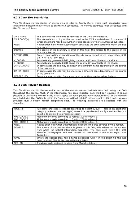
4.2.2 CWS Site Boundaries<br />
This file shows the boundaries of known wetland sites in <strong>County</strong> <strong>Clare</strong>, where such boundaries were<br />
available in digital format or could be drawn with confidence. The various attributes fields associated with<br />
this file are as follows:<br />
CWS NAME<br />
CWS CODE(s)<br />
AREA<br />
SOURCE<br />
DESIGNATIO<br />
X_COORD<br />
Y_COORD<br />
OTHER_NAME<br />
OTHER_CODE<br />
MERGED_BOU<br />
This contains the site name as recorded in the CWS site database.<br />
The site code according to that recorded in the CWS site database. In the case of<br />
larger sites there may be a number of site codes referring to numerous sub-sites.<br />
A calculation field which automatically calculates the area contained within the site<br />
boundary.<br />
The source of the boundary is given in this field, this relates to the source of the<br />
boundary feature.<br />
Nature conservation designations of the site are recorded within this attribute field<br />
(i.e. NHA, SAC, SPA etc.).<br />
Automatically generated field giving the central (X) coordinate of the shape.<br />
Automatically generated field giving the central (Y) coordinate of the shape.<br />
In some cases the site may be known by a different name depending on the source<br />
of the boundary.<br />
In some cases the site may be known by a different code depending on the source<br />
of the boundary.<br />
Boundary was compiled from a merge of more than one boundary feature.<br />
4.2.3 CWS Polygon Habitats<br />
This file shows the distribution and extent of the various wetland habitats recorded during the CWS<br />
throughout the county. Much of the information has been imported from third part sources. It is not<br />
possible to definitively confirm many habitat types by aerial photography therefore much of the wetland<br />
recorded during the CWS falls within the ‘unknown wetland habitat’ category, unless third party sources<br />
provided level 3 Fossitt habitat assignment data. The following attributes are associated with this<br />
shapefile:<br />
FOSSITT<br />
Full name and code of habitat according to Fossitt (2000). There is an additional<br />
category ‘unknown wetland type’, where it is possible to identify a wetland but not<br />
possible to assign it to a Fossitt category.<br />
FOS_CODE_1 Alphanumeric code according to Fossitt (2000) to level 1.<br />
FOS_CODE_2 Alphanumeric code according to Fossitt (2000) to level 2.<br />
FOS_CODE_3 Alphanumeric code according to Fossitt (2000) to level 3.<br />
AREA<br />
A calculation field which automatically calculates the area covered by the habitat.<br />
SOURCE<br />
The source of the habitat shape is given in this field, this relates to the dataset<br />
from which the habitat information originates. The code used within this field<br />
identifies bibliographic and GIS records as presented in the main report and<br />
Appendix 1.<br />
NAME<br />
Where the habitat area had a name associated with it in the origin file this has<br />
been retained. This is the case with many lakes.<br />
SEG_CD<br />
Individual code assigned to lakes from EPA lake dataset.<br />
90


