

Report Cover Vol I - Clare County Library
Report Cover Vol I - Clare County Library
Report Cover Vol I - Clare County Library

Create successful ePaper yourself
Turn your PDF publications into a flip-book with our unique Google optimized e-Paper software.
The <strong>County</strong> <strong>Clare</strong> Wetlands Survey Patrick Crushell & Peter Foss 2008<br />
____________________________________________________________________________________<br />
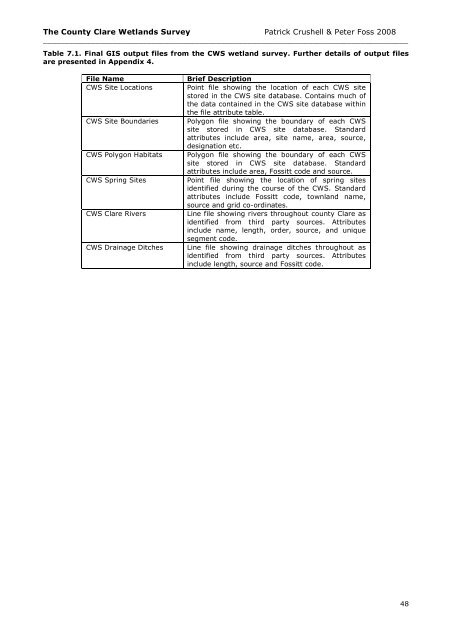
Table 7.1. Final GIS output files from the CWS wetland survey. Further details of output files<br />
are presented in Appendix 4.<br />
File Name<br />
CWS Site Locations<br />
CWS Site Boundaries<br />
CWS Polygon Habitats<br />
CWS Spring Sites<br />
CWS <strong>Clare</strong> Rivers<br />
CWS Drainage Ditches<br />
Brief Description<br />
Point file showing the location of each CWS site<br />
stored in the CWS site database. Contains much of<br />
the data contained in the CWS site database within<br />
the file attribute table.<br />
Polygon file showing the boundary of each CWS<br />
site stored in CWS site database. Standard<br />
attributes include area, site name, area, source,<br />
designation etc.<br />
Polygon file showing the boundary of each CWS<br />
site stored in CWS site database. Standard<br />
attributes include area, Fossitt code and source.<br />
Point file showing the location of spring sites<br />
identified during the course of the CWS. Standard<br />
attributes include Fossitt code, townland name,<br />
source and grid co-ordinates.<br />
Line file showing rivers throughout county <strong>Clare</strong> as<br />
identified from third party sources. Attributes<br />
include name, length, order, source, and unique<br />
segment code.<br />
Line file showing drainage ditches throughout as<br />
identified from third party sources. Attributes<br />
include length, source and Fossitt code.<br />
48


