

Report Cover Vol I - Clare County Library
Report Cover Vol I - Clare County Library
Report Cover Vol I - Clare County Library

You also want an ePaper? Increase the reach of your titles
YUMPU automatically turns print PDFs into web optimized ePapers that Google loves.
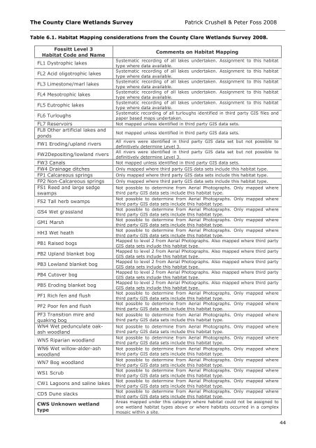
The <strong>County</strong> <strong>Clare</strong> Wetlands Survey Patrick Crushell & Peter Foss 2008<br />
____________________________________________________________________________________<br />
Table 6.1. Habitat Mapping considerations from the <strong>County</strong> <strong>Clare</strong> Wetlands Survey 2008.<br />
Fossitt Level 3<br />
Habitat Code and Name<br />
FL1 Dystrophic lakes<br />
FL2 Acid oligotrophic lakes<br />
FL3 Limestone/marl lakes<br />
FL4 Mesotrophic lakes<br />
FL5 Eutrophic lakes<br />
FL6 Turloughs<br />
FL7 Reservoirs<br />
FL8 Other artificial lakes and<br />
ponds<br />
FW1 Eroding/upland rivers<br />
FW2Depositing/lowland rivers<br />
FW3 Canals<br />
FW4 Drainage ditches<br />
FP1 Calcareous springs<br />
FP2 Non-Calcareous springs<br />
FS1 Reed and large sedge<br />
swamps<br />
FS2 Tall herb swamps<br />
GS4 Wet grassland<br />
GM1 Marsh<br />
HH3 Wet heath<br />
PB1 Raised bogs<br />
PB2 Upland blanket bog<br />
PB3 Lowland blanket bog<br />
PB4 Cutover bog<br />
PB5 Eroding blanket bog<br />
PF1 Rich fen and flush<br />
PF2 Poor fen and flush<br />
PF3 Transition mire and<br />
quaking bog<br />
WN4 Wet pedunculate oakash<br />
woodland<br />
WN5 Riparian woodland<br />
WN6 Wet willow-alder-ash<br />
woodland<br />
WN7 Bog woodland<br />
WS1 Scrub<br />
CW1 Lagoons and saline lakes<br />
CD5 Dune slacks<br />
CWS Unknown wetland<br />
type<br />
Comments on Habitat Mapping<br />
Systematic recording of all lakes undertaken. Assignment to this habitat<br />
type where data available.<br />
Systematic recording of all lakes undertaken. Assignment to this habitat<br />
type where data available.<br />
Systematic recording of all lakes undertaken. Assignment to this habitat<br />
type where data available.<br />
Systematic recording of all lakes undertaken. Assignment to this habitat<br />
type where data available.<br />
Systematic recording of all lakes undertaken. Assignment to this habitat<br />
type where data available.<br />
Systematic recording of all turloughs identified in third party GIS files and<br />
paper based maps undertaken.<br />
Not mapped unless identified in third party GIS data sets.<br />
Not mapped unless identified in third party GIS data sets.<br />
All rivers were identified in third party GIS data set but not possible to<br />
definitively determine Level 3.<br />
All rivers were identified in third party GIS data set but not possible to<br />
definitively determine Level 3.<br />
Not mapped unless identified in third party GIS data sets.<br />
Only mapped where third party GIS data sets include this habitat type.<br />
Only mapped where third party GIS data sets include this habitat type.<br />
Only mapped where third party GIS data sets include this habitat type.<br />
Not possible to determine from Aerial Photographs. Only mapped where<br />
third party GIS data sets include this habitat type.<br />
Not possible to determine from Aerial Photographs. Only mapped where<br />
third party GIS data sets include this habitat type.<br />
Not possible to determine from Aerial Photographs. Only mapped where<br />
third party GIS data sets include this habitat type.<br />
Not possible to determine from Aerial Photographs. Only mapped where<br />
third party GIS data sets include this habitat type.<br />
Not possible to determine from Aerial Photographs. Only mapped where<br />
third party GIS data sets include this habitat type.<br />
Mapped to level 2 from Aerial Photographs. Also mapped where third party<br />
GIS data sets include this habitat type.<br />
Mapped to level 2 from Aerial Photographs. Also mapped where third party<br />
GIS data sets include this habitat type.<br />
Mapped to level 2 from Aerial Photographs. Also mapped where third party<br />
GIS data sets include this habitat type.<br />
Mapped to level 2 from Aerial Photographs. Also mapped where third party<br />
GIS data sets include this habitat type.<br />
Mapped to level 2 from Aerial Photographs. Also mapped where third party<br />
GIS data sets include this habitat type.<br />
Not possible to determine from Aerial Photographs. Only mapped where<br />
third party GIS data sets include this habitat type.<br />
Not possible to determine from Aerial Photographs. Only mapped where<br />
third party GIS data sets include this habitat type.<br />
Not possible to determine from Aerial Photographs. Only mapped where<br />
third party GIS data sets include this habitat type.<br />
Not possible to determine from Aerial Photographs. Only mapped where<br />
third party GIS data sets include this habitat type.<br />
Not possible to determine from Aerial Photographs. Only mapped where<br />
third party GIS data sets include this habitat type.<br />
Not possible to determine from Aerial Photographs. Only mapped where<br />
third party GIS data sets include this habitat type.<br />
Not possible to determine from Aerial Photographs. Only mapped where<br />
third party GIS data sets include this habitat type.<br />
Not possible to determine from Aerial Photographs. Only mapped where<br />
third party GIS data sets include this habitat type.<br />
Not possible to determine from Aerial Photographs. Only mapped where<br />
third party GIS data sets include this habitat type.<br />
Not possible to determine from Aerial Photographs. Only mapped where<br />
third party GIS data sets include this habitat type.<br />
Areas mapped under this category where habitat could not be assigned to<br />
one wetland habitat types above or where habitats occurred in a complex<br />
mosaic within a site.<br />
44


