

Report Cover Vol I - Clare County Library
Report Cover Vol I - Clare County Library
Report Cover Vol I - Clare County Library

Create successful ePaper yourself
Turn your PDF publications into a flip-book with our unique Google optimized e-Paper software.
The <strong>County</strong> <strong>Clare</strong> Wetlands Survey Patrick Crushell & Peter Foss 2008<br />
____________________________________________________________________________________<br />
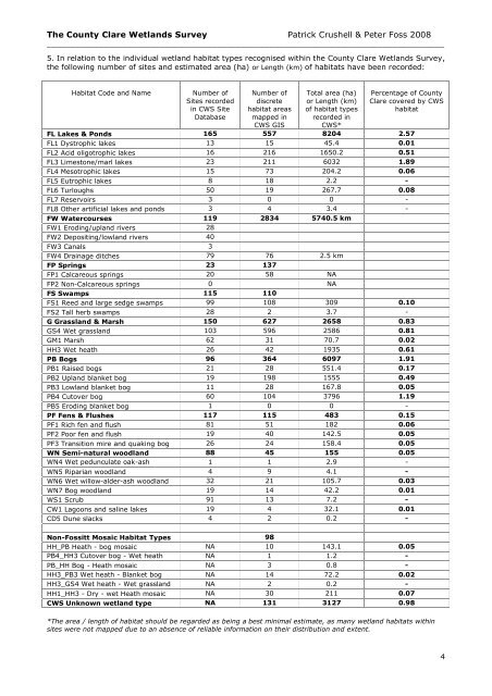
5. In relation to the individual wetland habitat types recognised within the <strong>County</strong> <strong>Clare</strong> Wetlands Survey,<br />
the following number of sites and estimated area (ha) or Length (km) of habitats have been recorded:<br />
Habitat Code and Name<br />
FL Lakes & Ponds<br />
Number of<br />
Sites recorded<br />
in CWS Site<br />
Database<br />
165<br />
Number of<br />
discrete<br />
habitat areas<br />
mapped in<br />
CWS GIS<br />
dataset 557<br />
Total area (ha)<br />
or Length (km)<br />
of habitat types<br />
recorded in<br />
CWS*<br />
8204 2.57<br />
FL1 Dystrophic lakes 13 15 45.4 0.01<br />
FL2 Acid oligotrophic lakes 16 216 1650.2 0.51<br />
FL3 Limestone/marl lakes 23 211 6032 1.89<br />
FL4 Mesotrophic lakes 15 73 204.2 0.06<br />
FL5 Eutrophic lakes 8 18 2.2 -<br />
FL6 Turloughs 50 19 267.7 0.08<br />
FL7 Reservoirs 3 0 0 -<br />
FL8 Other artificial lakes and ponds 3 4 3.4 -<br />
FW Watercourses 119 2834 5740.5 km<br />
FW1 Eroding/upland rivers 28<br />
FW2 Depositing/lowland rivers 40<br />
FW3 Canals 3<br />
FW4 Drainage ditches 79 76 2.5 km<br />
FP Springs 23 137<br />
FP1 Calcareous springs 20 58 NA<br />
FP2 Non-Calcareous springs 0 NA<br />
FS Swamps 115 110<br />
FS1 Reed and large sedge swamps 99 108 309 0.10<br />
FS2 Tall herb swamps 28 2 3.7 -<br />
G Grassland & Marsh 150 627 2658 0.83<br />
GS4 Wet grassland 103 596 2586 0.81<br />
GM1 Marsh 62 31 70.7 0.02<br />
HH3 Wet heath 26 42 1935 0.61<br />
PB Bogs 96 364 6097 1.91<br />
PB1 Raised bogs 21 28 551.4 0.17<br />
PB2 Upland blanket bog 19 198 1555 0.49<br />
PB3 Lowland blanket bog 11 28 167.8 0.05<br />
PB4 Cutover bog 60 104 3796 1.19<br />
PB5 Eroding blanket bog 1 0 0 -<br />
PF Fens & Flushes 117 115 483 0.15<br />
PF1 Rich fen and flush 81 51 182 0.06<br />
PF2 Poor fen and flush 19 40 142.5 0.05<br />
PF3 Transition mire and quaking bog 26 24 158.4 0.05<br />
WN Semi-natural woodland 88 45 155 0.05<br />
WN4 Wet pedunculate oak-ash<br />
1 1 2.9 -<br />
woodland<br />
Percentage of <strong>County</strong><br />
<strong>Clare</strong> covered by CWS<br />
habitat<br />
WN5 Riparian woodland 4 9 4.1 -<br />
WN6 Wet willow-alder-ash woodland 32 21 105.7 0.03<br />
WN7 Bog woodland 19 14 42.2 0.01<br />
WS1 Scrub 91 13 7.2 -<br />
CW1 Lagoons and saline lakes 19 4 32.1 0.01<br />
CD5 Dune slacks 4 2 0.2 -<br />
Non-Fossitt Mosaic Habitat Types 98<br />
HH_PB Heath - bog mosaic NA 10 143.1 0.05<br />
PB4_HH3 Cutover bog - Wet heath<br />
NA 1 1.2 -<br />
mosaic PB_HH Bog - Heath mosaic NA 3 0.8 -<br />
HH3_PB3 Wet heath - Blanket bog<br />
NA 14 72.2 0.02<br />
mosaic HH3_GS4 Wet heath - Wet grassland<br />
NA 2 0.2 -<br />
mosaic HH1_HH3 - Dry - wet Heath mosaic NA 30 211 0.07<br />
CWS Unknown wetland type NA 131 3127 0.98<br />
*The area / length of habitat should be regarded as being a best minimal estimate, as many wetland habitats within<br />
sites were not mapped due to an absence of reliable information on their distribution and extent.<br />
4


