

Report Cover Vol I - Clare County Library
Report Cover Vol I - Clare County Library
Report Cover Vol I - Clare County Library

Create successful ePaper yourself
Turn your PDF publications into a flip-book with our unique Google optimized e-Paper software.
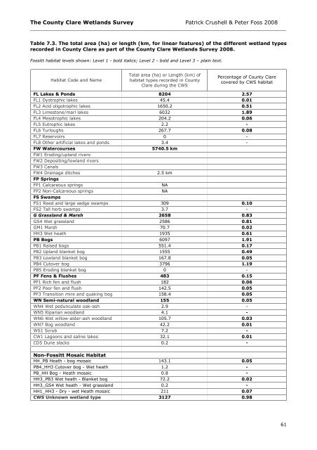
The <strong>County</strong> <strong>Clare</strong> Wetlands Survey Patrick Crushell & Peter Foss 2008<br />
____________________________________________________________________________________<br />
Table 7.3. The total area (ha) or length (km, for linear features) of the different wetland types<br />
recorded in <strong>County</strong> <strong>Clare</strong> as part of the <strong>County</strong> <strong>Clare</strong> Wetlands Survey 2008.<br />
Fossitt habitat levels shown: Level 1 - bold italics; Level 2 - bold and Level 3 – plain text.<br />
Habitat Code and Name<br />
Total area (ha) or Length (km) of<br />
habitat types recorded in <strong>County</strong><br />
<strong>Clare</strong> during the CWS<br />
Percentage of <strong>County</strong> <strong>Clare</strong><br />
covered by CWS habitat<br />
FL Lakes & Ponds 8204 2.57<br />
FL1 Dystrophic lakes 45.4 0.01<br />
FL2 Acid oligotrophic lakes 1650.2 0.51<br />
FL3 Limestone/marl lakes 6032 1.89<br />
FL4 Mesotrophic lakes 204.2 0.06<br />
FL5 Eutrophic lakes 2.2 -<br />
FL6 Turloughs 267.7 0.08<br />
FL7 Reservoirs 0 -<br />
FL8 Other artificial lakes and ponds 3.4 -<br />
FW Watercourses<br />
5740.5 km<br />
FW1 Eroding/upland rivers<br />
FW2 Depositing/lowland rivers<br />
FW3 Canals<br />
FW4 Drainage ditches<br />
2.5 km<br />
FP Springs<br />
FP1 Calcareous springs<br />
NA<br />
FP2 Non-Calcareous springs<br />
NA<br />
FS Swamps<br />
FS1 Reed and large sedge swamps 309 0.10<br />
FS2 Tall herb swamps 3.7 -<br />
G Grassland & Marsh 2658 0.83<br />
GS4 Wet grassland 2586 0.81<br />
GM1 Marsh 70.7 0.02<br />
HH3 Wet heath 1935 0.61<br />
PB Bogs 6097 1.91<br />
PB1 Raised bogs 551.4 0.17<br />
PB2 Upland blanket bog 1555 0.49<br />
PB3 Lowland blanket bog 167.8 0.05<br />
PB4 Cutover bog 3796 1.19<br />
PB5 Eroding blanket bog 0 -<br />
PF Fens & Flushes 483 0.15<br />
PF1 Rich fen and flush 182 0.06<br />
PF2 Poor fen and flush 142.5 0.05<br />
PF3 Transition mire and quaking bog 158.4 0.05<br />
WN Semi-natural woodland 155 0.05<br />
WN4 Wet pedunculate oak-ash<br />
2.9 -<br />
woodland WN5 Riparian woodland 4.1 -<br />
WN6 Wet willow-alder-ash woodland 105.7 0.03<br />
WN7 Bog woodland 42.2 0.01<br />
WS1 Scrub 7.2 -<br />
CW1 Lagoons and saline lakes 32.1 0.01<br />
CD5 Dune slacks 0.2 -<br />
Non-Fossitt Mosaic Habitat<br />
Types HH_PB Heath - bog mosaic 143.1 0.05<br />
PB4_HH3 Cutover bog - Wet heath<br />
1.2 -<br />
mosaic PB_HH Bog - Heath mosaic 0.8 -<br />
HH3_PB3 Wet heath - Blanket bog<br />
72.2 0.02<br />
mosaic HH3_GS4 Wet heath - Wet grassland<br />
0.2 -<br />
mosaic HH1_HH3 - Dry - wet Heath mosaic 211 0.07<br />
CWS Unknown wetland type 3127 0.98<br />
61


