

Report Cover Vol I - Clare County Library
Report Cover Vol I - Clare County Library
Report Cover Vol I - Clare County Library

Create successful ePaper yourself
Turn your PDF publications into a flip-book with our unique Google optimized e-Paper software.
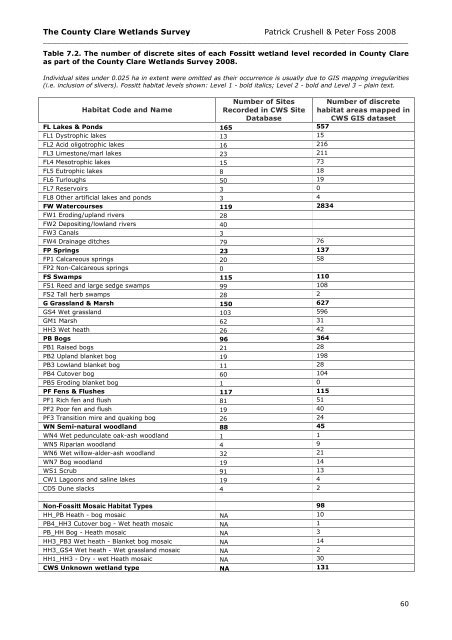
The <strong>County</strong> <strong>Clare</strong> Wetlands Survey Patrick Crushell & Peter Foss 2008<br />
____________________________________________________________________________________<br />
Table 7.2. The number of discrete sites of each Fossitt wetland level recorded in <strong>County</strong> <strong>Clare</strong><br />
as part of the <strong>County</strong> <strong>Clare</strong> Wetlands Survey 2008.<br />
Individual sites under 0.025 ha in extent were omitted as their occurrence is usually due to GIS mapping irregularities<br />
(i.e. inclusion of slivers). Fossitt habitat levels shown: Level 1 - bold italics; Level 2 - bold and Level 3 – plain text.<br />
Habitat Code and Name<br />
Number of Sites<br />
Recorded in CWS Site<br />
Database<br />
FL Lakes & Ponds 165 557<br />
FL1 Dystrophic lakes 13 15<br />
FL2 Acid oligotrophic lakes 16 216<br />
FL3 Limestone/marl lakes 23 211<br />
FL4 Mesotrophic lakes 15 73<br />
FL5 Eutrophic lakes 8 18<br />
FL6 Turloughs 50 19<br />
FL7 Reservoirs 3 0<br />
FL8 Other artificial lakes and ponds 3 4<br />
FW Watercourses 119 2834<br />
FW1 Eroding/upland rivers 28<br />
FW2 Depositing/lowland rivers 40<br />
FW3 Canals 3<br />
FW4 Drainage ditches 79 76<br />
FP Springs 23 137<br />
FP1 Calcareous springs 20 58<br />
FP2 Non-Calcareous springs 0<br />
FS Swamps 115 110<br />
FS1 Reed and large sedge swamps 99 108<br />
FS2 Tall herb swamps 28 2<br />
G Grassland & Marsh 150 627<br />
GS4 Wet grassland 103 596<br />
GM1 Marsh 62 31<br />
HH3 Wet heath 26 42<br />
PB Bogs 96 364<br />
PB1 Raised bogs 21 28<br />
PB2 Upland blanket bog 19 198<br />
PB3 Lowland blanket bog 11 28<br />
PB4 Cutover bog 60 104<br />
PB5 Eroding blanket bog 1 0<br />
PF Fens & Flushes 117 115<br />
PF1 Rich fen and flush 81 51<br />
PF2 Poor fen and flush 19 40<br />
PF3 Transition mire and quaking bog 26 24<br />
WN Semi-natural woodland 88 45<br />
WN4 Wet pedunculate oak-ash woodland 1 1<br />
WN5 Riparian woodland 4 9<br />
WN6 Wet willow-alder-ash woodland 32 21<br />
WN7 Bog woodland 19 14<br />
WS1 Scrub 91 13<br />
CW1 Lagoons and saline lakes 19 4<br />
CD5 Dune slacks 4 2<br />
Non-Fossitt Mosaic Habitat Types 98<br />
HH_PB Heath - bog mosaic NA 10<br />
PB4_HH3 Cutover bog - Wet heath mosaic NA 1<br />
PB_HH Bog - Heath mosaic NA 3<br />
HH3_PB3 Wet heath - Blanket bog mosaic NA 14<br />
HH3_GS4 Wet heath - Wet grassland mosaic NA 2<br />
HH1_HH3 - Dry - wet Heath mosaic NA 30<br />
CWS Unknown wetland type NA 131<br />
Number of discrete<br />
habitat areas mapped in<br />
CWS GIS dataset<br />
60


