

Report Cover Vol I - Clare County Library
Report Cover Vol I - Clare County Library
Report Cover Vol I - Clare County Library

Create successful ePaper yourself
Turn your PDF publications into a flip-book with our unique Google optimized e-Paper software.
The <strong>County</strong> <strong>Clare</strong> Wetlands Survey Patrick Crushell & Peter Foss 2008<br />
____________________________________________________________________________________<br />
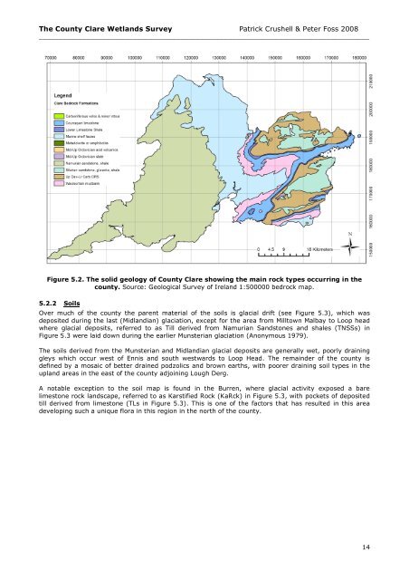
Figure 5.2. The solid geology of <strong>County</strong> <strong>Clare</strong> showing the main rock types occurring in the<br />
county. Source: Geological Survey of Ireland 1:500000 bedrock map.<br />
5.2.2 Soils<br />
Over much of the county the parent material of the soils is glacial drift (see Figure 5.3), which was<br />
deposited during the last (Midlandian) glaciation, except for the area from Milltown Malbay to Loop head<br />
where glacial deposits, referred to as Till derived from Namurian Sandstones and shales (TNSSs) in<br />
Figure 5.3 were laid down during the earlier Munsterian glaciation (Anonymous 1979).<br />
The soils derived from the Munsterian and Midlandian glacial deposits are generally wet, poorly draining<br />
gleys which occur west of Ennis and south westwards to Loop Head. The remainder of the county is<br />
defined by a mosaic of better drained podzolics and brown earths, with poorer draining soil types in the<br />
upland areas in the east of the county adjoining Lough Derg.<br />
A notable exception to the soil map is found in the Burren, where glacial activity exposed a bare<br />
limestone rock landscape, referred to as Karstified Rock (KaRck) in Figure 5.3, with pockets of deposited<br />
till derived from limestone (TLs in Figure 5.3). This is one of the factors that has resulted in this area<br />
developing such a unique flora in this region in the north of the county.<br />
14


