A Management Strategy for Oneida Lake and its ... - CNY RPDB Home
A Management Strategy for Oneida Lake and its ... - CNY RPDB Home
A Management Strategy for Oneida Lake and its ... - CNY RPDB Home
You also want an ePaper? Increase the reach of your titles
YUMPU automatically turns print PDFs into web optimized ePapers that Google loves.
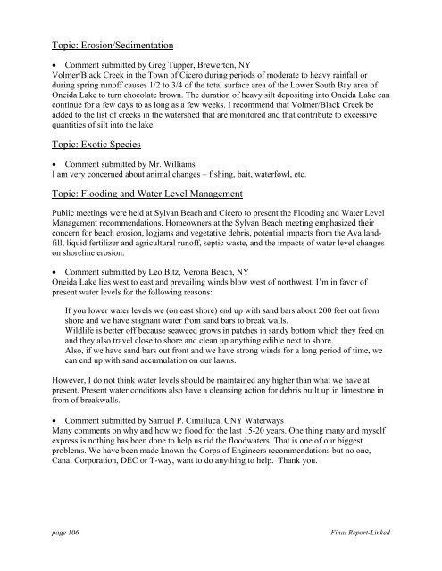
Topic: Erosion/Sedimentation<br />
• Comment submitted by Greg Tupper, Brewerton, NY<br />
Volmer/Black Creek in the Town of Cicero during periods of moderate to heavy rainfall or<br />
during spring runoff causes 1/2 to 3/4 of the total surface area of the Lower South Bay area of<br />
<strong>Oneida</strong> <strong>Lake</strong> to turn chocolate brown. The duration of heavy silt depositing into <strong>Oneida</strong> <strong>Lake</strong> can<br />
continue <strong>for</strong> a few days to as long as a few weeks. I recommend that Volmer/Black Creek be<br />
added to the list of creeks in the watershed that are monitored <strong>and</strong> that contribute to excessive<br />
quantities of silt into the lake.<br />
Topic: Exotic Species<br />
• Comment submitted by Mr. Williams<br />
I am very concerned about animal changes – fishing, bait, waterfowl, etc.<br />
Topic: Flooding <strong>and</strong> Water Level <strong>Management</strong><br />
Public meetings were held at Sylvan Beach <strong>and</strong> Cicero to present the Flooding <strong>and</strong> Water Level<br />
<strong>Management</strong> recommendations. <strong>Home</strong>owners at the Sylvan Beach meeting emphasized their<br />
concern <strong>for</strong> beach erosion, logjams <strong>and</strong> vegetative debris, potential impacts from the Ava l<strong>and</strong>fill,<br />
liquid fertilizer <strong>and</strong> agricultural runoff, septic waste, <strong>and</strong> the impacts of water level changes<br />
on shoreline erosion.<br />
• Comment submitted by Leo Bitz, Verona Beach, NY<br />
<strong>Oneida</strong> <strong>Lake</strong> lies west to east <strong>and</strong> prevailing winds blow west of northwest. I’m in favor of<br />
present water levels <strong>for</strong> the following reasons:<br />
If you lower water levels we (on east shore) end up with s<strong>and</strong> bars about 200 feet out from<br />
shore <strong>and</strong> we have stagnant water from s<strong>and</strong> bars to break walls.<br />
Wildlife is better off because seaweed grows in patches in s<strong>and</strong>y bottom which they feed on<br />
<strong>and</strong> they also travel close to shore <strong>and</strong> clean up anything edible next to shore.<br />
Also, if we have s<strong>and</strong> bars out front <strong>and</strong> we have strong winds <strong>for</strong> a long period of time, we<br />
can end up with s<strong>and</strong> accumulation on our lawns.<br />
However, I do not think water levels should be maintained any higher than what we have at<br />
present. Present water conditions also have a cleansing action <strong>for</strong> debris built up in limestone in<br />
from of breakwalls.<br />
• Comment submitted by Samuel P. Cimilluca, <strong>CNY</strong> Waterways<br />
Many comments on why <strong>and</strong> how we flood <strong>for</strong> the last 15-20 years. One thing many <strong>and</strong> myself<br />
express is nothing has been done to help us rid the floodwaters. That is one of our biggest<br />
problems. We have been made known the Corps of Engineers recommendations but no one,<br />
Canal Corporation, DEC or T-way, want to do anything to help. Thank you.<br />
page 106<br />
Final Report-Linked


