A Management Strategy for Oneida Lake and its ... - CNY RPDB Home
A Management Strategy for Oneida Lake and its ... - CNY RPDB Home
A Management Strategy for Oneida Lake and its ... - CNY RPDB Home

You also want an ePaper? Increase the reach of your titles
YUMPU automatically turns print PDFs into web optimized ePapers that Google loves.
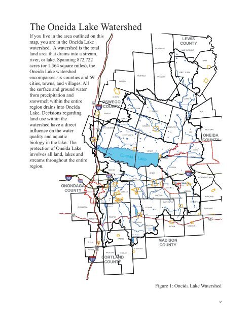
The <strong>Oneida</strong> <strong>Lake</strong> Watershed<br />
If you live in the area outlined on this<br />
map, you are in the <strong>Oneida</strong> <strong>Lake</strong><br />
watershed. A watershed is the total<br />
l<strong>and</strong> area that drains into a stream,<br />
river, or lake. Spanning 872,722<br />
acres (or 1,364 square miles), the<br />
<strong>Oneida</strong> <strong>Lake</strong> watershed<br />
encompasses six counties <strong>and</strong> 69<br />
cities, towns, <strong>and</strong> villages. All<br />
the surface <strong>and</strong> ground water<br />
from precipitation <strong>and</strong><br />
snowmelt within the entire<br />
region drains into <strong>Oneida</strong><br />
<strong>Lake</strong>. Decisions regarding<br />
l<strong>and</strong> use within the<br />
watershed have a direct<br />
influence on the water<br />
quality <strong>and</strong> aquatic<br />
biology in the lake. The<br />
protection of <strong>Oneida</strong> <strong>Lake</strong><br />
involves all l<strong>and</strong>, lakes <strong>and</strong><br />
streams throughout the entire<br />
region.<br />
90<br />
ONONDAGA<br />
COUNTY<br />
ONONDAGA<br />
SYRACUSE<br />
81<br />
HASTINGS<br />
Central Square<br />
LAFAYETTE<br />
OSWEGO<br />
COUNTY<br />
Butternu<br />
t Creek<br />
DEWITT<br />
PARISH<br />
WEST MONROE<br />
CICERO<br />
Minoa<br />
East Syracuse<br />
Jamesville<br />
Reservoir<br />
ALBION<br />
reek<br />
Limestone C<br />
POMPEY<br />
Scriba Cree<br />
ORWELL<br />
Chase Pond<br />
k<br />
Kasoag <strong>Lake</strong><br />
Panther <strong>Lake</strong><br />
CONSTANTIA<br />
V<strong>and</strong>ercamp Pond<br />
Little River<br />
<strong>Oneida</strong> <strong>Lake</strong><br />
MANILUS<br />
Fayetteville<br />
Manlius<br />
AMBOY<br />
WILLIAMSTOWN<br />
Clevel<strong>and</strong><br />
SULLIVAN<br />
REDFIELD<br />
Chittenango<br />
Cazenovia <strong>Lake</strong><br />
CAZENOVIA<br />
Canaseraga Creek<br />
o Creek<br />
Chittenag<br />
Mad River<br />
West Branch Fish Creek<br />
CAMDEN<br />
Cazenovia<br />
VIENNA<br />
LENOX<br />
FENNER<br />
NELSON<br />
FLORENCE<br />
Tuscaora<br />
<strong>Lake</strong><br />
Camden<br />
Canastota<br />
ta Creek<br />
Canast o<br />
MONTAGUE<br />
OSCEOLA<br />
LINCOLN<br />
ANNSVILLE<br />
Fish Creek<br />
Sylvan Beach<br />
VERONA<br />
O n eida Cre e<br />
k<br />
E. Branch Fish Creek<br />
Wood Cree<br />
<strong>Oneida</strong><br />
Wampsville Castle<br />
SHERRILL<br />
ONEIDA<br />
EATON<br />
LEWIS<br />
COUNTY<br />
MARTINSBURG<br />
WEST TURIN<br />
k<br />
LEWIS<br />
Sconon doa Creek<br />
STOCKBRIDGE<br />
SMITHFIELD<br />
Bloodsucker <strong>Lake</strong><br />
Munnsville<br />
90<br />
LEE<br />
VERNON<br />
Canada Creek<br />
ROME<br />
Erie Canal<br />
Vernon<br />
AUGUSTA<br />
MADISON<br />
AVA<br />
TURIN<br />
WESTERN<br />
ONEIDA<br />
COUNTY<br />
WESTMORELAND<br />
KIRKLAND<br />
MARSHALL<br />
TULLY<br />
PREBLE<br />
81<br />
TRUXTON<br />
FABIUS<br />
CUYLER<br />
CORTLAND<br />
COUNTY<br />
De Ruyter<br />
Reservoir<br />
DE RUYTER<br />
MADISON<br />
COUNTY<br />
Figure 1: <strong>Oneida</strong> <strong>Lake</strong> Watershed<br />
v