SIBER SPIS sept 2011.pdf - IMBER
SIBER SPIS sept 2011.pdf - IMBER
SIBER SPIS sept 2011.pdf - IMBER

You also want an ePaper? Increase the reach of your titles
YUMPU automatically turns print PDFs into web optimized ePapers that Google loves.
<strong>SIBER</strong><br />
Science Plan and Implementation Strategy<br />
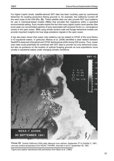
For higher trophic levels, satellite-derived SST data has been routinely used by commercial<br />
fishermen for locating productive fishing grounds in, for example, the California Current off<br />
the west coast of the USA (Fig. 22). These satellite data can also provide SST input patterns<br />
for use in individual-based models (IBMs) that simulate fish migrations within a specified<br />
environmental setting. Such models exploit the fact that many higher trophic level species (like<br />
tuna) seek out concentrated patches of prey associated with physical fronts (i.e. convergence<br />
zones) in the open ocean. IBMs using simple random walk and forage behavioral models can<br />
provide important insights into how large predators migrate in the open ocean.<br />
It has also been shown that ocean color patterns can be related to CPUE of the tuna fishery<br />
in IO equatorial waters. In particular, Marsac et al. (2006) identified a clear relation between<br />
SeaWiFS-observed chlorophyll and CPUE distributional shifts during IOD events. Thus, ocean<br />
color data could potentially be combined with SST data to provide not only behavioral clues,<br />
but also as guidance on the location of optimal foraging grounds as tuna populations move<br />
zonally in equatorial waters under changing climatic conditions.<br />
Fi g u r e 22 Central California (USA) daily albacore tuna catches, September 27 to October 2, 1981,<br />
and sea surface temperature from NOAA 7 AVHRR, channels 4 and 5, September 30, 1981.<br />
Figure and caption reproduced with permission from Njoku et al. (1985).<br />
51