SIBER SPIS sept 2011.pdf - IMBER
SIBER SPIS sept 2011.pdf - IMBER
SIBER SPIS sept 2011.pdf - IMBER

Create successful ePaper yourself
Turn your PDF publications into a flip-book with our unique Google optimized e-Paper software.
<strong>SIBER</strong><br />
Science Plan and Implementation Strategy<br />
basic variables, derived quantities, such as latent and sensible heat, net surface radiation,<br />
penetrative shortwave radiation, mixed-layer depth, ocean density, and dynamic height (the<br />
baroclinic component of sea level) can be computed. Thus, the mooring-based measurements<br />
can provide an excellent atmospheric and physical oceanographic observational foundation<br />
for carrying out a wide variety of biogeochemical and ecological studies.<br />
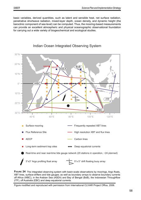
Indian Ocean Integrated Observing System<br />
30°N<br />
20°N<br />
WAST<br />
NEAST<br />
ASEA<br />
BoB<br />
10°N<br />
WBC<br />
0°<br />
WBC<br />
10°S<br />
20°S<br />
30°S<br />
ITF<br />
WBC<br />
EBC<br />
40°E 60°E 80°E 100°E 120°E<br />
Surface mooring<br />
Flux Reference Site<br />
ADCP<br />
Frequently repeated XBT lines<br />
High resolution XBT and flux lines<br />
Carbon lines<br />
Long-term sediment trap sites<br />
Deep equatorial currents<br />
Real-time and near real-time tide gauge network (20 stations in operation, ~24 planned)<br />
3°x3° Argo profiling float array<br />
5°x 5° drift floating buoy array<br />
Fi g u r e 24 The integrated observing system with basin-scale observations by moorings, Argo floats,<br />
XBT lines, surface-drifters and tide gauges; as well as boundary arrays to observe boundary currents<br />
off Africa (WBC), in the Arabian Sea (ASEA) and Bay of Bengal (BoB), the Indonesian Throughflow<br />
(ITF), off Australia (EBC) and deep equatorial currents.<br />
Figure modified and reproduced with permission from International CLIVAR Project Office, 2006.<br />
58