Highway Slope Manual
Highway Slope Manual
Highway Slope Manual
Create successful ePaper yourself
Turn your PDF publications into a flip-book with our unique Google optimized e-Paper software.
-AA<br />
(v)<br />
relevant services and utilities records.<br />
(b)<br />
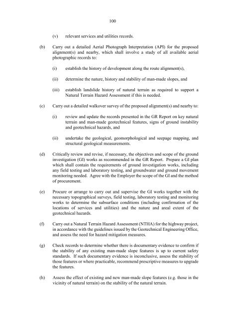
Carry out a detailed Aerial Photograph 1nterpretation (AP1) for the proposed<br />
alignment(s) and nearby, which shall involve a study of all available aerial<br />
photographic records to:<br />
(i)<br />
(ii)<br />
(iii)<br />
establish the history of development along the route alignment(s),<br />
determine the nature, history and stability of man-made slopes, and<br />
establish landslide history of natural terrain as required to support a<br />
Natural Terrain Hazard Assessment if this is needed.<br />
(c)<br />
Carry out a detailed walkover survey of the proposed alignment(s) and nearby to:<br />
(i)<br />
(ii)<br />
review and update the records presented in the GR Report on key natural<br />
terrain and man-made geotechnical features, signs of ground instability<br />
and geotechnical hazards, and<br />
undertake the geological, geomorphological and seepage mapping, and<br />
structural geological measurements.<br />
(d)<br />
(e)<br />
(f)<br />
(g)<br />
(h)<br />
Critically review and revise, if necessary, the objectives and scope of the ground<br />
investigation (G1) works as recommended in the GR Report. Prepare a G1 plan<br />
which shall contain the requirements of ground investigation works, including<br />
any field testing and laboratory testing, and groundwater and ground movement<br />
monitoring needed. Agree with the Employer the scope of the G1 and the method<br />
of procurement.<br />
Procure or arrange to carry out and supervise the G1 works together with the<br />
necessary topographical surveys, field testing, laboratory testing and monitoring<br />
works to determine the subsurface conditions (including confirmation of the<br />
locations of services and utilities) and the nature and areal extent of the<br />
geotechnical hazards.<br />
Carry out a Natural Terrain Hazard Assessment (NTHA) for the highway project,<br />
in accordance with the guidelines issued by the Geotechnical Engineering Office,<br />
and assess the need for hazard mitigation measures.<br />
Check records to determine whether there is documentary evidence to confirm if<br />
the stability of any existing man-made slope features is up to current safety<br />
standards. 1f such documentary evidence is inconclusive, assess the stability of<br />
those features or where practicable, recommend prescriptive measures to upgrade<br />
the features.<br />
Assess the effect of existing and new man-made slope features (e.g. those in the<br />
vicinity of natural terrain) on the stability of the natural terrain.


