Highway Slope Manual
Highway Slope Manual
Highway Slope Manual

Create successful ePaper yourself
Turn your PDF publications into a flip-book with our unique Google optimized e-Paper software.
34<br />
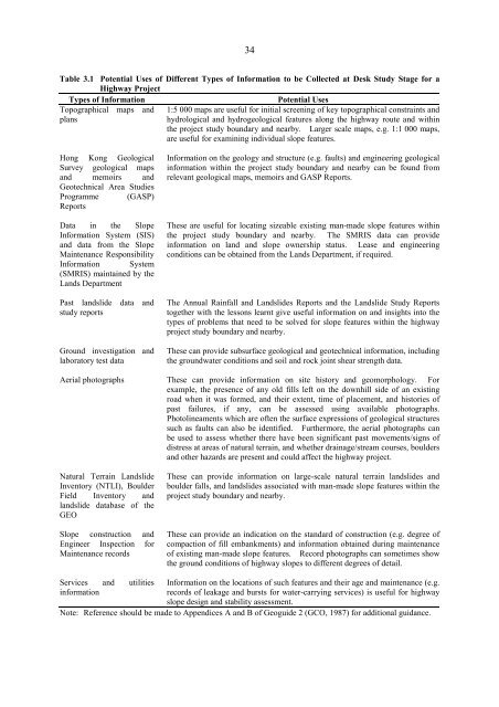
Table 3.1 Potential Uses of Different Types of Information to be Collected at Desk Study Stage for a<br />
<strong>Highway</strong> Proiect<br />
Types of Information<br />
Potential Uses<br />
Topographical maps and 1:5 000 maps are useful for initial screening of key topographical constraints and<br />
plans<br />
hydrological and hydrogeological features along the highway route and within<br />
the project study boundary and nearby. Larger scale maps, e.g. 1:1 000 maps,<br />
are useful for examining individual slope features.<br />
Hong Kong Geological Information on the geology and structure (e.g. faults) and engineering geological<br />
Survey geological maps information within the project study boundary and nearby can be found from<br />
and memoirs and relevant geological maps, memoirs and GASP Reports.<br />
Geotechnical Area Studies<br />
Programme (GASP)<br />
Reports<br />
Data in the <strong>Slope</strong> These are useful for locating sizeable existing man-made slope features within<br />
Information System (SIS) the project study boundary and nearby. The SMRIS data can provide<br />
and data from the <strong>Slope</strong> information on land and slope ownership status. Lease and engineering<br />
Maintenance Responsibility conditions can be obtained from the Lands Department, i f required.<br />
Information System<br />
(SMRIS) maintained by the<br />
Lands Department<br />
Past landslide data and<br />
study reports<br />
Ground investigation and<br />
laboratory test data<br />
The Annual Rainfall and Landslides Reports and the Landslide Study Reports<br />
together with the lessons learnt give useful information on and insights into the<br />
types of problems that need to be solved for slope features within the highway<br />
project study boundary and nearby.<br />
These can provide subsurface geological and geotechnical information, including<br />
the groundwater conditions and soil and rock joint shear strength data.<br />
Aerial photographs These can provide information on site history and geomorphology. For<br />
example, the presence of any old fills left on the downhill side of an existing<br />
road when it was formed, and their extent, time of placement, and histories of<br />
past failures, if any, can be assessed using available photographs.<br />
Photolineaments which are often the surface expressions of geological structures<br />
such as faults can also be identified. Furthermore, the aerial photographs can<br />
be used to assess whether there have been significant past movements/signs of<br />
distress at areas of natural terrain, an d whether drainage/stream courses, boulders<br />
and other hazards are present and could affect the highway project.<br />
Natural Terrain Landslide These can provide information on large-scale natural terrain landslides and<br />
Inventory (NTLI), Boulder boulder falls, and landslides associated with man-made slope features within the<br />
Field Inventory and project study boundary and nearby.<br />
landslide database of the<br />
GhO<br />
<strong>Slope</strong> construction and These can provide an indication on the standard of construction (e.g. degree of<br />
hngineer Inspection for compaction of fill embankments) and information obtained during maintenance<br />
Maintenance records of existing man-made slope features. Record photographs can sometimes show<br />
the ground conditions of highway slopes to different degrees of detail.<br />
Services and utilities Information on the locations of such features and their age and maintenance (e.g.<br />
information<br />
records of leakage and bursts for water-carrying services) is useful for highway<br />
slope design and stability assessment.<br />
Note: Reference should be made to Appendices A and B of Geoguide 2 (GCO, 1987) for additional guidance.