Highway Slope Manual
Highway Slope Manual
Highway Slope Manual

Create successful ePaper yourself
Turn your PDF publications into a flip-book with our unique Google optimized e-Paper software.
38<br />
movement monitoring and control data at carefully selected locations. In some cases, it may<br />
be worthwhile to sink drillholes and install instrumentation such as piezometers and<br />
inclinometers to provide subsurface hydrogeological and deformation information to aid<br />
interpretation. Where necessary, suitable investigations and tests should be carried out to<br />
determine the mass shear strength of the deformed ground for the purpose of slope stability<br />
assessment and design. General guidance on slope instability recognition, surface<br />
observation, geological mapping, etc., is given in Chapters 8 and 9 of TRB Special Report<br />
247 (Transportation Research Board, 1996).<br />
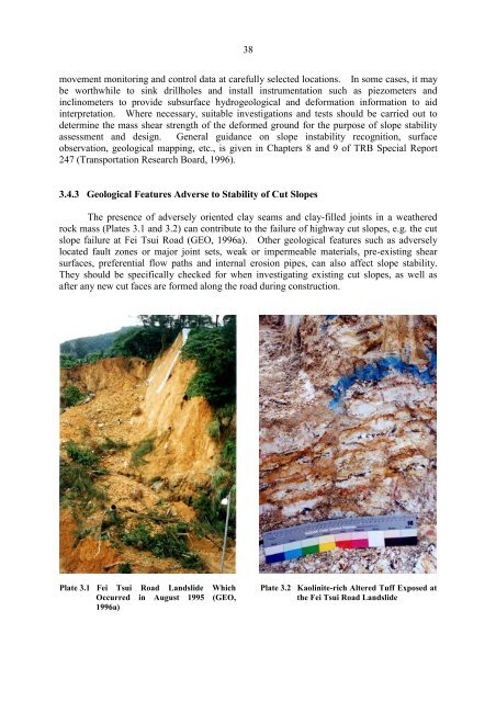
3...3 Geological Features Adverse to Stability of Cut <strong>Slope</strong>s<br />
The presence of adversely oriented clay seams and clay-filled joints in a weathered<br />
rock mass (Plates 3.1 and 3.2) can contribute to the failure of highway cut slopes, e.g. the cut<br />
slope failure at Fei Tsui Road (GEO, 1996a). Other geological features such as adversely<br />
located fault zones or major joint sets, weak or impermeable materials, pre-existing shear<br />
surfaces, preferential flow paths and internal erosion pipes, can also affect slope stability.<br />
They should be specifically checked for when investigating existing cut slopes, as well as<br />
after any new cut faces are formed along the road during construction.<br />
Plate 3.1 Fei Tsui Road Landslide Which Plate 3.2 Kaolinite-rich Altered Tuff Exposed at<br />
Occurred in August 1995 (GEO, the Fei Tsui Road Landslide<br />
1996a)