SOP for Flood Forecasting & Early Warning - UNESCO Islamabad
SOP for Flood Forecasting & Early Warning - UNESCO Islamabad
SOP for Flood Forecasting & Early Warning - UNESCO Islamabad

Create successful ePaper yourself
Turn your PDF publications into a flip-book with our unique Google optimized e-Paper software.
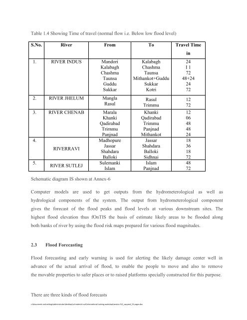
Table 1.4 Showing Time of travel (normal flow i.e. Below low flood level)<br />
S.No. River From To Travel Time<br />
1. RIVER INDUS Mandori<br />
Kalabagh<br />
Chashma<br />
Taunsa<br />
Guddu<br />
Sukkar<br />
2. RIVER JHELUM Mangla<br />
Rasul<br />
3. RIVER CHENAB Marala<br />
Khanki<br />
Qadirabad<br />
Trirnmu<br />
Panjnad<br />
4.<br />
Madhopure<br />
RIVERRAVI<br />
Jassar<br />
Shahdara<br />
Balloki<br />
5.<br />
Sulemanki<br />
RIVER SUTLEJ<br />
Islam<br />
Schematic diagram IS shown at Annex-6<br />
Kalabagh<br />
Chashma<br />
Taunsa<br />
Mithankot+Guddu<br />
Sukkar<br />
Kotri<br />
Rasul<br />
Trimmu<br />
Khanki<br />
Qadirabad<br />
Trimmu<br />
Panjnad<br />
Mithankot<br />
Jassar<br />
Shahdara<br />
Balloki<br />
Sidhnai<br />
Islam<br />
Panjnad<br />
in<br />
24<br />
I 1<br />
72<br />
48+24<br />
24<br />
72<br />
12<br />
72<br />
12<br />
06<br />
48<br />
48<br />
24<br />
18<br />
36<br />
18<br />
72<br />
48<br />
72<br />
Computer models are used to get outputs from the hydrometerological as well as<br />
hydrological components of the system. The output from hydrometerological component<br />
gives the <strong>for</strong>ecast of the flood peaks and flood levels at various downstream sites. The<br />
highest flood elevation thus fOnTIS the basis of estimate likely areas to be flooded along<br />
both banks of river by using the flood risk maps prepared <strong>for</strong> various flood magnitudes.<br />
2.3 <strong>Flood</strong> <strong>Forecasting</strong><br />
<strong>Flood</strong> <strong>for</strong>ecasting and early warning is used <strong>for</strong> alerting the likely damage center well in<br />
advance of the actual arrival of flood, to enable the people to move and also to remove<br />
the movable properties to safer places or to raised plat<strong>for</strong>ms specially constructed <strong>for</strong> this purpose.<br />
There are three kinds of flood <strong>for</strong>ecasts<br />
c:\documents and settings\administrator\desktop\cd material nust\international training workshop\session 5\2_sop pmd_51 pages.doc