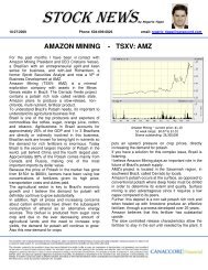
NI 43-101 Preliminary Economic Assessment - Verde Potash
NI 43-101 Preliminary Economic Assessment - Verde Potash
NI 43-101 Preliminary Economic Assessment - Verde Potash

Create successful ePaper yourself
Turn your PDF publications into a flip-book with our unique Google optimized e-Paper software.
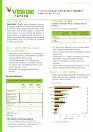
<strong>Verde</strong> <strong>Potash</strong> Plc 3-1<br />
Cerrado <strong>Verde</strong> Project<br />
<strong>NI</strong> <strong>43</strong>-<strong>101</strong> <strong>Preliminary</strong> <strong>Economic</strong> <strong>Assessment</strong><br />
3<br />
Accessibility, Climate, Local Resources,<br />
Infrastructure and Physiography (Item 5)<br />
3.1 Topography, Elevation and Vegetation<br />
The peneplane developed by the <strong>Verde</strong>te unit, i.e., the ground over which the Areado Group was<br />
deposited, undulates between the altitudes of 1,000m and 850m. Higher values are found in the<br />
southern part of the Serra da Saudade range. In the middle portion of the ridge, the peneplane is<br />
placed between 880m and 920m. Therefore, all the surface exposures of the <strong>Verde</strong>te unit were<br />
the result of the Tertiary erosion cycles that stripped off the Mesozoic rocks (Mata da Corda and<br />
Areado groups).<br />
The local vegetation consists of relicts of the primitive savanna ("cerrado") still preserved<br />
between soya and coffee plantations and industrially planted forests of eucalyptus and pine trees.<br />
The farms are mainly confined to the fertile soil of the Mata da Corda Group that forms plateaux<br />
around 1,000m.<br />
3.2 Climate and Length of Operating Season<br />
The climate of the region is classified, according to IBGE (2002) as half-humid warm tropical,<br />
with annual average temperatures of 22°C Annual rainfall in the area averages between 1,300mm<br />
and 1,800mm, 84% of which falls during the rainy season between October and March, with the<br />
highest rainfall between December and January. Operations can be year round.<br />
3.3 Physiography<br />
The region is inserted in the hydrographic basin of Indaiá River, a tributary river in the left<br />
margin of São Francisco River. According to SECTES – Secretaria do Estado de Ciência e<br />
Tecnologia de Minas Gerais – (1938), Indaiá River basin is part of the geomorphological unit<br />
São Francisco Plateau where the planning surfaces, the edges of the hills and the crests point dip<br />
to NE, with high structural control (COSTA-FILHO et al, 2007).<br />
The main drainages are the rivers Indaiá, Abaeté, Borrachudo and their tributary. The<br />
morphology of those rivers is the meandering channels and the drainage style is dendritic, mainly<br />
when installed over the pelites. In the north of the area is the Três Marias dam, main mouth of<br />
the region rivers. The water depth of the dam oscillates between the altitudes of 560 and 575m<br />
(LIMA, 2005).<br />
The main topographic feature is the Serra da Saudade ridge. The landscape can be separated into<br />
three domains that may be correlated to the South American Surfaces (King, 1956):<br />
<br />
<br />
Upper Surface: Older stage of the planning that expose the Areado Group Sandstones and<br />
Mata da Corda Group;<br />
Intermediate Surface: Refer to the second stage of the planning after de dissection of the<br />
Upper Surface, triggered by the resumption of the erosive process. The average altitude<br />
is of 750 to 850m. They are irregular surfaces stretched in N-S strike, developed over the<br />
Serra da Saudade Formation represented by psamitic lithotypes. Matches to the South<br />
American Surface I, mio-pliocene; and<br />
SRK Consulting (U.S.), Inc. September 16, 2011<br />
Cerrado <strong>Verde</strong>_<strong>NI</strong> <strong>43</strong>-<strong>101</strong> PEA_3<strong>43</strong>500.020_007_KG