SCIENCE REVIEW 1987 - Bedford Institute of Oceanography
SCIENCE REVIEW 1987 - Bedford Institute of Oceanography
SCIENCE REVIEW 1987 - Bedford Institute of Oceanography

Create successful ePaper yourself
Turn your PDF publications into a flip-book with our unique Google optimized e-Paper software.
Research<br />
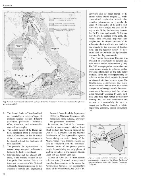
Fig. 1 Sedimentary basins <strong>of</strong> eastern Canada Separate Mesozoic - Cenozoic basins in the <strong>of</strong>fshore<br />
are not identified<br />
10<br />
The Grand Banks <strong>of</strong> Newfoundland<br />
are bounded by a variety <strong>of</strong> types <strong>of</strong><br />
margins formed through different<br />
geological processes - normally<br />
rifted, transform, and substantially<br />
stretched, as examples.<br />
The eastern margin <strong>of</strong> the Banks has<br />
been separated from a substantial<br />
source <strong>of</strong> sediment, so that the nature<br />
<strong>of</strong> the ocean-continent transition can<br />
be studied without the hindrance <strong>of</strong><br />
thick sediments.<br />
The potential for hydrocarbons in<br />
several deep marginal sedimentary<br />
basins on the Banks is significant.<br />
Newfoundland and the adjacent <strong>of</strong>fshore,<br />
is the primary location <strong>of</strong> the<br />
Lithoprobe East studies. This is an<br />
important component <strong>of</strong> the National<br />
Lithoprobe Program sponsored by the<br />
National Scientific and Engineering<br />
Research Council and the Department<br />
<strong>of</strong> Energy, Mines and Resources, with<br />
participants from industry, university<br />
and government laboratories.<br />
In addition, the Gulf <strong>of</strong> St. Lawrence<br />
provides a water-covered window from<br />
which to study the Paleozoic basins <strong>of</strong> the<br />
Gulf <strong>of</strong> St. Lawrence and the tectonic<br />
development <strong>of</strong> the Appalachian system<br />
formed during an earlier closing <strong>of</strong> the<br />
Atlantic Ocean. These Paleozoic basins can<br />
then be compared with the Mesozoic-<br />
Cenozoic basins <strong>of</strong> the present passive<br />
margin formed during the early phases <strong>of</strong><br />
seafloor spreading in the present Atlantic<br />
Ocean 100-200 million years ago.<br />
A total <strong>of</strong> 4200 kms <strong>of</strong> deep seismic<br />
reflection data (20 second two-way travel<br />
time) has been obtained so far across the<br />
Appalachian terrains, the sedimentary<br />
basins <strong>of</strong> the Grand Banks, the Gulf <strong>of</strong> St.<br />
Lawrence, and the ocean margin <strong>of</strong> the<br />
eastern Grand Banks (Figure 2). While<br />
conventional exploration seismic data<br />
provides information on typically the<br />
upper 10-12 kilometres <strong>of</strong> the earth’s crust,<br />
these data have imaged the crust all the<br />
way to the Moho, the boundary between<br />
the Earth’s crust and mantle, 30 km and<br />
more below the surface <strong>of</strong> the earth. The<br />
results have provided important new<br />
insights into the deeper structure <strong>of</strong> the<br />
sedimentary basins which in turn has led to<br />
new models for the processes <strong>of</strong> development<br />
and the tectonic history <strong>of</strong> these<br />
basins and the potential for hydrocarbon<br />
resources that they may contain.<br />
The Frontier Geoscience Program also<br />
provided an opportunity to develop and<br />
build ocean bottom seismometers (OBS).<br />
The OBS are deployed on the seafloor and<br />
record seismic events for refraction studies,<br />
providing information on the bulk nature<br />
<strong>of</strong> crustal layers and so complementing the<br />
reflection studies which map the depth and<br />
variations <strong>of</strong> interfaces between layers. The<br />
development, construction and maintenance<br />
<strong>of</strong> these OBS has been an excellent<br />
example <strong>of</strong> technology transfer between a<br />
government laboratory and the private<br />
sector. Originally designed by AGC staff,<br />
these units have been further developed by<br />
industry and are now maintained and<br />
operated very successfully for users in<br />
Canada and the United States, by a Halifax<br />
engineering company, Seastar Instruments<br />
Ltd.<br />
Fig. 2 Deep seismic reflection lines and<br />
aeromagnetic coverage <strong>of</strong> the Grand Banks and<br />
margins collected under the Frontier Geoscience<br />
Program.