SCIENCE REVIEW 1987 - Bedford Institute of Oceanography
SCIENCE REVIEW 1987 - Bedford Institute of Oceanography
SCIENCE REVIEW 1987 - Bedford Institute of Oceanography

Create successful ePaper yourself
Turn your PDF publications into a flip-book with our unique Google optimized e-Paper software.
Research<br />
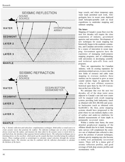
Fig. 5. Seismic reflection and refraction: complementary techniques. Both utilize a sound source to<br />
create acoustic waves that penetrate the seafloor. The reflection technique uses an array <strong>of</strong> listening<br />
devices towed near the surface, and measures the times taken by the acoustic waves to travel down to,<br />
and back from, the interfaces that separate buried sediment layers. The refraction technique uses a<br />
listening device on the sea floor, which picks up the sounds that have travelled along the sediment<br />
layers. These readings permit a seismologist to calculate sound velocities through the various<br />
sedimentary layers. The velocities can then be combined with the reflection observations to calculate<br />
the thickness <strong>of</strong> the layers.<br />
40<br />
large vessels, and where temporary open<br />
water leads permitted such work, AGC<br />
geologists have in recent years deployed<br />
small helicopter-portable craft on local<br />
expeditions to undertake mapping and<br />
sediment sampling.<br />
The future<br />
Mapping <strong>of</strong> Canada’s ocean floor over the<br />
next few decades will require the close<br />
cooperation <strong>of</strong> industry, government<br />
agencies and universities. Development <strong>of</strong><br />
new techniques for ocean mapping has<br />
historically begun in the academic community,<br />
and Canadian universities continue to<br />
be a source <strong>of</strong> innovation in ocean mapping.<br />
Government agencies have the<br />
experience <strong>of</strong> managing multi-purpose<br />
mapping programs, and <strong>of</strong> collaborating<br />
with universities in developing scientific<br />
and technical spin-<strong>of</strong>fs from such<br />
programs.<br />
There are opportunities for Canadian<br />
industry, with its existing reputation for<br />
petroleum-related surveys, to move into the<br />
new fields <strong>of</strong> resource and cable route<br />
mapping in overseas markets; these<br />
markets can be expected to grow as more<br />
coastal nations begin to appreciate the<br />
value <strong>of</strong> the new <strong>of</strong>fshore resources<br />
bestowed upon them by the UN Convention<br />
on the Law <strong>of</strong> the Sea.<br />
We anticipate that over the next two<br />
decades, all <strong>of</strong> the deep water areas<br />
adjacent to Canada’s east and west coasts<br />
will be mapped with swath mapping<br />
systems providing both bathymetry (such<br />
as obtained with SEA BEAM) and acoustic<br />
backscatter (such as obtained with<br />
SeaMARC). By then, polar mapping<br />
systems should have progressed to the<br />
point where we can routinely deploy a mix<br />
<strong>of</strong> surface and under-ice platforms for<br />
detailed measurements <strong>of</strong> water depth in<br />
permanently ice-covered waters.<br />
Within a similar time frame, the more<br />
detailed geophysical mapping <strong>of</strong> the<br />
<strong>of</strong>fshore should also be in hand. Aeromagnetic<br />
surveys will complement the extensive<br />
sets <strong>of</strong> shipboard data collected to date;<br />
given the promise <strong>of</strong> present techniques,<br />
airborne gravity mapping may also become<br />
a reality over permanently ice-covered<br />
waters. There will be a dense grid <strong>of</strong><br />
seismic reflection pr<strong>of</strong>iles, and good<br />
coverage <strong>of</strong> both deep seismic pr<strong>of</strong>iles and<br />
reconnaisance wells.