SCIENCE REVIEW 1987 - Bedford Institute of Oceanography
SCIENCE REVIEW 1987 - Bedford Institute of Oceanography
SCIENCE REVIEW 1987 - Bedford Institute of Oceanography

You also want an ePaper? Increase the reach of your titles
YUMPU automatically turns print PDFs into web optimized ePapers that Google loves.
Research<br />
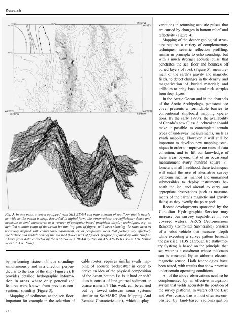
Fig. 3. In one pass, a vessel equipped with SEA BEAM can map a swath <strong>of</strong> sea floor that is nearly<br />
as wide as the ocean is deep. Recorded in digital form, the observations are sufficiently dense and<br />
accurate to lend themselves to a variety <strong>of</strong> computer-based graphical display techniques, e.g. as<br />
detailed contour maps <strong>of</strong> the ocean bottom (top part <strong>of</strong> figure, with inset showing the same area as<br />
previously mapped with conventional equipment), or as perspective views that portray very effectively<br />
the texture and undulations <strong>of</strong> the sea bed (lower part <strong>of</strong> figure). (Figure prepared by John Hughes<br />
Clarke from data collected by the NECOR SEA BEAM system on ATLANTIS II Cruise 116, Senior<br />
Scientist A.N. Shor)<br />
by performing sixteen oblique soundings<br />
simultaneously and in a direction perpendicular<br />
to the axis <strong>of</strong> the ship (Figure 2). It<br />
provides detailed hydrographic information<br />
in areas where only generalized<br />
features were known from previous conventional<br />
sounding (Figure 3).<br />
Mapping <strong>of</strong> sediments at the sea floor,<br />
important for example in the selection <strong>of</strong><br />
38<br />
cable routes, requires similar swath mapping<br />
<strong>of</strong> acoustic backscatter in order to<br />
derive an idea <strong>of</strong> the physical composition<br />
<strong>of</strong> the ocean bottom i.e. is it hard or s<strong>of</strong>t?<br />
does it consist <strong>of</strong> line-grained sediment or<br />
coarse material? This work can be carried<br />
out by towed sidescan sonar systems<br />
similar to SeaMARC (Sea Mapping And<br />
Remote Characterization), which displays<br />
variations in returning acoustic pulses that<br />
are caused by changes in bottom relief and<br />
reflectivity (Figure 4).<br />
Mapping <strong>of</strong> the deeper geological structure<br />
requires a variety <strong>of</strong> complementary<br />
techniques: seismic reflection pr<strong>of</strong>iling,<br />
similar in principle to echo sounding, but<br />
with a much stronger acoustic pulse that<br />
penetrates the sea floor and bounces <strong>of</strong>f<br />
buried layers <strong>of</strong> rock (Figure 5); measurement<br />
<strong>of</strong> the earth’s gravity and magnetic<br />
fields, to detect changes in the density and<br />
magnetization <strong>of</strong> buried material; and<br />
drillholes to bring back actual rock samples<br />
from deep layers.<br />
In the Arctic Ocean and in the channels<br />
<strong>of</strong> the Arctic Archipelago, persistent ice<br />
cover presents a formidable barrier to<br />
conventional shipboard mapping operations.<br />
By the early 1990’s, the availability<br />
<strong>of</strong> Canada’s new Class 8 icebreaker should<br />
make it possible to contemplate certain<br />
types <strong>of</strong> underway measurements, such as<br />
swath mapping. However it will still be<br />
important to develop new mapping techniques<br />
in order to improve our rates <strong>of</strong> data<br />
collection, and to lift our knowledge <strong>of</strong><br />
these areas beyond that <strong>of</strong> an occasional<br />
measurement every hundred square kilometers;<br />
in all likelihood, these techniques<br />
will entail the use <strong>of</strong> alternative survey<br />
platforms such as manned and unmanned<br />
submersibles to deploy instruments beneath<br />
the ice, and aircraft to carry out<br />
appropriate observations (such as measurements<br />
<strong>of</strong> the earth’s magnetic and gravity<br />
fields) as they overfly the polar pack.<br />
Recent developments sponsored by the<br />
Canadian Hydrographic Service may<br />
increase our survey capabilities in ice<br />
covered waters: ARCS (Autonomous<br />
Remotely Controlled Submersible) consists<br />
<strong>of</strong> a robot vehicle that measures depth<br />
while executing a survey pattern beneath<br />
the pack ice; TIBS (Through Ice Bathymetry<br />
System) is based on the principle that<br />
sea water is a conductor whose thickness<br />
can be measured by an airborne electromagnetic<br />
sensor. Both technologies have<br />
been tested, with results that show promise<br />
under certain operating conditions.<br />
All <strong>of</strong> the above observations need to be<br />
complemented by an effective navigation<br />
system that yields accurately the position <strong>of</strong><br />
the survey platform. In waters <strong>of</strong>f the East<br />
and West coasts, this is most <strong>of</strong>ten accomplished<br />
by land-based radionavigation