SCIENCE REVIEW 1987 - Bedford Institute of Oceanography
SCIENCE REVIEW 1987 - Bedford Institute of Oceanography
SCIENCE REVIEW 1987 - Bedford Institute of Oceanography

Create successful ePaper yourself
Turn your PDF publications into a flip-book with our unique Google optimized e-Paper software.
Research<br />
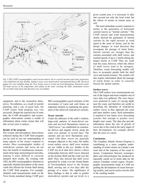
Fig. 5 The CASP oceanographers used current meters (A) to record currents and water properties<br />
every half hour for four months. Surface waves were measured by instrumented buoys (B). Sea level<br />
gauges (C) were installed along the Nova Scotia coast to record sea level fluctuations. Research vessels<br />
(D) made surveys <strong>of</strong> the temperature and salinity <strong>of</strong> the water overlying the shelf: Anemometer towers<br />
(E) recorded wind speed and direction every ten minutes.<br />
equipment, and to the researchers themselves.<br />
Nevertheless, as a result <strong>of</strong> careful<br />
planning, and a run <strong>of</strong> good luck, the<br />
CASP winter field program was very<br />
successful. Despite the expected loss <strong>of</strong> some<br />
data, the CASP atmospheric and oceanographic<br />
observations contain a wealth <strong>of</strong><br />
information about winter storms that will<br />
take several years to analyse.<br />
Results <strong>of</strong> the program.<br />
The oceanic and atmospheric observations<br />
collected during the CASP field program<br />
can be used to test our understanding <strong>of</strong><br />
many aspects <strong>of</strong> the ocean’s response to<br />
storms. Most oceanographic studies <strong>of</strong><br />
wind-driven currents and waves do not<br />
have the benefit <strong>of</strong> simultaneous measurements<br />
from large meteorological networks,<br />
making it more difficult to correctly<br />
interpret their results. By working with<br />
AES, the BIO oceanographers obtained an<br />
especially detailed description <strong>of</strong> the storm<br />
winds that affected the Scotian Shelf during<br />
the CASP field program. For example,<br />
detailed wind measurements made on the<br />
Nova Scotia mainland during CASP gave<br />
28<br />
BIO oceanographers good estimates <strong>of</strong> the<br />
movements <strong>of</strong> warm and cold fronts, an<br />
important element in explaining the generation<br />
<strong>of</strong> the observed wind-driven currents.<br />
Ocean currents<br />
Under the influence <strong>of</strong> the earth’s rotation,<br />
large-scale patterns <strong>of</strong> storm-driven currents<br />
and sea level fluctuations, known as<br />
“shelf waves,” are established on continental<br />
shelves and migrate slowly along the<br />
coast over periods <strong>of</strong> several days. The<br />
currents and sea level fluctuations associated<br />
with these waves are generally<br />
strongest adjacent to the coast, but unlike<br />
ocean surface waves, shelf wave motions<br />
are not visible to the eye. Studies <strong>of</strong> the<br />
CASP sea level data have shown a direct<br />
relationship between shelf waves detected<br />
on the Scotian Shelf and the wind over the<br />
shelf. They also showed that shelf waves<br />
generated by winds over the Grand Banks<br />
<strong>of</strong> Newfoundland travel to the Scotian<br />
Shelf, arriving one or two days after the<br />
passage <strong>of</strong> a storm. The significance <strong>of</strong><br />
these findings is that in order to predict<br />
storm-driven currents and sea levels in a<br />
given coastal area, it is necessary to take<br />
into account not only the local wind, but<br />
the effects <strong>of</strong> storms in remote areas as<br />
well.<br />
The most immediate oceanic response to<br />
storms is the generation <strong>of</strong> horizontal<br />
currents known as “inertial currents.” The<br />
CASP current and wind measurements<br />
clearly showed the generation <strong>of</strong> inertial<br />
currents by the rapid increase in wind<br />
speed at the onset <strong>of</strong> storms, and by the<br />
abrupt changes in wind direction that<br />
accompany the passage <strong>of</strong> storm fronts.<br />
Inertial currents are stronger than the<br />
currents associated with shelf waves, and<br />
reached speeds <strong>of</strong> up to 1 km/hr during the<br />
largest storms in CASP They are weak<br />
near the coast, however, where the effects<br />
<strong>of</strong> shelf waves tend to be strongest.<br />
Therefore, ocean forecasting models will<br />
have to accurately predict both the shelf<br />
wave and inertial motions. The models will<br />
also require information about the passage<br />
<strong>of</strong> storm fronts in order to correctly<br />
forecast the inertial currents.<br />
Surface waves<br />
The CASP surface wave measurements are<br />
one <strong>of</strong> the largest and most complete sets <strong>of</strong><br />
wave data ever gathered. The wave buoys<br />
were anchored in water <strong>of</strong> varying depth<br />
near the coast, and therefore are useful in<br />
describing the alteration <strong>of</strong> wind-driven<br />
surface waves as they approach the coast<br />
and enter shallow water. Such information<br />
is required to test future wave forecasting<br />
systems that attempt to predict wave<br />
heights near coasts. The data also provide<br />
information about the rate <strong>of</strong> growth <strong>of</strong><br />
waves due to the wind in the early stages <strong>of</strong><br />
their development, for example shortly<br />
after the onset <strong>of</strong> a storm.<br />
Conclusions.<br />
The Canadian Atlantic Storms Program is<br />
contributing to a more complete understanding<br />
<strong>of</strong> winter storms on Canada’s east<br />
coast and <strong>of</strong> the response <strong>of</strong> the ocean to<br />
storms. Cooperation between oceanographers<br />
and meteorologists has produced an<br />
especially useful set <strong>of</strong> storm data for the<br />
eastern Canadian coastal region. Oceanographic<br />
measurements made in CASP are<br />
guiding the development <strong>of</strong> ocean forecasting<br />
models, and can be used to test the skill<br />
<strong>of</strong> the resulting models.