SCIENCE REVIEW 1987 - Bedford Institute of Oceanography
SCIENCE REVIEW 1987 - Bedford Institute of Oceanography
SCIENCE REVIEW 1987 - Bedford Institute of Oceanography

You also want an ePaper? Increase the reach of your titles
YUMPU automatically turns print PDFs into web optimized ePapers that Google loves.
Research<br />
earth as rain, freezing rain, hail, or snow<br />
depending on the temperature <strong>of</strong> the air<br />
through which it falls.<br />
The Norwegian model <strong>of</strong> extra-tropical<br />
cyclonic storms, formulated more than half<br />
a century ago, is still used by meteorologists<br />
to describe the large-scale features <strong>of</strong><br />
storms. The weather maps carried by<br />
North American newspapers and television<br />
show them as low pressure systems,<br />
typically 1000 km in size, with their warm<br />
fronts, cold fronts, and precipitation zones,<br />
much as originally described by the<br />
Norwegian meteorologists.<br />
More recent research has shown that<br />
small-scale features also exist within<br />
storms. These features were not described<br />
by earlier investigators who relied on<br />
widely-spaced weather observers on the<br />
ground. Modern research tools, such as<br />
weather radar and sensitive instruments<br />
carried into the atmosphere by balloons<br />
and aircraft, have revealed that within<br />
storms there are cells and bands <strong>of</strong> intense<br />
precipitation only 10-50 km wide. The<br />
wind patterns, when viewed in detail, are<br />
much more complex than implied by the<br />
large-scale Norwegian model. Narrow<br />
zones <strong>of</strong> high winds are found along the<br />
warm and cold fronts. These small-scale<br />
storm features may have devastating effects<br />
in terms <strong>of</strong> property damage and loss <strong>of</strong><br />
life, but cannot be predicted using presentday<br />
weather observing and forecasting<br />
methods.<br />
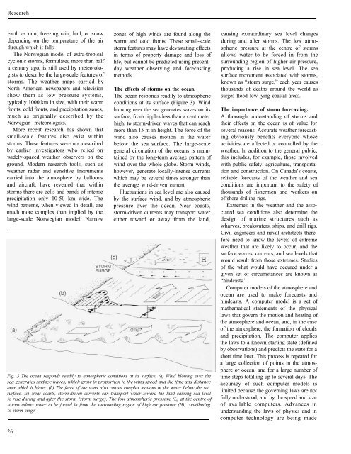
The effects <strong>of</strong> storms on the ocean.<br />
The ocean responds readily to atmospheric<br />
conditions at its surface (Figure 3). Wind<br />
blowing over the sea generates waves on its<br />
surface, from ripples less than a centimeter<br />
high, to storm-driven waves that can reach<br />
more than 15 m in height. The force <strong>of</strong> the<br />
wind also causes motion in the water<br />
below the sea surface. The large-scale<br />
general circulation <strong>of</strong> the oceans is maintained<br />
by the long-term average pattern <strong>of</strong><br />
wind over the whole globe. Storm winds,<br />
however, generate locally-intense currents<br />
which may be several times stronger than<br />
the average wind-driven current.<br />
Fluctuations in sea level are also caused<br />
by the surface wind, and by atmospheric<br />
pressure over the ocean. Near coasts,<br />
storm-driven currents may transport water<br />
either toward or away from the land,<br />
Fig. 3 The ocean responds readily to atmospheric conditions at its surface. (a) Wind blowing over the<br />
sea generates surface waves, which grow in proportion to the wind speed and the time and distance<br />
over which it blows. (b) The force <strong>of</strong> the wind also causes complex motions in the water below the sea<br />
surface. (c) Near coasts, storm-driven currents can transport water toward the land causing sea level<br />
to rise during and after the storm (storm surge). The low atmospheric pressure (L) at the centre <strong>of</strong><br />
storms allows water to be forced in from the surrounding region <strong>of</strong> high air pressure (H), contributing<br />
to storm surge.<br />
26<br />
causing extraordinary sea level changes<br />
during and after storms. The low atmospheric<br />
pressure at the centre <strong>of</strong> storms<br />
allows water to be forced in from the<br />
surrounding region <strong>of</strong> higher air pressure,<br />
producing a rise in sea level. The sea<br />
surface movement associated with storms,<br />
known as “storm surge,” each year causes<br />
thousands <strong>of</strong> deaths around the world as<br />
surges flood low-lying coastal areas.<br />
The importance <strong>of</strong> storm forecasting.<br />
A thorough understanding <strong>of</strong> storms and<br />
their effects on the ocean is <strong>of</strong> value for<br />
several reasons. Accurate weather forecasting<br />
obviously benefits everyone whose<br />
activities are affected or controlled by the<br />
weather. In addition to the general public,<br />
this includes, for example, those involved<br />
with public safety, agriculture, transportation<br />
and construction. On Canada’s coasts,<br />
reliable forecasts <strong>of</strong> the weather and sea<br />
conditions are important to the safety <strong>of</strong><br />
thousands <strong>of</strong> fishermen and workers on<br />
<strong>of</strong>fshore drilling rigs.<br />
Extremes in the weather and the associated<br />
sea conditions also determine the<br />
design <strong>of</strong> marine structures such as<br />
wharves, breakwaters, ships, and drill rigs.<br />
Civil engineers and naval architects therefore<br />
need to know the levels <strong>of</strong> extreme<br />
weather that are likely to occur, and the<br />
surface waves, currents, and sea levels that<br />
would result from those extremes. Studies<br />
<strong>of</strong> the what would have occured under a<br />
given set <strong>of</strong> circumstances are known as<br />
“hindcasts.”<br />
Computer models <strong>of</strong> the atmosphere and<br />
ocean are used to make forecasts and<br />
hindcasts. A computer model is a set <strong>of</strong><br />
mathematical statements <strong>of</strong> the physical<br />
laws that govern the motion and heating <strong>of</strong><br />
the atmosphere and ocean, and, in the case<br />
<strong>of</strong> the atmosphere, the formation <strong>of</strong> clouds<br />
and precipitation. The computer applies<br />
the laws to a known starting state (defined<br />
by observations) and predicts the state for a<br />
short time later. This process is repeated for<br />
a large collection <strong>of</strong> points in the atmosphere<br />
or ocean, and for a large number <strong>of</strong><br />
time steps totalling up to several days. The<br />
accuracy <strong>of</strong> such computer models is<br />
limited because the governing laws are not<br />
fully understood, and by the speed and size<br />
<strong>of</strong> available computers. Advances in<br />
understanding the laws <strong>of</strong> physics and in<br />
computer technology are being made