SCIENCE REVIEW 1987 - Bedford Institute of Oceanography
SCIENCE REVIEW 1987 - Bedford Institute of Oceanography
SCIENCE REVIEW 1987 - Bedford Institute of Oceanography

Create successful ePaper yourself
Turn your PDF publications into a flip-book with our unique Google optimized e-Paper software.
The Canadian Atlantic Storms Program (CASP)<br />
C. Anderson<br />
C. Anderson<br />
The origin <strong>of</strong> winter storms.<br />
THE winter weather most Canadians<br />
experience living halfway between the<br />
equator and the North Pole is due largely<br />
to the interaction between two air masses<br />
- the cold polar air mass, and the warmer<br />
subtropical air mass. The irregular boundary<br />
between these two air masses, called<br />
the polar front, circles the earth between 30<br />
and 60 degrees north latitude (Figure 1).<br />
Our stormy weather is caused by atmos-<br />
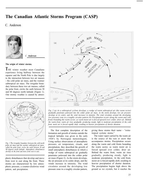
Fig. 1 The irregular boundary between the cold north<br />
polar air mass and the warmer subtropical air mass,<br />
called the polar front, circles the earth between 30 and<br />
60 degrees north latitude. Atmospheric disturbances<br />
develop on the front and move from west to east.<br />
pheric disturbances that develop and move<br />
from west to east along the front. These<br />
storms are characterized by low atmospheric<br />
pressure, a counter-clockwise wind<br />
pattern, and precipitation.<br />
Fig. 2 (a) As a subtropical cyclone develops, a wedge <strong>of</strong> warm subtropical air (the warm sector)<br />
gradual& penetrates poleward into the colder polar air mass. As the storm develops, low air pressure<br />
develops at its centre, and the wind increases in intensity. The wind circulates around the developing<br />
low pressure zone in a roughly circular pattern (b) Precipitation occurs along the warm and cold<br />
fronts bounding the warm sector, as warm moist air is forced upward over colder, drier air. Behind<br />
the warm front, warm air rises gradual&, producing steady, light to moderate precipitation At the cold<br />
front, moist air is forced rapidly al<strong>of</strong>t, resulting in heavier precipitation <strong>of</strong> shorter duration.<br />
The first complete description <strong>of</strong> the<br />
formation and growth <strong>of</strong> storms outside the<br />
tropical latitudes was given in the early<br />
1920’s by Norwegian meteorologists.<br />
Using surface observations <strong>of</strong> atmospheric<br />
pressure, air temperature, clouds, and<br />
precipitation, they described the growth <strong>of</strong><br />
small atmospheric disturbances in which a<br />
wedge <strong>of</strong> warm subtropical air gradually<br />
penetrates poleward into the colder polar<br />
air mass (Figure 2). As the storm develops,<br />
the air pressure at its centre drops, and the<br />
winds increase in intensity. The wind<br />
circulates around the developing low<br />
pressure zone in a roughly circular pattern,<br />
giving these storms their name - “extratropical<br />
cyclonic storms.”<br />
The water vapor carried by the warm air<br />
is the source <strong>of</strong> the rain or snow that<br />
accompanies storms. Precipitation occurs<br />
along the warm and cold fronts bounding<br />
the warm sector, as warm moist air is<br />
forced upward over colder, drier air.<br />
Behind the warm front, warm air rises<br />
gradually, producing steady, light to<br />
moderate precipitation. At the cold front,<br />
moist air is forced rapidly al<strong>of</strong>t, resulting in<br />
heavier precipitation <strong>of</strong> shorter duration.<br />
The precipitation begins high above the<br />
ground as ice crystals, but it reaches the<br />
25