SCIENCE REVIEW 1987 - Bedford Institute of Oceanography
SCIENCE REVIEW 1987 - Bedford Institute of Oceanography
SCIENCE REVIEW 1987 - Bedford Institute of Oceanography

You also want an ePaper? Increase the reach of your titles
YUMPU automatically turns print PDFs into web optimized ePapers that Google loves.
Research<br />
The EC will enable shipping to move<br />
under conditions where at present it would<br />
remain tied up and to navigate more safely<br />
and to tighter schedules at all times. This<br />
will reduce shipping costs, and, once<br />
proved, will also reduce insurance premiums.<br />
It will minimize the risk <strong>of</strong> grounding<br />
leading to loss <strong>of</strong> life, property damage and<br />
pollution with its high clean-up costs.<br />
The heart <strong>of</strong> the EC is the digital data or<br />
EC Data Base (ECDB) it uses to draw the<br />
various chart features on the display. To<br />
date EC manufacturers and mariners have<br />
been digitizing nautical charts themselves<br />
for their systems. In the (near?) future,<br />
when GPS becomes available and the<br />
technology improves the demand for<br />
digital chart data will increase dramatically.<br />
Since Hydrographic Offices are<br />
responsible for producing the nautical<br />
charts the responsibility will naturally fall<br />
on them to supply this data. Most <strong>of</strong> the<br />
Hydrographic Offices around the world<br />
presently have very little <strong>of</strong> their nautical<br />
chart information in digital form. Experience<br />
with existing data bases tells us that<br />
long before the full ECDB is available the<br />
problem <strong>of</strong> keeping it up-to-date will far<br />
outweigh the task <strong>of</strong> getting old data into it.<br />
The problem is exacerbated by the fact<br />
that, unlike land based data bases where<br />
the users can have easy access via the<br />
phone lines, etc. the users <strong>of</strong> the ECDB will<br />
be at sea most <strong>of</strong> the time. Special<br />
internationally agreed upon data exchange<br />
techniques and data formats therefore may<br />
be needed for both the original data and<br />
updates.<br />
A number <strong>of</strong> activities that are presently<br />
taking place within Canada and internationally<br />
are described in the following<br />
pages.<br />
Precise Integrated Navigation System<br />
(PINS)<br />
With one notable exception most EC<br />
activity in Canada has been in the Canadian<br />
Hydrographic Service (CHS), Department<br />
<strong>of</strong> Fisheries and Oceans. The<br />
exception is the Precise Integrated Navigation<br />
System, an EC developed by Offshore<br />
Systems Ltd., North Vancouver, B.C. They<br />
first developed their EC to help ships<br />
navigate in the ice-covered Beaufort Sea<br />
during oil exploration. They began marketing<br />
it in 1986 and presently have systems<br />
operating on both coasts <strong>of</strong> North America<br />
46<br />
as well as on Coast Guard icebreakers in<br />
the St. Lawrence River. They are now<br />
working on a new EC system, the Shipboard<br />
Integrated Navigation and Display<br />
System (SINADS), which will integrate<br />
radar with all the existing features <strong>of</strong> PINS.<br />
The CHS Electronic Chart Testbed<br />
The CHS EC program was started in the<br />
late seventies and was coordinated by Mike<br />
Eaton, Head, B.I.O. Navigation Group<br />
until just recently when he retired. The<br />
CHS EC program can be broken down<br />
into the following interrelated projects:<br />
- the Electronic Chart Testbed and EC<br />
Specifications<br />
- Electronic Chart Data Base (ECDB)<br />
Studies<br />
- Display Design and Advanced Features<br />
- Data Exchange Techniques and<br />
Formats<br />
The EC Testbed development was started<br />
in 1984:<br />
“1. To develop specifications for the<br />
ECDB to be produced by the CHS<br />
and<br />
2. To investigate the effect <strong>of</strong> the EC on<br />
safe navigation.”<br />
(Eaton, <strong>1987</strong>)<br />
One main design requirement was that the<br />
Testbed should be flexible. Flexibility, that<br />
is, the ability to change the display,<br />
demonstrate different optional approaches<br />
to EC problems, etc. were, and still are,<br />
more important for the Testbed than speed,<br />
user friendliness and other characteristics <strong>of</strong><br />
operational systems. In order to achieve the<br />
necessary flexibility it was also decided<br />
to use the Universal Systems Ltd.<br />
(Fredericton, N.B.) Computer Aided<br />
Resource Information System (CARIS) as<br />
the basis for the Testbed because it had the<br />
geographic information management infrastructure<br />
necessary to manage the very<br />
complex EC features and also because<br />
CARIS was already widely used throughout<br />
the CHS. Digital charts had already<br />
been created using CARIS.<br />
At present the EC Testbed consists <strong>of</strong> a<br />
modified CARIS system and Radar and<br />
Positioning subsystems. The CARIS system<br />
consists <strong>of</strong> a Digital Equipment Corp.<br />
microvax II computer with 5 megabytes <strong>of</strong><br />
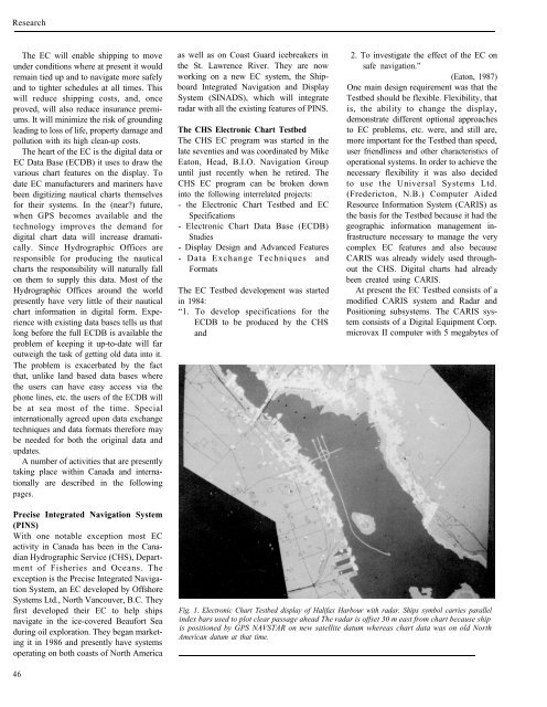
Fig. 1. Electronic Chart Testbed display <strong>of</strong> Halifax Harbour with radar. Ships symbol carries parallel<br />
index bars used to plot clear passage ahead The radar is <strong>of</strong>fset 30 m east from chart because ship<br />
is positioned by GPS NAVSTAR on new satellite datum whereas chart data was on old North<br />
American datum at that time.