SCIENCE REVIEW 1987 - Bedford Institute of Oceanography
SCIENCE REVIEW 1987 - Bedford Institute of Oceanography
SCIENCE REVIEW 1987 - Bedford Institute of Oceanography

You also want an ePaper? Increase the reach of your titles
YUMPU automatically turns print PDFs into web optimized ePapers that Google loves.
Research<br />
River. On this survey it is estimated that<br />
over 100 million depth measurements were<br />
made, <strong>of</strong> which 1.5 million were logged for<br />
subsequent data processing!<br />
Before the first project was completed,<br />
the system’s capabilities were clearly<br />
demonstrated. Several large boulders in the<br />
dredged channel that had been missed by<br />
conventional survey techniques were<br />
detected by the sweep system. It has been<br />
successfully deployed on many projects in<br />
Nova Scotia and New Brunswick. In a<br />
demonstration <strong>of</strong> its arctic capabilities, the<br />
system was used to carry out a survey on<br />
the southern coast <strong>of</strong> Ellesmere Island near<br />
the community <strong>of</strong> Grise Fiord during the<br />
summer <strong>of</strong> 1984. In addition, the system<br />
was loaned to Public Works Canada along<br />
with training and support from the CHS<br />
for a number <strong>of</strong> their projects. They, in<br />
turn, have recently acquired a system for<br />
their own use.<br />
The FCG Smith<br />
The success <strong>of</strong> the “transportable”<br />
system provided a catalyst for a second and<br />
larger dedicated sweep vessel. The goal was<br />
to acquire the most modem, efficient and<br />
capable sweep system in the world. A<br />
contract for the construction <strong>of</strong> the FCG<br />
Smith was awarded to Georgetown Ship-<br />
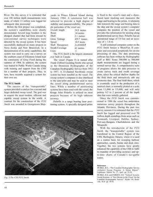
Fig. 5 The CSS FCG Smith.<br />
44<br />
yards in Prince Edward Island during<br />
January 1984. A catamaran hull was<br />
selected to provide a high degree <strong>of</strong><br />
stability and manoeuverability. The principle<br />
particulars <strong>of</strong> the vessel are:<br />
Overall length 34.8 metres<br />
Beam 14 metres<br />
Draft 2.1 metres<br />
Gross Tonnage 429.7 tonnes<br />
Speed 10.5 knots<br />
Shaft Horsepower 2x400HP<br />
Swath Coverage 42 metres<br />
Crew 11<br />
The FCG Smith is the largest catamaran<br />
ever built in Canada.<br />
The vessel (Figure 5) is named after<br />
Frank Clifford Goulding Smith who served<br />
as the Dominion Hydrographer <strong>of</strong> the<br />
Canadian Hydrographic Service from 1952<br />
to 1957. A 33-channel Navitronic sweep<br />
system has been installed on the vessel. The<br />
sweep system’s computer is also interfaced<br />
to the auto-pilot and may be used to steer<br />
the vessel along predetermined survey<br />
lines. While a number <strong>of</strong> positioning<br />
systems have been used with the vessel, the<br />
Krupp Atlas Polarfix is utilized on most<br />
projects because <strong>of</strong> its high inherent<br />
accuracy.<br />
Polarfix is a range bearing laser positioning<br />
system. A specially designed prism<br />
is fixed to the vessel’s mast and a shorebased<br />
laser tracking unit measures the<br />
range and bearing to the prism. A telemetry<br />
link transmits the range and bearing data to<br />
the ship and the sweep system’s computer<br />
computes the position <strong>of</strong> the vessel and<br />
provides this information for steering along<br />
predetermined survey lines. Polarfix has an<br />
operational range <strong>of</strong> 5.0 km and an accuracy<br />
<strong>of</strong> ± 1.0 m.<br />
A self-contained computer center on the<br />
FCG Smith houses a MicroVax II computer<br />
and associated peripherals for on-site<br />
processing <strong>of</strong> data. The data processing<br />
s<strong>of</strong>tware has been written by Hydrographic<br />
staff at BIO. Some 300,000 to 500,000<br />
depth measurements are logged during a<br />
normal survey day. A comprehensive suite<br />
<strong>of</strong> programs allows the data processor to<br />
create survey track and swath coverage<br />
plots, select the critical shallow depths for<br />
the field sheet and interactively edit any<br />
erroneous data. The final field sheet, which<br />
is eventually used in the production <strong>of</strong> a<br />
nautical chart, is normally plotted at a scale<br />
from l/1,000 to l/5,000, and will only<br />
portray 0.5 to 2 percent <strong>of</strong> all the depth<br />
data that were initially gathered.<br />
Since the FCG Smith was commissioned<br />
in 1986 the vessel has undertaken<br />
numerous survey projects throughout the<br />
Atlantic Provinces. During the past two<br />
survey seasons it is estimated that the FCG<br />
Smith has logged and processed over 50<br />
million depth soundings from areas such as<br />
Yarmouth, Liverpool, Halifax, Sydney,<br />
Port-aux-Basques, Charlottetown and the<br />
Miramichi.<br />
With the introduction <strong>of</strong> the FCG<br />
Smith, the “transportable” system was<br />
transferred to the Central Region <strong>of</strong> the<br />
CHS, Burlington, Ontario, where it is used<br />
on a routine basis for sweeping harbour<br />
approaches, canals, basins and dock sites.<br />
Together, the two systems have greatly<br />
enhanced the capability <strong>of</strong> the CHS to fulfil<br />
its mandate <strong>of</strong> providing accuracy and upto-date<br />
charts <strong>of</strong> Canada’s navigable<br />
waters.<br />
References<br />
BURKE, R.G., “The Canadian Hydrographic Service<br />
(Atlantic) Sweep Program. A Status Report”.<br />
Lighthouse, Edition No. 27, April. pp. 25-30.<br />
BURKE, R.G. and FORBES, S.R. “Vertical Acoustic<br />
Sweep Systems: A ‘New Broom in the Closet’ for the<br />
Canadian Hydrographic Service”. Hydro ‘84, Rockville,<br />
M.D. pp. 50-58.