Finding Potential Sites for Small-Scale Hydro Power in Uganda: a ...
Finding Potential Sites for Small-Scale Hydro Power in Uganda: a ...
Finding Potential Sites for Small-Scale Hydro Power in Uganda: a ...

Create successful ePaper yourself
Turn your PDF publications into a flip-book with our unique Google optimized e-Paper software.
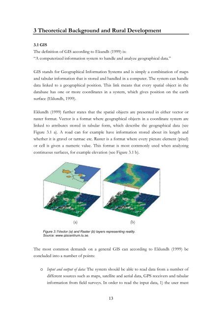
3 Theoretical Background and Rural Development3.1 GISThe def<strong>in</strong>ition of GIS accord<strong>in</strong>g to Ekundh (1999) is:“A computerized <strong>in</strong><strong>for</strong>mation system to handle and analyze geographical data.”GIS stands <strong>for</strong> Geographical In<strong>for</strong>mation Systems and is simply a comb<strong>in</strong>ation of mapsand tabular <strong>in</strong><strong>for</strong>mation that is stored and handled <strong>in</strong> a computer. The system can handledata l<strong>in</strong>ked to a geographical position. This l<strong>in</strong>k means that every spatial object <strong>in</strong> thedatabase has one or more coord<strong>in</strong>ates <strong>in</strong> a system, which gives position on the earthsurface (Eklundh, 1999).Eklundh (1999) further states that the spatial objects are presented <strong>in</strong> either vector orraster <strong>for</strong>mat. Vector is a <strong>for</strong>mat where geographical objects <strong>in</strong> a coord<strong>in</strong>ate system arel<strong>in</strong>ked to attributes stored <strong>in</strong> tabular <strong>for</strong>m, which describe the geographical data (seeFigure 3.1 a). A road can <strong>for</strong> example have <strong>in</strong><strong>for</strong>mation stored about its length andwhether it is gravel or tarmac etc. Raster is a <strong>for</strong>mat where every picture element (pixel)or cell is given a numeric value. This <strong>for</strong>mat is most commonly used when analyz<strong>in</strong>gcont<strong>in</strong>uous surfaces, <strong>for</strong> example elevation (see Figure 3.1 b).(a)(b)Figure 3.1Vector (a) and Raster (b) layers represent<strong>in</strong>g reality.Source: www. giscentrum.lu.se.The most common demands on a general GIS can accord<strong>in</strong>g to Eklundh (1999) beconcluded <strong>in</strong>to a number of po<strong>in</strong>ts:o Input and output of data: The system should be able to read data from a number ofdifferent sources such as maps, satellite and aerial data, GPS receivers and tabular<strong>in</strong><strong>for</strong>mation from field surveys. In order to read the <strong>in</strong>put data, 1) the user must13