gpa_east_africa_case.. - GRID Africa GeoPortal - UNEP
gpa_east_africa_case.. - GRID Africa GeoPortal - UNEP
gpa_east_africa_case.. - GRID Africa GeoPortal - UNEP

Create successful ePaper yourself
Turn your PDF publications into a flip-book with our unique Google optimized e-Paper software.
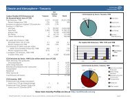
Annex IIIDar-es-Salaam Regional and City ProfileLocation. Dar-es-Salaam (DSM) lies in the <strong>east</strong>ern part of Tanzania mainland, locatedbetween latitudes 6 0 27’ and 7 0 15’ South of equator and between 39 0 and 39 0 33’ <strong>east</strong> of theGreen Witch Meridian line. It lies between 6.34’ and 7.10’ South on the West Indian Oceancoastline, stretching about 100 km between the Mpiji River to the north and beyond theMzinga River in the south, enclosing a land of 1,350km 2 . The region is divided into threeMunicipal Districts, namely Ilala, Kinondoni and Temeke that are subdivided into 72 wards.Population. DSM is the commercial capital and largest urban center in Tanzania. It has anestimated population of 3.5 million people, Ilala 800,000, Kinondoni 1,200,000 and Temeke1,500,000. Since 1988 the average growth rate has been about 8% per annum. The totalnumber of households is about 547,000 with an average size of 6.4 persons. 70% of thepopulation live in 40 unplanned settlements.Population distribution by District, 1999DistrictPopulationIlala 800,000Kinondoni 1,200,000Temeke 1,500,000Total 3,500,000Source: Dar es Salaam City CouncilClimate. DSM region has tropical equatorial climate, a mean annual temperature of 26 0 C andan average humidity of 96% in the morning and 67% in the afternoon. The annual rainfallaverages over 1000mm.Morphological characteristics. The region is characterised by four distinct landforms:(a) Shoreline & Beach: The shoreland immediately abutting the sea, comprising sand dunesand tidal swamps.(b) Coastal Plain: A limestone coastal plain to the west of shoreland extending to the Puguhills, overlain with clay bound Pleistocene with fairly uniform relief lying between 15 and35m above sea level and slopes of less than 3%. Whilst extending 10kms to the west ofthe city, the plain narrows to 2kms at Kawe in the north before widening to 8kms at theMpiji river, and varies between 8-5kms in width to the southwest where the relief is moreirregular gradually merges into the more elevated head waters of Mzinga river. Lakes andponds are scattered throughout this landform where rich clay soils and zero gradientimpede natural drainage.(c) Inland Alluvial Plains: Rivers originating from the Pugu hills to the <strong>east</strong> dissect the coastalplain in a series of steep sided U-shaped valleys, culminating in creeks and mangroveswamps before entering the Indian Ocean. Dar es Salaam harbor penetrating almost10kms inland along the Kizinga and Mzinga creeks forming the principal topographicalfeature of the region. These valley soils are generally poorly drained silt clays enrichedwith organic matters.(d) Upland Plateau: The deeply dissected Pugu hills, which bound the region to the westaverage 100 to 200m above mean sea level rising some 330m at some point, arecharacterised by steep weathered slopes and well drained of unconsolidated gravely clayboundsoils.Water Resources. The region contains watersheds of 4 major rivers. Mpiji River forms thenorthern boundary of DSM, Msimbazi River flows to the north of the city centre and Kizingaand Mzinga Rivers flow into the harbour area of the city. There are also smaller water coursessuch as Nyakasangwe, Tegeta, Mbezi, Sinza, Tabata, Minerva. Apart from a small pumpingstation at Mtoni on the Kizinga River, all regulated water comes from Ruvu River outside thecity boundary. Due to the distance involved, there is high leakage and limited free flow. Theregion will always rely on external surface sources as groundwater is not only polluted fromeffluents but contains high degree of salinity. Whilst the primary function of these riversystems is for drainage with only a small pumping station in Kizinga River, some streams areFinal Draft Report – Cost Benefit Case StudiesGPA Strategic Action Plan on Sewage, October, 200078
![Please Click to download [English] - GRID Africa GeoPortal - UNEP](https://img.yumpu.com/30633391/1/184x260/please-click-to-download-english-grid-africa-geoportal-unep.jpg?quality=85)