gpa_east_africa_case.. - GRID Africa GeoPortal - UNEP
gpa_east_africa_case.. - GRID Africa GeoPortal - UNEP
gpa_east_africa_case.. - GRID Africa GeoPortal - UNEP

You also want an ePaper? Increase the reach of your titles
YUMPU automatically turns print PDFs into web optimized ePapers that Google loves.
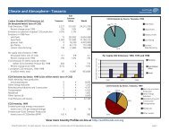
Annex IVSeychelles (Beau Valon Area) ProfileSituated in the Western Indian Ocean between 4 and 11 degrees south of the equator, theRepublic of Seychelles comprises a group of 115 islands with a land area of 455 km 2 , spreadover an Exclusive Economic Zone (EEZ) of over 1.3 million square kilometres.Forty-one of the islands in the group are granitic and mountainous, considered to befragments of the ancient Gondwanaland. They are all found within a radius of 50 km from themain granitic island of Mahé, which with a land area of 154 square kilometres, amounts toone third of the total land area of Seychelles.The islands are of rugged formation and great scenic beauty, some seemingly rising straightout of the sea to great heights. Because of their mountainous nature there is little flat land.Mahé is the most important island. It lies between 4 and 5 degrees South and 55 and 56degrees East. Mahé is about 27km long and up to 11 km wide. A range of mountain runsdown the whole length, most of which are over 300m, rising to the peak of Morne Seychelloisat 905m.Description of study area. The study area is Greater Beau Vallon; it is situated in the NorthWest of Mahé and covers a total area of 1,100 hectares, elevation varies from 0 to 880metres. The area has an enclosed body of water with two embryonic fringing reefs. The sandybeach extends app. 1.8km bounds to the north with piles of granite rocks and to the west withgranitic reefs. Apart from this beach the coastline of the bay consists of some small creeksseparated from one another by the in-situ rock.Human Development. The site is highly developed with about 20% of the land urbanised.This includes human settlements and hotels. There are relatively dense settlements along thecoast, as well as three of the island’s largest hotels and several guesthouses and restaurants.It is a prime tourism and leisure activity area. It is also an important fish-landing site, withsome limited fishing activity.Urban development includes three categories: a heavily built-up centre around the three mainhotels in the Pascal Village and Bel Ombre districts (about 35 inhabitants/ha), a less densearea at Mare Anglaise (about 13 inhabitants/ha) and the sparsely populated sectors (about 7inhabitants/ha) to the north at a higher elevation. Many dwellings are built on sloping land andare difficult to access. The grounds are very rocky with large granite boulders. In many <strong>case</strong>s,the ravine will be the only outlet for wastewater.Hydrology. Overlooking the Beau Vallon/Bel Ombre area are heights of up to 880 m inaltitude at the Morne Seychellois mountain group. There are two main rivers emptying into thebay, the Sullivan river and the Mare Anglaise river. These form the main estuaries in the area.There are also five smaller rivers in the study area. Water catchment basins are very small.There is no in-depth seepage and virtually no groundwater reservoirs. In spite of the retardingeffect of the very dense vegetation, the runoff water concentration times are very short (from15 to 60 minutes). As a consequence, rainfall immediately causes flooding in certain areas.The land area of the catchment is between 1000 and 1100 hectares, while elevation variesfrom 0 to 880 metres. Its mean annual rainfall varies from 2000mm to 3200mm at an altitudeof 800 metres. The area is covered by relatively dense vegetation, which protects the groundfrom excessive erosion from tropical rainfall. Most of the streams that empty into the bay arelittered with granite rocks which creates individual pools of stagnant water and irregularities inthe breadth of the river. (Payet, 1996).Climate. The climate of the Beau Vallon area is similar to the other areas of Mahé. The BelOmbre area receives around 3,000mm rain per annum as compared to the mean for Mahé,which is 2,524mm. There are relatively strong South<strong>east</strong> trade winds in May and October,which have an effect on the coastal water movements. Heavy rainfall is typical during theNorthwest monsoons.Final Draft Report – Cost Benefit Case StudiesGPA Strategic Action Plan on Sewage, October, 200088
![Please Click to download [English] - GRID Africa GeoPortal - UNEP](https://img.yumpu.com/30633391/1/184x260/please-click-to-download-english-grid-africa-geoportal-unep.jpg?quality=85)