concept design san antonio river improvements project
concept design san antonio river improvements project
concept design san antonio river improvements project

You also want an ePaper? Increase the reach of your titles
YUMPU automatically turns print PDFs into web optimized ePapers that Google loves.
INTEGRATION WITH OTHER PROJECTS<br />
Unified Development Code<br />
In May 2001, the City of San Antonio completed a<br />
revised Unified Development Code (UDC). In<br />
August 2001, San Antonio City Council is expected to<br />
consider an additional component to the UDC that<br />
outlines a River Overlay District for the entire <strong>river</strong>,<br />
called the River Zone Districts. The districts will<br />
preserve the character of the San Antonio River and<br />
ensure public access to the <strong>river</strong> from the roadways<br />
and commercial/residential facilities. The San<br />
Antonio River Improvements Master Plan is intended<br />
to work hand-in-hand with the development<br />
opportunities outlined by the UDC. The major<br />
requirements outlined in the UDC include:<br />
1. Standards for Landscape Design at the Street Level<br />
2. Standards for Landscape Design at the River Level<br />
3. Building Design Standards<br />
4. Awnings and Canopies<br />
5. Mechanical Equipment and Service Utilities<br />
6. Portable Carts<br />
7. Boats, Barges and Water Taxis<br />
8. Parking<br />
9. Signs<br />
Additional linkages from the <strong>river</strong> and into the<br />
surrounding city are very important for the long-term<br />
viability of the <strong>river</strong>. In the north, the most important<br />
connections are east to Broadway Street and west to<br />
St. Mary’s Street. These connections must be<br />
considered when addressing the bridge crossings and<br />
access from the street to the <strong>river</strong>. The Historical<br />
Mission (Southern) Reach linkages include those to the<br />
Missions, existing parks, and adjacent neighborhoods.<br />
Mission Trails<br />
The City of San Antonio has been working on the<br />
Mission Trails Project since 1992. The first phase of<br />
<strong>improvements</strong> has been implemented and the second<br />
phase is anticipated to begin in late 2000. This Design<br />
Guidelines manual has been carefully coordinated with<br />
that plan to integrate pathway systems and minimize<br />
duplicated work.<br />
It is also a goal of the River Improvements Project to<br />
link the <strong>river</strong> with important destination points. This<br />
includes the Missions and other historic destinations in<br />
the south and the San Antonio Museum of Art and<br />
other cultural institutions in the north. The <strong>design</strong><br />
teams should consider these opportunities when<br />
preparing the final <strong>design</strong> solutions.<br />
The City, in coordination with neighborhood groups<br />
and other citizen groups, has also developed a plan for<br />
an on-street bicycle pathway through downtown to<br />
connect the two Reaches. A Hike and Bike Pathway<br />
Diagram is included as an Appendix. It describes the<br />
entire pathway system for the <strong>project</strong>, which will be<br />
approximately 15 miles long in its entirety.<br />
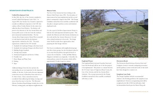
Existing Mission Trails Bridge<br />
Eagleland Project<br />
The Eagleland Reach, between Guenther Street and<br />
Lone Star Boulevard, will be one of the first <strong>project</strong>s<br />
to be implemented. This <strong>project</strong> is a venture between<br />
the US Army Corps of Engineers, Bexar County, the<br />
City of San Antonio, and the San Antonio River<br />
Authority. The <strong>concept</strong>s presented in this Design<br />
Guidelines manual have been carefully coordinated<br />
with them, as well.<br />
Typical south channel<br />
Downtown Reach<br />
The Downtown Reach between Houston Street and<br />
Lexington Avenue is currently undergoing restoration<br />
and the pathway systems north and south of that reach<br />
have been <strong>design</strong>ed to connect to it.<br />
Symphony Lane Study<br />
The Design Guidelines include a recommended<br />
solution to the flooding problem at the Symphony Lane<br />
neighborhood. However, an engineering study will be<br />
completed in the fall of 2001 that will make a final<br />
recommendation based upon the Master Plan goals.<br />
SAN ANTONIO RIVER DESIGN GUIDELINES 19