concept design san antonio river improvements project
concept design san antonio river improvements project
concept design san antonio river improvements project

You also want an ePaper? Increase the reach of your titles
YUMPU automatically turns print PDFs into web optimized ePapers that Google loves.
HISTORICAL MISSION (SOUTHERN) REACH<br />
FLOOD CONTROL - HYDRAULIC MODEL<br />
A key goal of the plan is the preserving and<br />
enhancing, if possible, flood control aspects. To<br />
ensure this, the master plan team modeled existing<br />
conditions as well as the proposed channel<br />
modifications using the U.S. Army Corps of<br />
Engineers, Hydrologic Engineering Center, River<br />
Analysis System (HEC-RAS) computer program.<br />
This model computes water surface elevations based<br />
on channel conditions (e.g., size, shape, vegetation,<br />
etc.) and a storm discharge.<br />
The overall modeling objective has been to develop<br />
reasonably accurate models for existing and proposed<br />
conditions and to use the modeling to help guide<br />
efforts to develop a <strong>river</strong> restoration scenario (i.e.,<br />
proposed conditions) that will not increase flooding<br />
conditions along the study reach of the <strong>river</strong>. In<br />
many respects, the modeling was aimed at balancing<br />
the amount of additional cross sectional area required<br />
to offset the added vegetation (e.g., trees, underbrush<br />
and natives grasses) proposed for the <strong>river</strong> corridor.<br />
The modeling performed at this <strong>concept</strong> <strong>design</strong> level<br />
is primarily intended to be a comparative evaluation<br />
between existing and proposed conditions and it<br />
should be recognized that additional and more<br />
detailed modeling will be required when the <strong>project</strong><br />
moves to preliminary and final <strong>design</strong>.<br />
Development of the existing and proposed HEC-<br />
RAS models was generally based on the utilization of<br />
a preliminary existing condition model of the San<br />
Antonio River obtained from the Corps of Engineers.<br />
The Corps constructed the model from recent aerial<br />
topographic data, preliminary flow estimates, local<br />
32 SAN ANTONIO RIVER DESIGN GUIDELINES<br />
bridge data and other data/information. Manning<br />
roughness factors for existing conditions were<br />
obtained from a previous 1997 study performed by<br />
Freese and Nichols, Inc. entitled “San Antonio River<br />
Flood Control Channel Modifications – Preliminary<br />
Engineering Analysis Report”. Consistent with this<br />
previous work, Manning “n” factors of 0.03 for the<br />
main <strong>river</strong> channel and 0.07 for the overbank areas<br />
were adopted for existing conditions. According to<br />
the U. S. Geological Survey, Manning’s roughness<br />
coefficient, n, commonly is used to represent flow<br />
resistance for hydraulic computations of water flow in<br />
open channels. Expansion and contraction<br />
coefficients were reviewed and changed where needed<br />
to reflect standard modeling guidelines. Certain nonessential<br />
cross sections in the Corps preliminary<br />
existing condition model were removed from this<br />
study’s planning level analysis to simplify the<br />
comparative analysis without sacrificing significant<br />
accuracy. The basic model setup also includes 15<br />
bridges and two inline weirs, one of which is the<br />
Espada Dam.<br />
The proposed condition model was created from the<br />
existing condition model but includes the following<br />
differences:<br />
1. Cross sections in numerous locations along the<br />
<strong>river</strong> were enlarged to generally incorporate fluvial<br />
geomorphological <strong>concept</strong>s. Generally, the <strong>river</strong>’s<br />
existing meanders were increased or lengthened by<br />
widening the <strong>river</strong>’s cross section on the channel’s<br />
outer side.<br />
2. Removal of Espada Dam as an approach to<br />
decreasing/eliminating the flooding at the<br />
Symphony Lane neighborhood.<br />
EXISTING<br />
3. Incorporation of “big water” areas that are being<br />
planned as below (existing) grade features. These<br />
water areas will be developed by excavating below<br />
the existing channel bottom so small dams above<br />
the existing grade will not be required to create the<br />
water bodies. The small rock dams proposed will<br />
be consistent with the existing bottom profile.<br />
4. As mentioned above, cross sections were added to<br />
the original model to enable results to reflect the<br />
varying vegetation conditions. Adjustments to the<br />
vegetation limits (i.e. vegetation moved away from<br />
the channel center) were made in several instances<br />
to prevent vegetation near the channel from<br />
increasing water levels and water energy grade<br />
elevations adversely.<br />
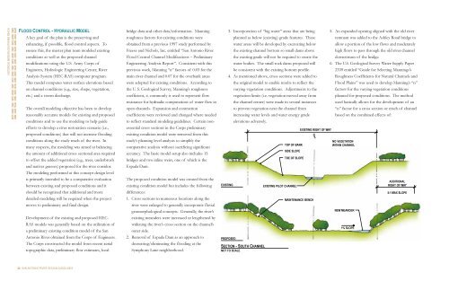
PROPOSED<br />
SECTION - SOUTH CHANNEL<br />
NOT TO SCALE<br />
EXISTING RIGHT OF WAY<br />
C<br />
L<br />
NO VEGETATION<br />
TOP OF BANK<br />
WITHIN CHANNEL<br />
SIDE SLOPE<br />
TOE OF SLOPE<br />
EXISTING PILOT CHANNEL<br />
MAINTENANCE BENCH<br />
5. An expanded opening aligned with the old <strong>river</strong><br />
remnant was added to the Ashley Road bridge to<br />
allow a portion of the low flows and moderately<br />
high flows to pass through the old <strong>river</strong> channel<br />
downstream of the bridge.<br />
6. The U.S. Geological Survey Water-Supply Paper<br />
2339 entitled “Guide for Selecting Mannings’s<br />
Roughness Coefficients for Natural Channels and<br />
Flood Plains” was used to develop Manning’s “n”<br />
factors for the varying vegetation conditions<br />
planned for proposed conditions. The method<br />
used basically allows for the development of an<br />
“n” factor for a cross section or reach of channel<br />
based on the combined effects of:<br />
NEW MEANDER<br />
1% SLOPE<br />
ADDITIONAL<br />
RIGHT OF WAY<br />
5:1 MAX SLOPE