concept design san antonio river improvements project
concept design san antonio river improvements project
concept design san antonio river improvements project

You also want an ePaper? Increase the reach of your titles
YUMPU automatically turns print PDFs into web optimized ePapers that Google loves.
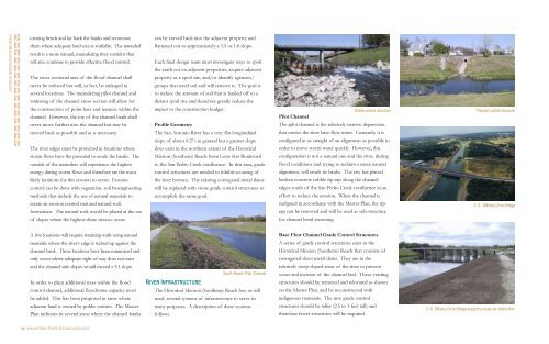
HISTORICAL MISSION (SOUTHERN) REACH<br />
existing bends and lay back the banks and recontour<br />
them where adequate land area is available. The intended<br />
result is a more natural, meandering <strong>river</strong> corridor that<br />
will also continue to provide effective flood control.<br />
The cross sectional area of the flood channel shall<br />
never be reduced but will, in fact, be enlarged in<br />
several locations. The meandering pilot channel and<br />
widening of the channel cross section will allow for<br />
the construction of point bars and terraces within the<br />
channel. However, the toe of the channel bank shall<br />
never move further into the channel but may be<br />
moved back as possible and as is necessary.<br />
The <strong>river</strong> edges must be protected in locations where<br />
storm flows have the potential to erode the banks. The<br />
outside of the meanders will experience the highest<br />
energy during storm flows and therefore are the most<br />
likely locations for this erosion to occur. Erosion<br />
control can be done with vegetation, soil bioengineering<br />
methods that include the use of natural materials to<br />
create an erosion control mat and natural rock<br />
formations. The natural rock would be placed at the toe<br />
of slopes where the highest shear stresses occur.<br />
A few locations will require retaining walls using natural<br />
materials where the <strong>river</strong>’s edge is tucked up against the<br />
channel bank. These locations have been minimized and<br />
only occur where adequate right-of-way does not exist<br />
and the channel side slopes would exceed a 3:1 slope.<br />
In order to plant additional trees within the flood<br />
control channel, additional floodwater capacity must<br />
be added. This has been proposed in areas where<br />
adjacent land is owned by public entities. The Master<br />
Plan indicates in several areas where the channel banks<br />
34 SAN ANTONIO RIVER DESIGN GUIDELINES<br />
can be carved back into the adjacent property and<br />
flattened out to approximately a 1:5 or 1:6 slope.<br />
Each final <strong>design</strong> team must investigate ways to spoil<br />
the earth cut on adjacent properties, acquire adjacent<br />
property as a spoil site, and/or identify agencies/<br />
groups that need soil and will remove it. The goal is<br />
to reduce the amount of soil that is hauled off to a<br />
distant spoil site and therefore greatly reduce the<br />
impact to the construction budget.<br />
Profile Geometry<br />
The San Antonio River has a very flat longitudinal<br />
slope of about 0.2% in general but a greater slope<br />
does exist in the northern extent of the Historical<br />
Mission (Southern) Reach from Lone Star Boulevard<br />
to the San Pedro Creek confluence. In this area, grade<br />
control structures are needed to inhibit scouring of<br />
the <strong>river</strong> bottom. The existing corrugated metal dams<br />
will be replaced with stone grade control structures to<br />
accomplish the same goal.<br />
RIVER INFRASTRUCTURE<br />
South Reach Pilot Channel<br />
The Historical Mission (Southern) Reach has, or will<br />
need, several systems of infrastructure to serve its<br />
many purposes. A description of these systems<br />
follows.<br />
Grade control structure<br />
Pilot Channel<br />
The pilot channel is the relatively narrow depression<br />
that carries the <strong>river</strong> base flow water. Currently, it is<br />
configured in as straight of an alignment as possible in<br />
order to move storm water quickly. However, this<br />
configuration is not a natural one and the <strong>river</strong>, during<br />
flood conditions and trying to reclaim a more natural<br />
alignment, will erode its banks. The city has placed<br />
broken concrete rubble rip-rap along the channel<br />
edges south of the San Pedro Creek confluence in an<br />
effort to reduce the erosion. When the channel is<br />
realigned in accordance with the Master Plan, the riprap<br />
can be removed and will be used as sub-structure<br />
for channel bend armoring.<br />
Base Flow Channel Grade Control Structures<br />
A series of grade control structures exist in the<br />
Historical Mission (Southern) Reach that consists of<br />
corrugated sheet metal dams. They are in the<br />
relatively steep sloped areas of the <strong>river</strong> to prevent<br />
scour and incision of the channel bed. These existing<br />
structures should be removed and relocated as shown<br />
on the Master Plan, and be reconstructed with<br />
indigenous materials. The new grade control<br />
structures should be taller (2.5 to 3 feet tall) and<br />
therefore fewer structures will be required.<br />
Tributary outfall structure<br />
S. E. Military Drive Bridge<br />
S. E. Military Drive Bridge supports create an obstruction