concept design san antonio river improvements project
concept design san antonio river improvements project
concept design san antonio river improvements project

Create successful ePaper yourself
Turn your PDF publications into a flip-book with our unique Google optimized e-Paper software.
• A base “n” factor for a straight, smooth, uniform<br />
channel in natural materials;<br />
• Surface irregularities;<br />
• Variations in cross sections;<br />
• Obstructions;<br />
• Vegetation; and<br />
• Channel meandering.<br />
Utilizing this method, composite “n” factors were<br />
developed for the following <strong>river</strong> vegetation<br />
conditions:<br />
• 505 trees/acre (~ 10 ft. o.c. out of channel in overbank)<br />
“n”=0.07<br />
• 225 trees/acre (~ 15 ft. o.c. with shrub understory)<br />
“n”=0.065<br />
• 225 trees/acre (~ 15 ft. o.c. with grass understory)<br />
“n”=0.057; and<br />
• 56 trees/acre (~ 30 ft. o.c. groups near channel bottom)<br />
“n”=0.045.<br />
7. The cross sections associated with the bridges were<br />
modified to accommodate recreational trails<br />
planned along the <strong>river</strong> (refer to the Appendix).<br />
The basic procedure was to incorporate a 20-foot<br />
wide section cut into both bridge abutments (e.g.,<br />
sides of the bridge opening) except at South Cross<br />
Avenue where the trail is only planned on the east<br />
side.<br />
Summaries of existing and proposed conditions<br />
modeling output are also included in the Appendix.<br />
The basic conclusion that can be drawn from the<br />
HEC-RAS modeling comparison is that the proposed<br />
conditions will provide improved 100-year flooding<br />
conditions compared to existing flooding conditions.<br />
When the proposed modifications are actually<br />
<strong>design</strong>ed for each reach, final <strong>design</strong> teams must rerun<br />
the model using more precise channel geometry<br />
and vegetation densities to again ensure that the<br />
<strong>design</strong> does not increase the existing 100-year water<br />
surface elevations. The HEC-RAS model and<br />
supporting information is available through SARA.<br />
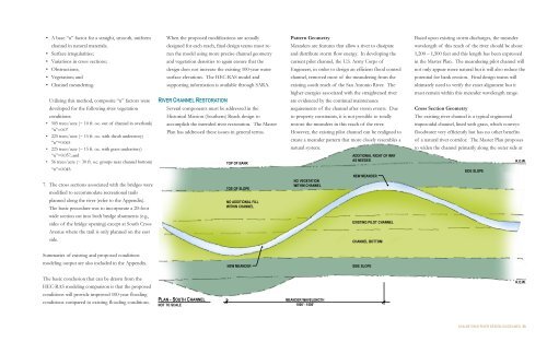
RIVER CHANNEL RESTORATION<br />
Several components must be addressed in the<br />
Historical Mission (Southern) Reach <strong>design</strong> to<br />
accomplish the intended <strong>river</strong> restoration. The Master<br />
Plan has addressed these issues in general terms.<br />
PLAN - SOUTH CHANNEL<br />
NOT TO SCALE<br />
TOP OF BANK<br />
TOE OF SLOPE<br />
NO ADDITIONAL FILL<br />
WITHIN CHANNEL<br />
NEW MEANDER<br />
Pattern Geometry<br />
Meanders are features that allow a <strong>river</strong> to dissipate<br />
and distribute storm flow energy. In developing the<br />
current pilot channel, the U.S. Army Corps of<br />
Engineers, in order to <strong>design</strong> an efficient flood control<br />
channel, removed most of the meandering from the<br />
existing south reach of the San Antonio River. The<br />
higher energies associated with the straightened <strong>river</strong><br />
are evidenced by the continual maintenance<br />
requirements of the channel after storm events. Due<br />
to property constraints, it is not possible to totally<br />
restore the meanders in this reach of the <strong>river</strong>.<br />
However, the existing pilot channel can be realigned to<br />
create a meander pattern that more closely resembles a<br />
natural system.<br />
NO VEGETATION<br />
WITHIN CHANNEL<br />
MEANDER WAVELENGTH<br />
1000’ - 1500’<br />
ADDITIONAL RIGHT OF WAY<br />
AS NEEDED<br />
NEW MEANDER<br />
EXISTING PILOT CHANNEL<br />
CHANNEL BOTTOM<br />
SIDE SLOPE<br />
Based upon existing storm discharges, the meander<br />
wavelength of this reach of the <strong>river</strong> should be about<br />
1,200 – 1,500 feet and this length has been expressed<br />
in the Master Plan. The meandering pilot channel will<br />
not only appear more natural but it will also reduce the<br />
potential for bank erosion. Final <strong>design</strong> teams will<br />
ultimately need to verify the exact alignment but it<br />
must remain within this meander wavelength range.<br />
Cross Section Geometry<br />
The existing <strong>river</strong> channel is a typical engineered<br />
trapezoidal channel, lined with grass, which conveys<br />
floodwater very efficiently but has no other benefits<br />
of a natural <strong>river</strong> corridor. The Master Plan proposes<br />
to widen the channel primarily along the outer side at<br />
SIDE SLOPE<br />
R.O.W.<br />
R.O.W.<br />
SAN ANTONIO RIVER DESIGN GUIDELINES 33