- Page 1 and 2:
© Barry Truit, TNC© Donna A. Dewh
- Page 3 and 4:
Assessment Core TeamSally YozellJen
- Page 5 and 6:
Chapter 1 - IntroductionImportant s
- Page 7 and 8:
Chapter 1 - Introductionabsorb wave
- Page 9 and 10:
Chapter 1 - Introduction1) Gulf of
- Page 11 and 12:
Chapter 1 - IntroductionSpecies and
- Page 13 and 14:
Chapter 1 - IntroductionSea Turtles
- Page 15 and 16:
Chapter 1 - Introduction(NECIA 2007
- Page 17 and 18:
Chapter 1 - IntroductionMurawski, S
- Page 19 and 20:
Coastal EcosystemsCHAPTER2Barbara V
- Page 21 and 22:
Chapter 2 - Coastal EcosystemsSelec
- Page 23 and 24:
Chapter 2 - Coastal EcosystemsTable
- Page 25 and 26:
Chapter 2 - Coastal EcosystemsFigur
- Page 27 and 28:
Chapter 2 - Coastal EcosystemsThis
- Page 29 and 30:
Chapter 2 - Coastal Ecosystemsestua
- Page 31 and 32:
Chapter 2 - Coastal Ecosystems© Ro
- Page 33 and 34:
Chapter 2 - Coastal Ecosystemsfish,
- Page 35 and 36:
Chapter 2 - Coastal Ecosystemsfrom
- Page 37 and 38:
Chapter 2 - Coastal EcosystemsFigur
- Page 39 and 40: Chapter 2 - Coastal EcosystemsFigur
- Page 41 and 42: Chapter 2 - Coastal Ecosystemsare s
- Page 43 and 44: Chapter 2 - Coastal EcosystemsTable
- Page 45 and 46: Chapter 2 - Coastal EcosystemsTable
- Page 47 and 48: Chapter 2 - Coastal EcosystemsFigur
- Page 49 and 50: Chapter 2 - Coastal EcosystemsFigur
- Page 51 and 52: Chapter 2 - Coastal EcosystemsFigur
- Page 53 and 54: Chapter 2 - Coastal EcosystemsFigur
- Page 55 and 56: Chapter 2 - Coastal EcosystemsFigur
- Page 57 and 58: Chapter 2 - Coastal EcosystemsFigur
- Page 59 and 60: Chapter 2 - Coastal EcosystemsABCDF
- Page 61 and 62: Chapter 2 - Coastal Ecosystems2007)
- Page 63 and 64: Chapter 2 - Coastal Ecosystemsactiv
- Page 65 and 66: Chapter 2 - Coastal Ecosystemsnot c
- Page 67 and 68: Chapter 2 - Coastal EcosystemsPredi
- Page 69 and 70: Chapter 2 - Coastal Ecosystemsmeasu
- Page 71 and 72: Chapter 2 - Coastal Ecosystemsenvir
- Page 73 and 74: Chapter 2 - Coastal EcosystemsBrick
- Page 75 and 76: Chapter 2 - Coastal EcosystemsEPA (
- Page 77 and 78: Chapter 2 - Coastal EcosystemsLi, X
- Page 79 and 80: Chapter 2 - Coastal EcosystemsNords
- Page 81 and 82: Chapter 2 - Coastal EcosystemsSheph
- Page 83 and 84: Chapter 2 - Coastal EcosystemsVirgi
- Page 85 and 86: Chapter 3 - Benthic HabitatsTechnic
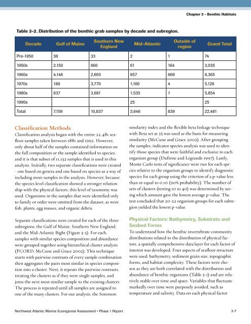
- Page 87 and 88: Chapter 3 - Benthic HabitatsTable 3
- Page 89: Chapter 3 - Benthic HabitatsFigure
- Page 93 and 94: Chapter 3 - Benthic HabitatsTable 3
- Page 95 and 96: Chapter 3 - Benthic HabitatsFigure
- Page 97 and 98: Chapter 3 - Benthic HabitatsFigure
- Page 99 and 100: Chapter 3 - Benthic HabitatsContine
- Page 101 and 102: Chapter 3 - Benthic HabitatsFigure
- Page 103 and 104: Chapter 3 - Benthic HabitatsTable 3
- Page 105 and 106: Chapter 3 - Benthic HabitatsFigure
- Page 107 and 108: Chapter 3 - Benthic HabitatsFigure
- Page 109 and 110: Chapter 3 - Benthic HabitatsFigure
- Page 111 and 112: Chapter 3 - Benthic HabitatsDescrip
- Page 113 and 114: Chapter 3 - Benthic HabitatsCnidari
- Page 115 and 116: Chapter 3 - Benthic HabitatsCone sn
- Page 117 and 118: Chapter 3 - Benthic HabitatsMollusk
- Page 119 and 120: Chapter 3 - Benthic HabitatsShallow
- Page 121 and 122: Chapter 3 - Benthic HabitatsMollusk
- Page 123 and 124: Chapter 3 - Benthic HabitatsNemerte
- Page 125 and 126: Chapter 3 - Benthic HabitatsMollusk
- Page 127 and 128: Chapter 3 - Benthic HabitatsVery Sh
- Page 129 and 130: Chapter 3 - Benthic HabitatsFlabell
- Page 131 and 132: Chapter 3 - Benthic HabitatsAnnelid
- Page 133 and 134: Chapter 3 - Benthic HabitatsArthrop
- Page 135 and 136: Chapter 3 - Benthic Habitats© SBNM
- Page 137 and 138: Chapter 3 - Benthic HabitatsLITERAT
- Page 139 and 140: Chapter 3 - Benthic HabitatsLevin,
- Page 141 and 142:
Chapter 3 - Benthic HabitatsAPPENDI
- Page 143 and 144:
Chapter 3 - Benthic HabitatsDepth (
- Page 145 and 146:
Physical OceanographyCHAPTER4Caroly
- Page 147 and 148:
Chapter 4 - Physical OceanographyHa
- Page 149 and 150:
Chapter 4 - Physical OceanographySe
- Page 151 and 152:
Chapter 4 - Physical Oceanographycl
- Page 153 and 154:
Chapter 4 - Physical OceanographyAB
- Page 155 and 156:
Chapter 4 - Physical OceanographyAB
- Page 157 and 158:
Chapter 4 - Physical OceanographyAB
- Page 159 and 160:
Chapter 4 - Physical Oceanographytr
- Page 161 and 162:
Chapter 4 - Physical OceanographyAB
- Page 163 and 164:
Chapter 4 - Physical OceanographyAB
- Page 165 and 166:
Chapter 4 - Physical OceanographyAB
- Page 167 and 168:
Chapter 4 - Physical OceanographyMc
- Page 169 and 170:
CHAPTER5Marine Fishes:Introduction
- Page 171 and 172:
Chapter 5 - Marine Fishes: Introduc
- Page 173 and 174:
Chapter 5 - Marine Fishes: Introduc
- Page 175 and 176:
Chapter 5 - Marine Fishes: Introduc
- Page 177 and 178:
Diadromous FishAlison BowdenCHAPTER
- Page 179 and 180:
Chapter 6 - Diadromous FishJames (V
- Page 181 and 182:
Chapter 6 - Diadromous FishFigure 6
- Page 183 and 184:
Chapter 6 - Diadromous FishNo trend
- Page 185 and 186:
Chapter 6 - Diadromous FishABCDFigu
- Page 187 and 188:
Chapter 6 - Diadromous FishFigure 6
- Page 189 and 190:
Chapter 6 - Diadromous FishFigure 6
- Page 191 and 192:
Chapter 6 - Diadromous FishImportan
- Page 193 and 194:
Chapter 6 - Diadromous FishFigure 6
- Page 195 and 196:
Chapter 6 - Diadromous FishRainbow
- Page 197 and 198:
Chapter 6 - Diadromous FishFigure 6
- Page 199 and 200:
Chapter 6 - Diadromous FishFigure 6
- Page 201 and 202:
Chapter 6 - Diadromous Fish© Bridg
- Page 203 and 204:
Chapter 6 - Diadromous Fishprogram
- Page 205 and 206:
Chapter 6 - Diadromous FishSturgeon
- Page 207 and 208:
Chapter 6 - Diadromous FishSea-run
- Page 209 and 210:
Chapter 6 - Diadromous FishCollette
- Page 211 and 212:
Chapter 6 - Diadromous FishThoreau,
- Page 213 and 214:
Chapter 7 - Demersal FishSelection
- Page 215 and 216:
Chapter 7 - Demersal FishAtlantic w
- Page 217 and 218:
Chapter 7 - Demersal FishABCDFigure
- Page 219 and 220:
Chapter 7 - Demersal FishABCDFigure
- Page 221 and 222:
Chapter 7 - Demersal FishABCDFigure
- Page 223 and 224:
Chapter 7 - Demersal FishABCDFigure
- Page 225 and 226:
Chapter 7 - Demersal FishABCDFigure
- Page 227 and 228:
Chapter 7 - Demersal FishABCDFigure
- Page 229 and 230:
Chapter 7 - Demersal FishABCDFigure
- Page 231 and 232:
Chapter 7 - Demersal FishABCDFigure
- Page 233 and 234:
Chapter 7 - Demersal FishABCDFigure
- Page 235 and 236:
Chapter 7 - Demersal FishABCDFigure
- Page 237 and 238:
Chapter 7 - Demersal FishABCDFigure
- Page 239 and 240:
Chapter 7 - Demersal FishABCDFigure
- Page 241 and 242:
Chapter 7 - Demersal FishABCDFigure
- Page 243 and 244:
Chapter 7 - Demersal FishABCDFigure
- Page 245 and 246:
Chapter 7 - Demersal FishABCDFigure
- Page 247 and 248:
Chapter 7 - Demersal FishABCDFigure
- Page 249 and 250:
Chapter 7 - Demersal FishABCDFigure
- Page 251 and 252:
Chapter 7 - Demersal FishABCDFigure
- Page 253 and 254:
Chapter 7 - Demersal FishABCDFigure
- Page 255 and 256:
Chapter 7 - Demersal FishABCDFigure
- Page 257 and 258:
Chapter 7 - Demersal FishABCDFigure
- Page 259 and 260:
Chapter 7 - Demersal FishABCDFigure
- Page 261 and 262:
Chapter 7 - Demersal FishABCDFigure
- Page 263 and 264:
Chapter 7 - Demersal FishABCDFigure
- Page 265 and 266:
Chapter 7 - Demersal FishABCDFigure
- Page 267 and 268:
Chapter 7 - Demersal FishABCDFigure
- Page 269 and 270:
Chapter 7 - Demersal FishABCDFigure
- Page 271 and 272:
Chapter 7 - Demersal FishABCDFigure
- Page 273 and 274:
Chapter 7 - Demersal FishABCDFigure
- Page 275 and 276:
Chapter 7 - Demersal FishABCDFigure
- Page 277 and 278:
Chapter 7 - Demersal FishABCDFigure
- Page 279 and 280:
Chapter 7 - Demersal FishABCDFigure
- Page 281 and 282:
Chapter 7 - Demersal FishHuman Inte
- Page 283 and 284:
Chapter 7 - Demersal FishInvasive s
- Page 285 and 286:
Chapter 7 - Demersal FishRed hake a
- Page 287 and 288:
Chapter 7 - Demersal Fishbe signifi
- Page 289 and 290:
Chapter 7 - Demersal FishGeorges Ba
- Page 291 and 292:
Chapter 7 - Demersal FishShelf. Spa
- Page 293 and 294:
Chapter 7 - Demersal FishAcadian Re
- Page 295 and 296:
Chapter 7 - Demersal FishThey appea
- Page 297 and 298:
Chapter 7 - Demersal FishLiterature
- Page 299 and 300:
Chapter 7 - Demersal FishLock, M.C.
- Page 301 and 302:
Chapter 7 - Demersal FishSteimle, F
- Page 303 and 304:
Chapter 8 - Small Pelagic FishSelec
- Page 305 and 306:
Chapter 8 - Small Pelagic FishABCDF
- Page 307 and 308:
Chapter 8 - Small Pelagic FishABCDF
- Page 309 and 310:
Chapter 8 - Small Pelagic FishABCDF
- Page 311 and 312:
Chapter 8 - Small Pelagic FishABCDF
- Page 313 and 314:
Chapter 8 - Small Pelagic FishABCDF
- Page 315 and 316:
Chapter 8 - Small Pelagic FishABCDF
- Page 317 and 318:
Chapter 8 - Small Pelagic Fish© Jo
- Page 319 and 320:
Chapter 8 - Small Pelagic Fishdo ha
- Page 321 and 322:
Chapter 8 - Small Pelagic Fishlater
- Page 323 and 324:
Chapter 8 - Small Pelagic FishLiter
- Page 325 and 326:
Large Pelagic FishCHAPTER9Jennifer
- Page 327 and 328:
Chapter 9 - Large Pelagic Fisha 50%
- Page 329 and 330:
Chapter 9 - Large Pelagic FishAreas
- Page 331 and 332:
Chapter 9 - Large Pelagic FishABCDF
- Page 333 and 334:
Chapter 9 - Large Pelagic FishFigur
- Page 335 and 336:
Chapter 9 - Large Pelagic FishFigur
- Page 337 and 338:
Chapter 9 - Large Pelagic FishFigur
- Page 339 and 340:
Chapter 9 - Large Pelagic FishFigur
- Page 341 and 342:
Chapter 9 - Large Pelagic FishFigur
- Page 343 and 344:
Chapter 9 - Large Pelagic FishFigur
- Page 345 and 346:
Chapter 9 - Large Pelagic FishFigur
- Page 347 and 348:
Chapter 9 - Large Pelagic Fishjuven
- Page 349 and 350:
Chapter 9 - Large Pelagic FishFigur
- Page 351 and 352:
Chapter 9 - Large Pelagic Fishhave
- Page 353 and 354:
Chapter 9 - Large Pelagic Fish© NO
- Page 355 and 356:
Chapter 9 - Large Pelagic FishBlue
- Page 357 and 358:
Chapter 9 - Large Pelagic Fishwith
- Page 359 and 360:
Chapter 9 - Large Pelagic Fish(Huet
- Page 361 and 362:
Chapter 9 - Large Pelagic FishCastr
- Page 363 and 364:
Chapter 9 - Large Pelagic FishGrubb
- Page 365 and 366:
Chapter 9 - Large Pelagic FishMerso
- Page 367 and 368:
Chapter 9 - Large Pelagic FishSprin
- Page 369 and 370:
Chapter 10 - CetaceansSelection of
- Page 371 and 372:
Chapter 10 - CetaceansFigure 10-1.
- Page 373 and 374:
Chapter 10 - CetaceansABCDFigure 10
- Page 375 and 376:
Chapter 10 - CetaceansMinke WhaleFo
- Page 377 and 378:
Chapter 10 - CetaceansABCDFigure 10
- Page 379 and 380:
Chapter 10 - Cetaceans© Claire Fac
- Page 381 and 382:
Chapter 10 - CetaceansABCDFigure 10
- Page 383 and 384:
Chapter 10 - CetaceansSperm WhaleDa
- Page 385 and 386:
Chapter 10 - CetaceansABCDFigure 10
- Page 387 and 388:
Chapter 10 - Cetaceanscetaceans, th
- Page 389 and 390:
Chapter 10 - CetaceansNew England,
- Page 391 and 392:
Chapter 10 - CetaceansHarbor Porpoi
- Page 393 and 394:
Chapter 10 - Cetaceanster the speci
- Page 395 and 396:
Chapter 10 - Cetaceanssubmerged for
- Page 397 and 398:
Chapter 10 - CetaceansBowen, W. D.
- Page 399 and 400:
Chapter 10 - CetaceansGeraci, J. R.
- Page 401 and 402:
Chapter 10 - CetaceansKenney, R. D.
- Page 403 and 404:
Chapter 10 - CetaceansMussoline, S.
- Page 405 and 406:
Chapter 10 - CetaceansPayne, P. M.,
- Page 407 and 408:
Chapter 10 - CetaceansSouthall, B.
- Page 409 and 410:
Sea TurtleAdam Whelchel and Melissa
- Page 411 and 412:
Chapter 11 Sea TurtlesIn the Northw
- Page 413 and 414:
Chapter 11 Sea Turtles1992). Calcul
- Page 415 and 416:
Chapter 11 Sea TurtlesABCDFigure 11
- Page 417 and 418:
Chapter 11 Sea Turtles(nonfisheries
- Page 419 and 420:
Chapter 11 Sea Turtles© Ryan Hager
- Page 421 and 422:
Chapter 11 Sea TurtlesLewison, R. L
- Page 423 and 424:
Chapter 12 - Coastal & Marine Birds
- Page 425 and 426:
Chapter 12 - Coastal & Marine Birds
- Page 427 and 428:
Chapter 12 - Coastal & Marine Birds
- Page 429 and 430:
Chapter 12 - Coastal & Marine Birds
- Page 431 and 432:
Chapter 12 - Coastal & Marine Birds
- Page 433 and 434:
Chapter 12 - Coastal & Marine Birds
- Page 435 and 436:
Chapter 12 - Coastal & Marine Birds
- Page 437 and 438:
Chapter 12 - Coastal & Marine Birds
- Page 439 and 440:
Chapter 12 - Coastal & Marine Birds
- Page 441 and 442:
Chapter 12 - Coastal & Marine Birds
- Page 443 and 444:
Chapter 12 - Coastal & Marine Birds
- Page 445 and 446:
Chapter 12 - Coastal & Marine Birds
- Page 447 and 448:
Humans Within NorthwestAtlantic Eco
- Page 449 and 450:
Chapter 13 - Human UsesSocio-econom
- Page 451 and 452:
Chapter 13 - Human UsesFigure 13-1.
- Page 453 and 454:
Chapter 13 - Human UsesUnfortunatel
- Page 455 and 456:
Next StepsCHAPTER14Jay Odell, Mark
- Page 457 and 458:
Chapter 14 - Next StepsDeveloping I
- Page 459 and 460:
Chapter 14 - Next StepsLiterature C