annual edition - 2011 - Indian Naval Hydrographic Department
annual edition - 2011 - Indian Naval Hydrographic Department
annual edition - 2011 - Indian Naval Hydrographic Department
Create successful ePaper yourself
Turn your PDF publications into a flip-book with our unique Google optimized e-Paper software.
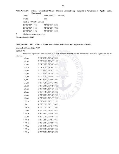
53*085(P)/(02/09) INDIA – LAKSHADWEEP – Plans in Lakshadweep – Kalpitti to Parali Island – Agatti – Jetty.(Continued)Length : 325m (089° 11' – 269° 11')Width : 15mPosition (WGS 84 Datum)10° 52´ 05"·193N 72° 12´ 09"·860E.10° 52´ 05"·416N 72° 12´ 21"·578E.10° 52´ 06"·217N 72° 12´ 21"·555E.2. Mariners to exercise caution.Chart affected – 2047.185(P)/(09/09) SRI LANKA – West Coast – Colombo Harbour and Approaches – Depths.Source: BA Notice 1820(P)/09(HJ/930/70)1. Numerous depths less than charted exist in Colombo Harbour and its approaches. The most significant are asfollows:19 4 m 7° 02´·27N., 79° 46´·02E.12 2 m 7° 02´·21N., 79° 49´·25E.13 1 m 7° 01´·38N., 79° 48´·44E.12 3 m 7° 01´·05N., 79° 49´·31E.28 8 m 7° 00´·89N., 79° 42´·17E.13 8 m 7° 00´·84N., 79° 48´·23E.24 6 m 7° 00´·17N., 79° 45´·17E.6 3 m 6° 59´·91N., 79° 50´·20E.27 4 m 6° 59´·42N., 79° 43´·09E.25 8 m 6° 59´·29N., 79° 45´·54E.28 7 m 6° 58´·98N., 79° 43´·13E.28 8 m 6° 58´·44N., 79° 43´·30E.15 8 m 6° 57´·82N., 79° 48´·79E.27 6 m 6° 57´·80N., 79° 43´·74E.* 11 7 m 6° 57´·61N., 79° 51´·15E.* 8m 6° 57´·57N., 79° 51´·04E.* 10 9 m 6° 57´·57N., 79° 51´·10E.25 7 m 6° 57´·51N., 79° 45´·68E.* 14 6 m 6° 57´·46N., 79° 50´·76E.15 7 m 6° 57´·27N., 79° 48´·72E.* 12 6 m 6° 57´·25N., 79° 51´·07E.* 12 3 m 6° 57´·20N., 79° 50´·77E.* 13 m 6° 56´·81N., 79° 51´·09E.* 12 9 m 6° 56´·79N., 79° 50´·76E.* 14 4 m 6° 56´·78N., 79° 50´·87E.


