annual edition - 2011 - Indian Naval Hydrographic Department
annual edition - 2011 - Indian Naval Hydrographic Department
annual edition - 2011 - Indian Naval Hydrographic Department
You also want an ePaper? Increase the reach of your titles
YUMPU automatically turns print PDFs into web optimized ePapers that Google loves.
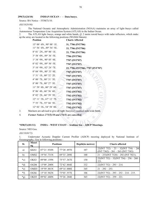
70299(T)/(24/10) INDIAN OCEAN – – Data buoys.Source: BA Notice – 5530(T)/10.(HJ/1028/80)1. The National Oceanic and Atmospheric Administration (NOAA) maintains an array of light–buoys calledAutonomous Temperature Line Acquisition System (ATLAS) in the <strong>Indian</strong> Ocean.2. The ATLAS light–buoys, orange and white bands, Q, 2 metre toroid buoys with radar reflectors, which makeup the array are located in the following positions (WGS84 Datum):PositionCharts Affected15° 00´·4N., 90° 00´·1E. 31, 7706 (INT706)11° 56´·4N., 89° 54´·5E. 33, 7706 (INT706)8° 01´·2N., 89° 00´·1E. 33, 7706 (INT706)3° 58´·0N., 89° 36´·5E. 7706 (INT706)1° 34´·9N., 90° 05´·8E. 7707 (INT707)0° 02´·9N., 89° 50´·5E. 7707 (INT707)3° 10´·9N., 82° 24´·7E. 23, 7706 (INT706), 7707 (INT707)0° 04´·9N., 80° 33´·8E. 7707 (INT707)1° 31´·1S., 80° 32´·2E. 7707 (INT707)4° 00´·7S., 80° 31´·5E. 7707 (INT707)8° 00´·7S., 80° 27´·5E. 7707 (INT707)11° 59´·8S., 80° 29´·6E. 7707 (INT707)8° 06´·4S., 66° 56´·6E. 7702 (INT702)8° 02´·2S., 66° 59´·5E. 7702 (INT702)12° 11´·3S., 67° 12´·7E. 7702 (INT702)7° 55´·7S., 55° 04´·5E. 7702 (INT702)12° 02´·3S., 54° 58´·0E. 7702 (INT702)3. Mariners are advised to give all light–buoys a 5 nautical mile wide berth.4. Former Notices 275(T)/10 and 276(T) are cancelled.*038(T)/(01/11) INDIA – WEST COAST – Arabian Sea – ADCP Moorings.Source: NIO Goa.(HJ/1030/72)1. Underwater Acoustic Doppler Current Profiler (ADCP) mooring deployed by National Institute ofOceanography, Goa in following positions:–Sl.MooringPositions Depth(in metres) Charts affecteda) KKS1 07°21´.934N 77°28´.497E 10722(INT 752) – 23 – 32(INT 754) – 260(INT 7362) – 261 – 263 (INT 7383)b) OMS2 19°54´.731N 69°33´.289E 100 21 – 253(INT 7328) – 292 (INT 7021).*c) OKS3 09°00´.159N 75°57´.367E 15022(INT 752) – 32(INT 754) – 256 – 260 –221.*d) OGD6 15°09´.200N 72°42´.884E 332 22(INT 752) – 293 – 214.*e) OMD3 19°59´.881N 69°14´.000E 345 21 – 292 – 253.*f) OGS6 15°10´.942N 73°03´.557E 106 22(INT 752) – 293 – 252 – 214 – 215.*g) OKD3 09°02´.680N 75°26´.284E 365 22(INT 752) – 259 – 221.


