annual edition - 2011 - Indian Naval Hydrographic Department
annual edition - 2011 - Indian Naval Hydrographic Department
annual edition - 2011 - Indian Naval Hydrographic Department
You also want an ePaper? Increase the reach of your titles
YUMPU automatically turns print PDFs into web optimized ePapers that Google loves.
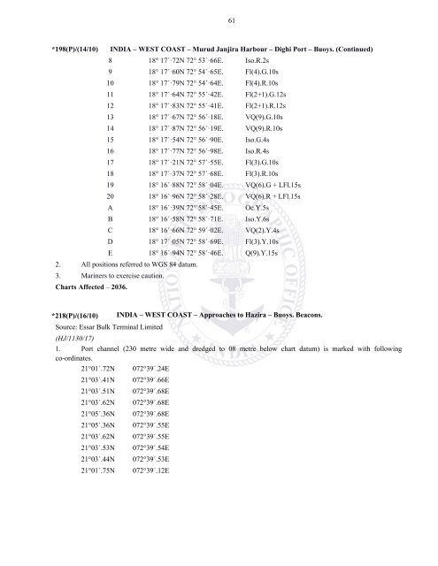
61*198(P)/(14/10) INDIA – WEST COAST – Murud Janjira Harbour – Dighi Port – Buoys. (Continued)8 18° 17´·72N 72° 53´·66E. Iso.R.2s9 18° 17´·60N 72° 54´·65E. Fl(4).G.10s10 18° 17´·79N 72° 54´·64E. Fl(4).R.10s11 18° 17´·64N 72° 55´·42E. Fl(2+1).G.12s12 18° 17´·83N 72° 55´·41E. Fl(2+1).R.12s13 18° 17´·67N 72° 56´·18E. VQ(9).G.10s14 18° 17´·87N 72° 56´·19E. VQ(9).R.10s15 18° 17´·54N 72° 56´·90E. Iso.G.4s16 18° 17´·77N 72° 56´·98E. Iso.R.4s17 18° 17´·21N 72° 57´·55E. Fl(3).G.10s18 18° 17´·37N 72° 57´·68E. Fl(3).R.10s19 18° 16´·88N 72° 58´·04E. VQ(6).G + LFl.15s20 18° 16´·96N 72° 58´·28E. VQ(6).R + LFl.15sA 18° 16´·39N 72° 58´·45E. Oc.Y.5sB 18° 16´·58N 72° 58´·71E. Iso.Y.6sC 18° 16´·66N 72° 59´·02E. VQ(2).Y.4sD 18° 17´·05N 72° 58´·69E. Fl(3).Y.10sE 18° 16´·94N 72° 58´·46E. Q(9).Y.15s2. All positions referred to WGS 84 datum.3. Mariners to exercise caution.Charts Affected – 2036.*218(P)/(16/10) INDIA – WEST COAST – Approaches to Hazira – Buoys. Beacons.Source: Essar Bulk Terminal Limited(HJ/1130/17)1. Port channel (230 metre wide and dredged to 08 metre below chart datum) is marked with followingco-ordinates.21°01´.72N 072°39´.24E21°03´.41N 072°39´.66E21°03´.51N 072°39´.68E21°03´.62N 072°39´.68E21°05´.36N 072°39´.68E21°05´.36N 072°39´.55E21°03´.62N 072°39´.55E21°03´.53N 072°39´.54E21°03´.44N 072°39´.53E21°01´.75N 072°39´.12E


