annual edition - 2011 - Indian Naval Hydrographic Department
annual edition - 2011 - Indian Naval Hydrographic Department
annual edition - 2011 - Indian Naval Hydrographic Department
Create successful ePaper yourself
Turn your PDF publications into a flip-book with our unique Google optimized e-Paper software.
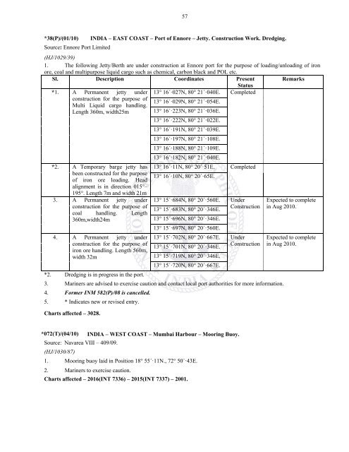
57*38(P)/(01/10)Source: Ennore Port LimitedINDIA – EAST COAST – Port of Ennore – Jetty. Construction Work. Dredging.(HJ/1029/39)1. The following Jetty/Berth are under construction at Ennore port for the purpose of loading/unloading of ironore, coal and multipurpose liquid cargo such as chemical, carbon black and POL etc.Sl. Description Coordinates Present Remarks*1. A Permanent jetty underconstruction for the purpose ofMulti Liquid cargo handling.Length 360m, width25m*2. A Temporary barge jetty hasbeen constructed for the purposeof iron ore loading. Headalignment is in direction 015°–195°. Length 7m and width 21m3. A Permanent jetty underconstruction for the purpose ofcoal handling. Length360m,width24mStatus13° 16´·027N, 80° 21´·040E. Completed13° 16´·029N, 80° 21´·054E.13° 16´·223N, 80° 21´·036E.13° 16´·222N, 80° 21´·022E.13° 16´·191N, 80° 21´·039E.13° 16´·197N, 80° 21´·108E.13° 16´·188N, 80° 21´·109E.13° 16´·182N, 80° 21´·040E.13° 16´·11N, 80° 20´·51E. Completed13° 16´·10N, 80° 20´·65E.13° 15´·684N, 80° 20´·560E.13° 15´·683N, 80° 20´·346E.UnderConstruction13° 15´·696N, 80° 20´·346E.13° 15´·697N, 80° 20´·560E.4. A Permanent jetty under 13° 15´·702N, 80° 20´·667E. Underconstruction for the purpose of13° 15´·701N, 80° 20´·346E.Constructioniron ore handling. Length 560m,width 32m13° 15´·719N, 80° 20´·346E.13° 15´·720N, 80° 20´·667E.*2. Dredging is in progress in the port.3. Mariners are advised to exercise caution and contact local port authorities for more information.4. Former INM 582(P)/08 is cancelled.5. * Indicates new or revised entry.Charts affected – 3028.Expected to completein Aug 2010.Expected to completein Aug 2010.*072(T)/(04/10) INDIA – WEST COAST – Mumbai Harbour – Mooring Buoy.Source: Navarea VIII – 409/09.(HJ/1030/87)1. Mooring buoy laid in Position 18° 55´·11N., 72° 50´·43E.2. Mariners to exercise caution.Charts affected – 2016(INT 7336) – 2015(INT 7337) – 2001.


