State Geological Map at Scale 1
State Geological Map at Scale 1
State Geological Map at Scale 1

Create successful ePaper yourself
Turn your PDF publications into a flip-book with our unique Google optimized e-Paper software.
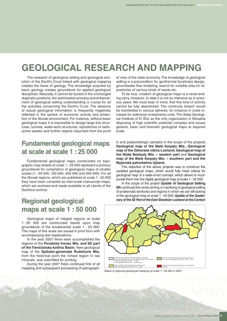
ORGANIZATION UNIT OF THE VICE-DIRECTOR FOR GEOLOGY * GEOLOGICAL DIVISIONGEOLOGICAL RESEARCH AND MAPPINGThe research of geological setting and geological evolutionof the Earth’s Crust linked with geological mappingcre<strong>at</strong>es the basis of geology. The knowledge acquired bybasic geology cre<strong>at</strong>es groundwork for applied geologicaldisciplines. N<strong>at</strong>urally, it cannot be buried in the unchangeddogm<strong>at</strong>ic positions; the optimiz<strong>at</strong>ion process and enhancementof geological setting understanding is crucial for allthe activities concerning the Earth’s Crust. The absenceof actual geological inform<strong>at</strong>ion is frequently neg<strong>at</strong>ivelyreflected in the sphere of economic activity and protectionof the Slovak environment. For instance, without basicgeological maps it is impossible to design large line structures,tunnels, w<strong>at</strong>er-work structures, repositories of radioactivewastes and further objects important from the pointof view of the st<strong>at</strong>e economy. The knowledge of geologicalsetting is a precondition for geothermal boreholes design,groundw<strong>at</strong>er flow modeling, search for suitable sites for repositoriesof various kinds of waste etc.To be true, cre<strong>at</strong>ion of geological maps is a never-endingstory. However, to d<strong>at</strong>e it is not so intensive as in previousyears. We must bear in mind, th<strong>at</strong> this kind of activitycannot be fully abandoned. The continuity breach wouldbe manifested in various spheres, for instance in costs increasefor extensive investments units. The <strong>St<strong>at</strong>e</strong> <strong>Geological</strong>Institute of D. Štúr as the only organiz<strong>at</strong>ion in Slovakiadisposing of high scientifi c potential compiles and issuesgeneral, basic and them<strong>at</strong>ic geological maps <strong>at</strong> requiredscale.Fundamental geological maps<strong>at</strong> scale <strong>at</strong> scale 1 : 25 000Fundamental geological maps constructed on topographicmap sheets <strong>at</strong> scale 1 : 25 000 represent a primarygroundwork for compil<strong>at</strong>ion of geological maps of smallerscales (1 : 50 000, 100 000, 200 000 and 500 000). For allthe Slovak regions, which are published <strong>at</strong> scale 1 : 50 000they have been compiled as inter-scale manuscript maps,which are archived and made available to all clients of theGeofond archive.Regional geologicalmaps <strong>at</strong> scale 1 : 50 000<strong>Geological</strong> maps of integral regions <strong>at</strong> scale1 : 50 000 are constructed based upon mapgroundwork of the fundamental scale 1 : 25 000.The maps of this scale are issued in print form withaccompanying text explan<strong>at</strong>ions.In the year 2007 there were accomplished theregions of the Považský Inovec Mts. and SE partof the Trenčianska kotlina Basin. New geologicalmap of the Spišsko-gemerské Rudohorie Mts,from the historical point the richest region in rawminerals, was submitted for printing.During the year 2007 there continued fi rst of allmapping and subsequent processing of petrographicand palaeontologic samples in the scope of the projects<strong>Geological</strong> map of the Malé Karp<strong>at</strong>y Mts., <strong>Geological</strong>map of the Záhorská nížina Lowland, <strong>Geological</strong> map ofthe Nízke Beskydy Mts. – western part and <strong>Geological</strong>map of the Biele Karp<strong>at</strong>y Mts. – southern part and theMyjavská pahork<strong>at</strong>ina Upland.The objective of the above projects was to construct theupd<strong>at</strong>ed geological maps, which would fully meet criteria forgeological map of a st<strong>at</strong>e-of-art concept, which allows to incorpor<strong>at</strong>ethem into the digital geological map <strong>at</strong> scale 1 : 50 000.In the scope of the project Upd<strong>at</strong>e of <strong>Geological</strong> SettingSR continued the works aiming on clarifying of geological settingof problem<strong>at</strong>ic territories and regions in which we are still lackingof the geological map <strong>at</strong> scale 1 : 50 000: Upd<strong>at</strong>e of the Qu<strong>at</strong>ernaryof the SE Part of the East-Slovakian Lowland <strong>at</strong> the Contactregions with non-approved them<strong>at</strong>ic geological groundworkregion covered by regional geological maps issued onor without geological maps (only with upd<strong>at</strong>ed regions for the needs ofnon-deformed topographic groundwork (1992 – 2007)Digital <strong>Geological</strong> <strong>Map</strong> <strong>at</strong> scale 1 : 50 000),or with geological map <strong>at</strong> scale 1 : 25 000 solelyregion covered by regional geological maps issued onregion covered by regional geological maps completeddeformed topographic groundwork (1973 – 1992)by 2007St<strong>at</strong>us of regional geological mapping <strong>at</strong> scale 1 : 50 000 in 2007.<strong>St<strong>at</strong>e</strong> <strong>Geological</strong> Institute of Dionýz Štúr Annual Report 2007 9