State Geological Map at Scale 1
State Geological Map at Scale 1
State Geological Map at Scale 1

You also want an ePaper? Increase the reach of your titles
YUMPU automatically turns print PDFs into web optimized ePapers that Google loves.
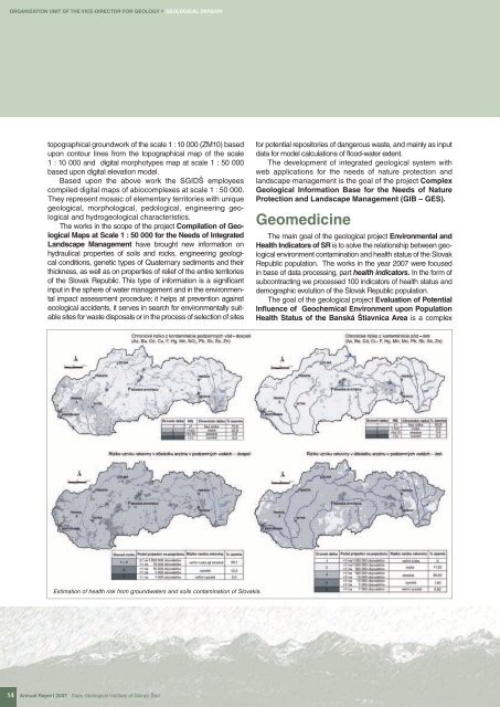
ORGANIZATION UNIT OF THE VICE-DIRECTOR FOR GEOLOGY * GEOLOGICAL DIVISIONtopographical groundwork of the scale 1 : 10 000 (ZM10) basedupon contour lines from the topographical map of the scale1 : 10 000 and digital morphotypes map <strong>at</strong> scale 1 : 50 000based upon digital elev<strong>at</strong>ion model.Based upon the above work the SGIDŠ employeescompiled digital maps of abiocomplexes <strong>at</strong> scale 1 : 50 000.They represent mosaic of elementary territories with uniquegeological, morphological, pedological, engineering geologicaland hydrogeological characteristics.The works in the scope of the project Compil<strong>at</strong>ion of <strong>Geological</strong><strong>Map</strong>s <strong>at</strong> <strong>Scale</strong> 1 : 50 000 for the Needs of Integr<strong>at</strong>edLandscape Management have brought new inform<strong>at</strong>ion onhydraulical properties of soils and rocks, engineering geologicalconditions, genetic types of Qu<strong>at</strong>ernary sediments and theirthickness, as well as on properties of relief of the entire territoriesof the Slovak Republic. This type of inform<strong>at</strong>ion is a significantinput in the sphere of w<strong>at</strong>er management and in the environmentalimpact assessment procedure; it helps <strong>at</strong> prevention againstecological accidents, it serves in search for environmentally suitablesites for waste disposals or in the process of selection of sitesfor potential repositories of dangerous waste, and mainly as inputd<strong>at</strong>a for model calcul<strong>at</strong>ions of flood-w<strong>at</strong>er extent.The development of integr<strong>at</strong>ed geological system withweb applic<strong>at</strong>ions for the needs of n<strong>at</strong>ure protection andlandscape management is the goal of the project Complex<strong>Geological</strong> Inform<strong>at</strong>ion Base for the Needs of N<strong>at</strong>ureProtection and Landscape Management (GIB – GES).GeomedicineThe main goal of the geological project Environmental andHealth Indic<strong>at</strong>ors of SR is to solve the rel<strong>at</strong>ionship between geologicalenvironment contamin<strong>at</strong>ion and health st<strong>at</strong>us of the SlovakRepublic popul<strong>at</strong>ion. The works in the year 2007 were focusedin base of d<strong>at</strong>a processing, part health indic<strong>at</strong>ors. In the form ofsubcontracting we processed 100 indic<strong>at</strong>ors of health st<strong>at</strong>us anddemographic evolution of the Slovak Republic popul<strong>at</strong>ion.The goal of the geological project Evalu<strong>at</strong>ion of PotentialInfluence of Geochemical Environment upon Popul<strong>at</strong>ionHealth St<strong>at</strong>us of the Banská Štiavnica Area is a complexEstim<strong>at</strong>ion of health risk from groundw<strong>at</strong>ers and soils contamin<strong>at</strong>ion of Slovakia.14 Annual Report 2007 <strong>St<strong>at</strong>e</strong> <strong>Geological</strong> Institute of Dionýz Štúr